

6 PM: New Lava Flow Expected to Enter Ocean
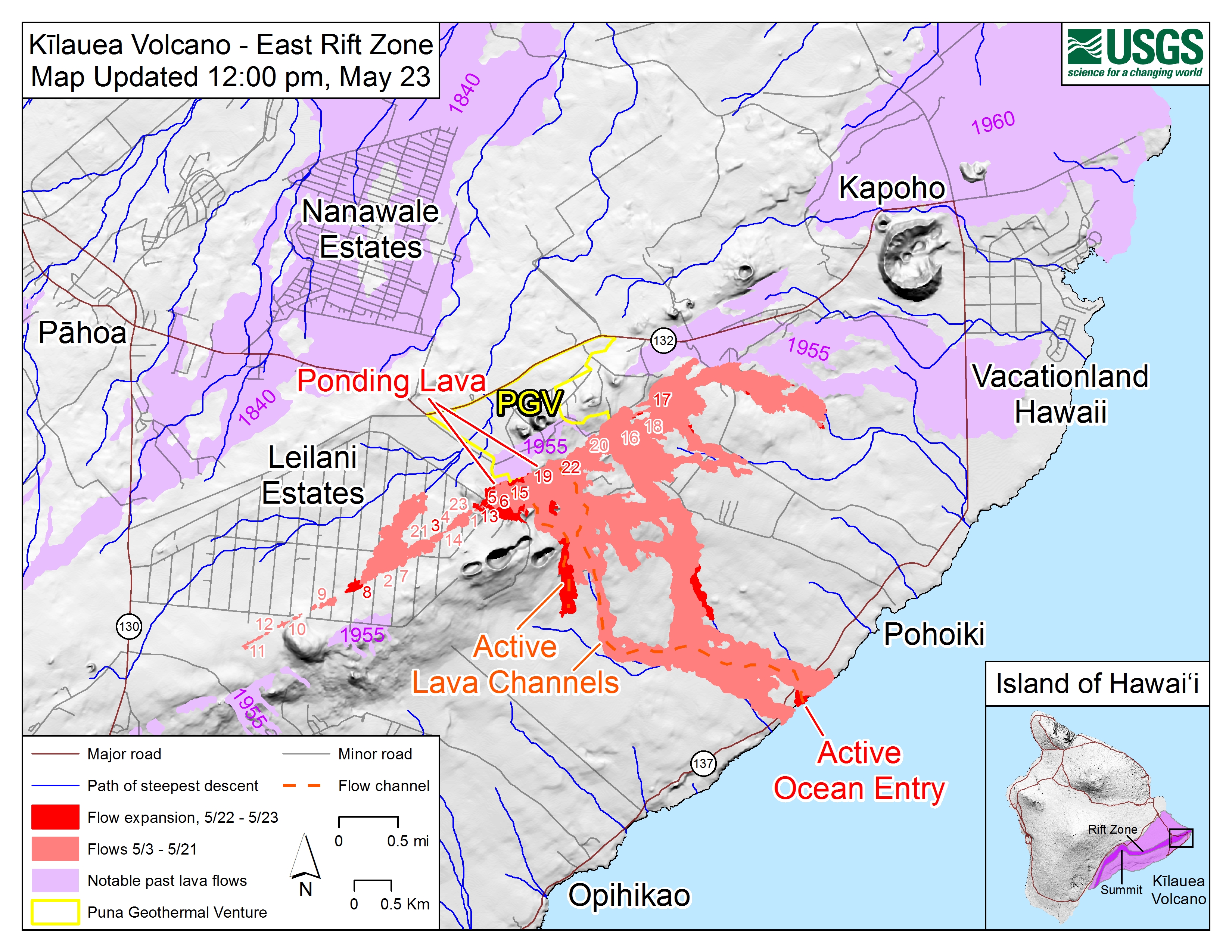
Map as of 12:00 p.m., May 23, 2018. On the main map, light purple areas indicate lava flows erupted in 1840, 1955, 1960, and 2014-2015. On the inset map (lower right), the dark purple area indicates locations of Kīlauea Volcano’s East Rift Zone, Southwest Rift Zone, and summit, and the light purple area indicates the extent of Kīlauea.
Wednesday, May 23, 2018, 6 p.m.
Hawaiian Volcano Observatory reports a new lava flow is expected to enter the ocean east of MacKenzie State Park tonight.
The situation at Puna Geothermal Venture remains stable. Lava has not encroached further onto PGV property.
County, state and federal crews are on the scene at PG and monitoring for sulfur dioxide and hydrogen sulfide. There is no hydrogen sulfide detected at this time.
Frequent ash emissions continue at the Kīlauea summit. Take action to avoid exposure
to ash.
HAWAIIAN VOLCANO OBSERVATORY DAILY UPDATE, 4:47 p.m.
LOWER EAST RIFT ZONE
Moderate-level eruption of lava continues from multiple points along the central and northeast end of the active fissure system.
Residents in lower Puna should remain informed and heed Hawai‘i County Civil Defense closures, warnings and messages. Conditions around the erupting fissures can change very quickly.
Fissure 6 through 22 continue erupting lava fountains. The fountains from Fissure 22 feed a single lava channel that reaches the coast just north of MacKenzie State Park. The actual point of entry has continued shifting to the west.
Fountains erupted from Fissures 5, 6, 13 and 19 continued to feed a lava flow advancing to the south along the west side of the Fissure 22 flows and may reach the ocean this afternoon or evening.
Fissure 17 continue weak spattering. Fissure 8 reactivated briefly this morning to erupt two small pahoehoe flows over the initial ‘a‘a flow.
HVO field crews are on site tracking the lava flows and spattering from multiple fissures as conditions allow and reporting information to Hawai‘i County Civil Defense.
Volcanic gas emissions have tripled as a result of the voluminous eruptions from the erupting fissures so SO2 concentrations are likely elevated to higher levels throughout the area downwind of the vents.
Moderate trade winds today means that areas downwind of Kīlauea gas emission sources may experience varying levels of vog. For forecast information, go online.
For other information about vog, go online.
This eruption is still evolving and additional outbreaks of lava are possible. Ground deformation has slowed and seismicity levels have decreased in the area.
Future outbreaks could occur both uprift (southwest) and downrift (northeast) of the existing fissures, or, existing fissures can be reactivated. Communities downslope of the fissure system could be at risk from lava inundation. Activity can change rapidly.
The ocean entry is a hazardous area. Hazards include walking on uneven, glassy lava flow surfaces and around unstable, vertical sea cliffs. Venturing too close to an ocean entry on land or the ocean exposes you to flying debris from sudden explosive interaction between lava and water. Also, the lava delta is unstable because it is built on unconsolidated lava fragments and sand. This loose material can easily be eroded away by surf, causing the new land to become unsupported and slide into the sea. In several instances, such collapses have also incorporated parts of the older sea cliff. Additionally, the interaction of lava with the ocean creates “laze,” a corrosive seawater plume laden with hydrochloric acid and fine volcanic particles that can irritate the skin, eyes, and lungs.
KILAUEA SUMMIT
Multiple small eruptions of ash occurred over the past day, all ejecting ash to under 10,000 feet above sea level. One of the largest occurred about 10:30 this morning. Additional explosions are possible at any time.
Seismic levels, which abruptly decreased after the recent explosive eruptions, are again slowly increasing.
At this time, based on HVO web cameras, a robust plume of gas and steam is billowing out of the Overlook vent and drifting generally southwest.
At any time, activity may again become more explosive, increasing the intensity of ash production and producing ballistic projectiles very near the vent. Communities downwind should be prepared for ashfall as long as this activity continues.
Resources on volcanic ash hazards and preparedness information: https://volcanoes.usgs.gov/volcanic_ash/ OR http://www.ivhhn.org/ash-protection.
Resources on vog: https://vog.ivhhn.org/
National Weather Service ashfall information and advisories: https://forecast.weather.gov/
Seismicity and deformation continue at the Kīlauea summit. Deflation is ongoing. Additional earthquakes in the Kilauea summit area are expected as long as the summit continues to deflate.
Noon
The middle portion of the fissure system in the Lower East Rift Zone continues to be the most active.
Lava eruption and ground cracking continues in the area of Leilani Estates and Lanipuna Gardens.
Frequent ash emissions continue at the Kīlauea summit, resulting in plumes up to 8,000 feet high. Take action to avoid exposure to ash.
To help our residents, free masks for ash protection are being distributed Wednesday through Friday, May 23 through 25, from 3:30 to 7:30 p.m. and Saturday, May 26, from 9 a.m. to 1 p.m.
Masks will be distributed at Ocean View Community Center, Naalehu Community Center, Pahala Community Center, Cooper Center, and Shipman Gym in Keaau.
Each person may receive up to three masks.
Masks do not protect against gasses and vapors. They will only provide filtering for ash.

Live panorama of Kīlauea Caldera from HVO Observation Tower, 2018-05-23 9:50 a.m.
This image is from a research camera mounted in the observation tower at the Hawaiian Volcano Observatory. The camera is looking SSE towards the active vent in Halemaʻumaʻu. 1.2 miles from the webcam.
9:30 a.m.
Hawaiian Volcano Observatory reports eruption activity continues in the Lower East Rift Zone. Several fissures are still very active, fountaining lava and spanning about a mile along the rift from Leilani Estates to Lanipuna.
Frequent ash emissions continue at the Kīlauea summit, resulting in plumes less than 8,000 feet high. Take action to avoid exposure to ash.
Due to continued volcanic activity, the following is provided for your information:
County, state and federal partners are working together to monitor the situation at Puna Geothermal Venture and will continue to work on the wells.
Due to increased gas emissions in the Lower East Rift Zone, the following policies are in effect:
Hawai‘i County, state Department of Health and U.S. Environmental Protection Agency are working together to increase air quality monitoring activity.
New equipment will be added throughout the East Rift Zone to monitor for hydrogen sulfide and sulfur dioxide. No hydrogen sulfide has been detected at this time.
Information gathered from the monitors will be used by Civil Defense and first responders to provide updates to the public.
Residents can learn more about current sulfur dioxide emission levels and forecasts by visiting the University of Hawai‘i’s Vog Measurement and Prediction Project website.
6 a.m.
Hawaiian Volcano Observatory reports eruption activity continues in the Lower East Rift Zone.
County, state and federal partners are working together to monitor the situation at Puna Geothermal Venture. Government departments alongside PGV will continue to work on the wells.
Hawai‘i County Fire Department, state Department of Health and U.S. Environmental Protection Agency continue to monitor the air quality in the Lower East Rift Zone.
County of Hawai‘i, American Red Cross, and other agencies continue to ensure pet-friendly shelters are open and support services are available if residents need to leave their homes.

This thermal map shows the fissure system and lava flows as of 06:45 am on Tuesday, May 22. (Click to see larger map.)
MAP: This thermal map shows the fissure system and lava flows as of 06:45 am on Tuesday, May 22. The primary lava flow originates from Fissure 22, but a new flow has been active over the past day from the Fissure 6 area. The black and white area is the extent of the thermal map. Temperature in the thermal image is displayed as gray-scale values, with the brightest pixels indicating the hottest areas. The thermal map was constructed by stitching many overlapping oblique thermal images collected by a handheld thermal camera during a helicopter overflight of the flow field. The base is a copyrighted color satellite image (used with permission) provided by Digital Globe.
HAWAIIAN VOLCANO OBSERVATORY STATUS REPORT
U.S. Geological Survey
Wednesday, May 23, 6:05 a.m.

View during an early morning overflight of Kīlauea Volcano’s lower East Rift Zone. Two fissures (not pictured) are sending lava down two channels that merge near the coast. May 22, 2018. PC: USGS
Kīlauea Volcano Lower East Rift Zone
Eruption of lava and ground cracking continues in the area of Leilani Estates and Lanipuna Gardens subdivision.
The middle portion of the fissure system continues to produce the most robust eruptive activity in the Lower East Rift Zone. The most active fissures have been 22,19, 6, 5 and 23.

Solidified lava from Fissure 17 (located to the east of the currently active fissure complex) has a consistency similar to toothpaste. May 22, 2018. PC: USGS
A faint glow was seen from Fissure 9, but no flows erupted. Methane was observed burning in road cracks overnight.
The ocean entry remains active and is producing occasional small explosions. Observers noted the height of the perched lava pond/channel had reached 36 feet above the ground level.
Lava is probably still entering the ocean. Although HVO can’t get visual confirmation until after dawn, instrumental signals are consistent with continuing ocean entry activity.
Volcanic gas emissions remain very high from these fissure eruptions.
Additional ground cracking and outbreaks of lava are possible in the area. Residents downslope of the region of fissures should heed all Hawaii County Civil Defense messages and warnings.
Magma continues to be supplied to the lower East Rift Zone. Elevated earthquake activity continues, but earthquake locations have not moved farther downrift in the past couple of days, and there were only a few earthquakes located yesterday in the rift zone.

Aerial view of an active lava breakout. May 22, 2018. PC: USGS
USGS/HVO continues to monitor the lower East Rift Zone activity 24/7 in coordination with Hawai‘i County Civil Defense, with geologists onsite to track ongoing and new fissure activity and the advance of lava flows.

Kīlauea Caldera from HVO Observation Tower, 2018-05-23 9 a.m. PC: USGS/HVO
Kīlauea Volcano Summit
Small ash emissions from Overlook Crater occurred frequently throughout the night. Moderate trade winds were blowing to the southwest and ashfall may be noticed in downwind locations.

The fissure complex remains active in Kīlauea Volcano’s lower East Rift Zone. At times, fountaining at Fissure 22 reached a height of about about 160 feet. May 22, 2018. PC: USGS
Earthquakes in the summit area continue at a moderate rate, as does deflation of the summit region.
Additional explosive events that could produce minor amounts of ashfall downwind are possible at any time. Volcanic gas emissions at the summit remain high.
For forecasts of where ash would fall if such an explosion occur, go online.

The fissure complex, pictured in the upper right, continues to feed a meandering lava flow (in the center). Lava in the easternmost lobe is entering the ocean (white plume). May 22, 2018. PC: USGS
Information on ash hazards and how to prepare for ashfall maybe found here.
The fissure complex remains active in Kīlauea Volcano’s lower East Rift Zone.
At times, fountaining at Fissure 22 reached a height of about about 160 feet.
Sponsored Content


