

6 AM UPDATE: Madeline Passes South of Big Island
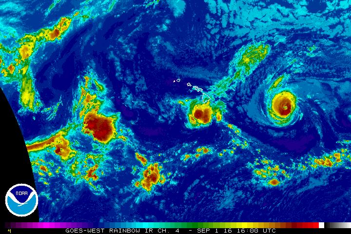
Hurricanes Madeline & Lester, Thursday Sept. 1, 2016, 6 a.m. NOAA/NWS
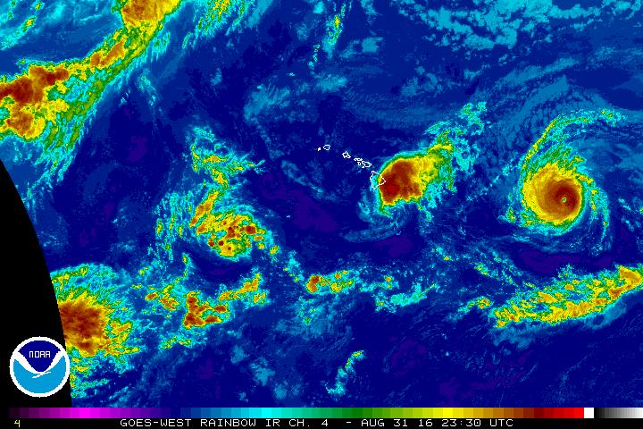
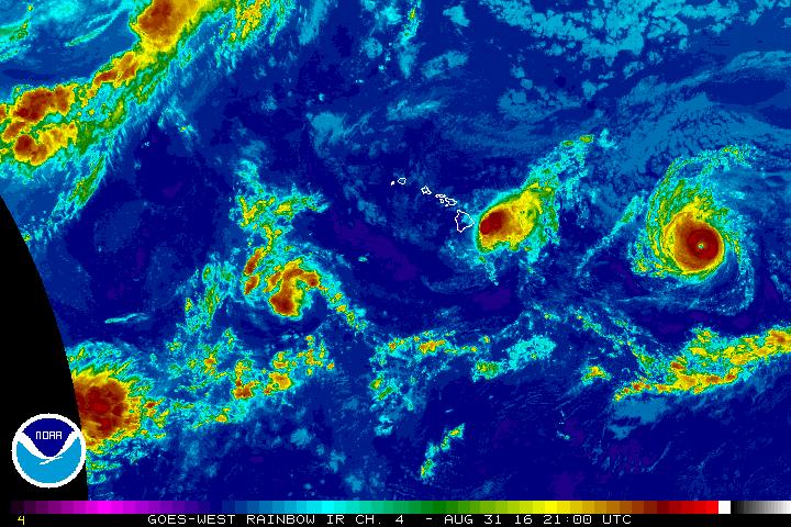
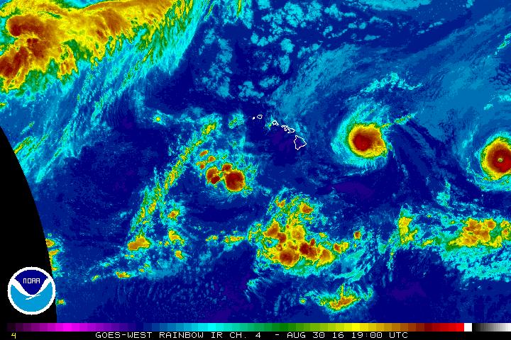
Hurricane Madeline, Wednesday, Aug. 31, 7 p.m.
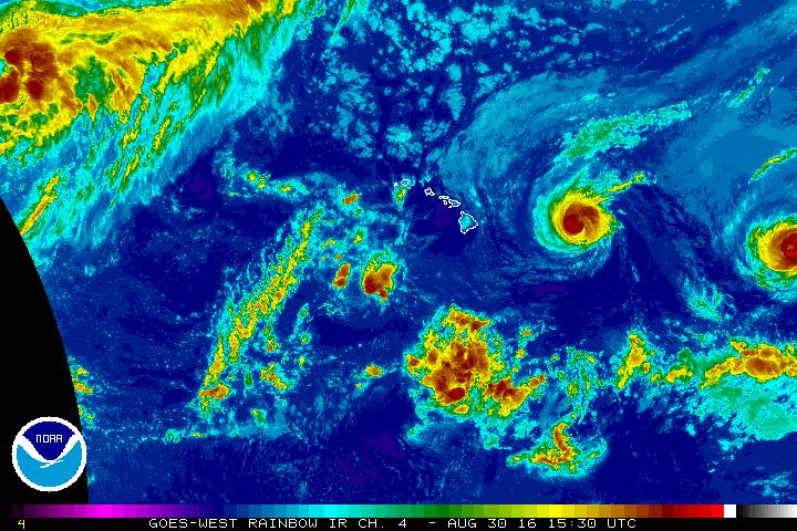
Hurricane Madeline, Wednesday, Aug. 31, 2:30 p.m.
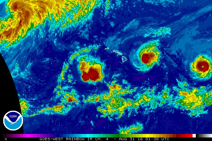
Hurricane Madeline, Wednesday, Aug. 31, 1:30 p.m.
Click here for updates on closures and cancellations for Hawai‘i County
Click here for power, road and flooding status reports
Click here for emergency shelter information
Click here for hurricane safety tips
Click here for airline information
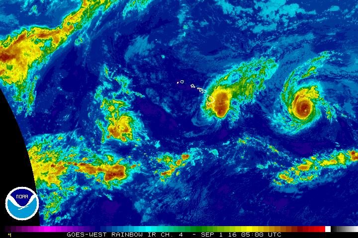
UDATE: Thursday, Sept. 1, 5:30 a.m.
This is a Tropical Storm Madeline and Hurricane Lester update for Thursday, Sept. 1 at 5:30 a.m.
The National Weather Service has cancelled the Tropical Storm Warning for Madeline as it has passed to the south of Hawai‘i Island.
County and state facilities, offices and services will resume today including Hele-On Bus service and solid waste transfer stations. Parks will reopen pending damage assessments. All roads have reopened.
Damage Assessment teams will be out in targeted areas today. If your home or business has been damaged, call Civil Defense at 935-0031.
In anticipation of Hurricane Lester, the National Weather Service has issued a Hurricane Watch for Hawai‘i County.
As of 5 a.m., Lester is about 750 miles east of Hilo moving west at 14 miles per hour with maximum sustained winds of 105 miles per hour. High surf is expected to begin building today on east facing shores. Heavy rains and winds from Lester are possible on Saturday.
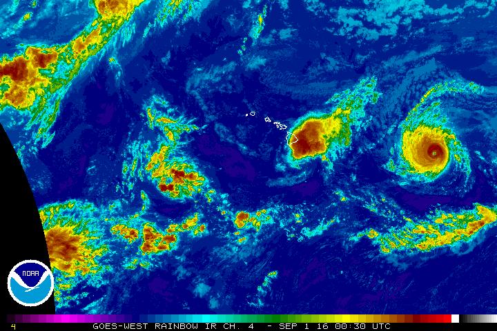
UPDATE: Wednesday, Aug. 31, 7 p.m.
The National Weather Service reports on Wednesday, Aug. 31, at 7 p.m. that Tropical Storm Madeline is continuing to weaken, and Hawai‘i County remains under a Tropical Storm Warning.
Madeline is still a powerful storm, and the public is reminded to stay off roads as the center of Madeline continues to pass south of the Big Island.
As of 5 p.m., the National Weather Service reported that Madeline was located about 115 miles south of Hilo, moving west at 12 miles per hour with maximum sustained winds of 65 miles per hour.
High wind, high surf, and heavy rain conditions are continuing to affect Hawai‘i Island.
If possible and safe, shelter in place or with family and friends. Otherwise, a list of open shelters is available here.
UPDATE: Wednesday, Aug. 31, 6:18 p.m.
The National Weather Service has extended the flood advisory for North Hilo, South Hilo and Puna Districts to 9:15 p.m. tonight. (See “UPDATE: Wednesday, Aug. 31, 2 p.m.” below for more information.)
At 6:18 p.m., radar indicated that heavy rainfill has spread into the Kau District with rates of up to one inch per hour.
UPDATE: Wednesday, Aug. 31, 4:54 p.m.
The National Weather Service has extended the flood advisory for North Hilo, South Hilo and Puna Districts to 8 p.m. tonight. (See “UPDATE: Wednesday, Aug. 31, 2 p.m.” below for more information.)
UPDATE: Wednesday, Aug. 31, 2 p.m.
At 2 p.m. Wednesday, Aug. 31, the National Weather Service in Honolulu issued a flood advisory for Hawaii County until 5 p.m., Wednesday, Aug. 31.
At 1:53 p.m., radar and rain gages indicated that heavy rain associated with Hurricane Madeline was occurring over North Hilo, Soth Hilo and Puna Districts with rates of 1 to 2 inches per hour.
Radar showed more areas of heavy rain will continue to move over the eastern slopes of the Big Island during the next several hours.
Locations in the advisory include but are not limited to Hilo, Hawaiian Paradise Park, Honolu, Keaau, Pahoa, Pepe‘ekeo, Pahala, Glenwood, Hawaiian Acres, Mountain View, Volcano and Hawai‘i Volcanoes National Park.
Stay away from streams, drainage ditches and low-lying areas prone to flooding.
Rainfall and runoff will also cause hazardous driving conditions due to ponding, reduced visibility and poor braking action.
Do not cross fast flowing or rising water in your vehicle or on foot.
This advisory may need to be extended beyond 5 p.m. if heavy rain persists.
A flash flood watch is also in effect for Hawai‘i County through Thursday, Sept. 1.
UPDATE: Wednesday, Aug. 31, 11 a.m.
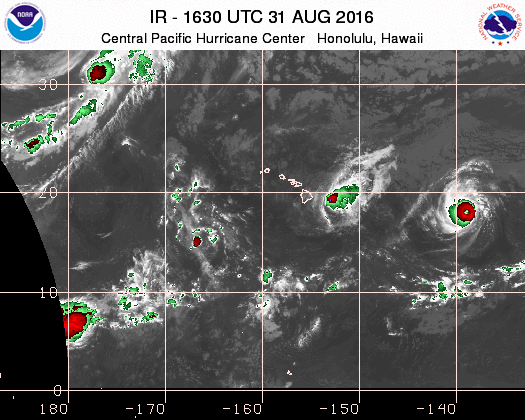
Hurricane Madeline, Wednesday, Aug. 31, 11-30 a.m. NOAA/NWS
The National Weather Service in Honolulu has cancelled the Hurricane Warning for Hurricane Madeline for Hawai‘i County at 11:06 a.m., Wednesday, Aug. 31
Although Hurricane Madeline is weakening as it draws closer to Hawai‘i, a tropical storm warning is in effect for Hawai‘i County. Madeline is still a powerful storm, and the public is reminded to be prepared.
The center of Madeline is forecast to pass south of Hawai‘i Island this evening, Wednesday, Aug. 31.
High wind, high surf, and heavy rain conditions are already affecting Hawai‘i Island.
A flash flood watch is in effect for the big island today, Wednesday, Aug. 31 through Thursday, Sept. 1.
At 11 a.m., the center of Hurricane Madeline was located about 95 miles southeast of Hilo, moving west at 13 mph. Maximum sustained winds are near 75 mph.
Big Islanders are still advised to stay inside, preferably in an interior room and way from windows. Do not venture outside when high winds are occurring or during temporary lulls as flying debris can cause serious injury.
Have a well-charged cell phone handy, but save it for emergencies only. This will help keep network communications open and conserve your battery power.
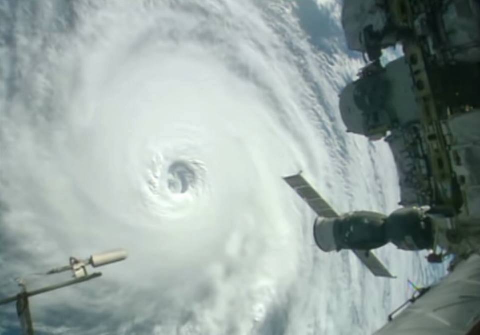
International Space Station photo of Hurricane Lester.
International Space Station VIDEO of Madeline, Lester and Gaston: Aug 30
Cameras outside the International Space Station captured spectacular views of three powerful tropical systems churning across the Pacific and Atlantic Oceans from 257 miles above the Earth on Aug. 30, 2016.
VIDEO UPDATE WITH MALIKA DUDLEY, Wednesday, Aug. 31, 6:30 a.m.
Hurricanes Madeline and Lester, Wednesday, Aug 31, 6:30 a.m.
UPDATE: Wednesday, Aug. 31, 7:30 a.m.
The National Weather Service in Honolulu has just issued a flood advisory for Hawai‘i County until 10:15 a.m., Wednesday, Aug. 31.
At 7:15 a.m. Radar and rain gages indicated heavy rain associated with the outer bands of hurricane madeline over the South Hilo and Puna Districts. Rain was falling at a rate of 1 to inches per hour. Additional rainfall is expected to move over
the eastern slopes of the big island through the day.
Locations in the advisory include but are not limited to Hilo, Hawaiian Paradise Park, Kea‘au, Pahoa, Pepeekeo, Glenwood, Hawaiian Acres, Mountain View, Papaikou, Volcano,, Hawaii Volcanoes National Parke and Orchidland Estates.
Stay away from streams, drainage ditches and low-lying areas prone to flooding.
Rainfall and runoff will also cause hazardous driving conditions due to ponding, reduced visibility and poor braking action.
Do not cross fast flowing or rising water in your vehicle or on foot.
This advisory may need to be extended beyond 10:15 a.m. if heavy rain persists.
A flash flood watch is also in effect for Hawai‘i County through Thursday, Sept. 1.
The National Hurricane Center in Miami, Florida is issuing advisories on Hurricane Lester, located about 1,050 miles east of Hilo. Lester is forecast to move into the Central Pacific Hurricane Center’s area of responsibility later today.
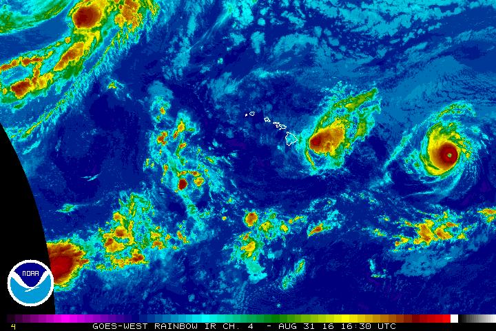 Hurricane Madeline. Wednesday, Aug. 31, 6 a.m.
UPDATE: Wednesday, Aug. 31, 5 a.m.
The Hurricane Warning issued by the National Weather Service remains in effect for Hawai‘i County..
As of 5 a.m. this morning, Wednesday, Aug. 31, the National Weather Service reported that Hurricane Madeline was located about 140 miles east-south-east of Hilo moving west at 14 miles per hour with maximum sustained winds of 80 miles per hour with higher gusts.
The center of Madeline is forecast to pass very close to the south of South Point on the Big Island today.
Surf heights are forecast to reach 15 to 25 feet.
Heavy rains are also forecast with greatest amounts over windward areas. This rainfall may lead to dangerous flash floods and mudslides.
Tropical storm-force winds and possibly hurricane-force winds are also expected over Hawaii County today.
The public is advised to be StormReady. Find tips and sign up for notifications at hawaiicounty.gov.
Hurricane Madeline, Aug. 30, 3:30 p.m. NOAA-NWS
UPDATE: Tuesday, Aug. 30, 8 p.m.
The Hurricane Warning issued by the National Weather Service remains in effect for Hawai‘i County. Hurricane conditions are expected within the next 36 hours.
At 8 p.m. tonight, the National Weather Service reported that Hurricane Madeline was located about 275 miles east of Hilo moving west at 10 miles per hour with maximum sustained winds of 95 miles per hour with higher gusts.
The center of Madeline is forecast to pass very close to the south of South Point on the Big Island sometime tomorrow.
High surf conditions are expected to begin building along east facing shores of the Big Island tonight. Heavy rains are forecast to arrive tomorrow with greatest amounts over windward areas. This rainfall may lead to dangerous flash floods and mudslides. Tropical storm-force winds and possibly hurricane-force winds are expected over Hawai‘i County sometime tomorrow.
The public is advised to prepare for this storm. Find tips and sign up for notifications at hawaiicounty.gov.
All Hawaii Island public and private schools islandwide, including charter schools, UH Hilo, and Hawaii Community Colleges, will be closed tomorrow.
UPDATE: Aug 30, 7:38 p.m.
The Central Pacific Hurricane Center in Honolulu is issuing advisories on Hurricane Madeline, located about 300 miles east of Hilo.
The National Hurricane Center in Miami, Florida, is issuing advisories on Hurricane Lester, located about 1,200 miles east of Hilo. Lester is forecast to move into the Central Pacific Hurricane Center’s area of responsibility Wednesday.
UPDATE: Tuesday, Aug. 30, 4 p.m.
The Hurricane Warning that is now in effect for Hawaii County means hurricane conditions are expected within the next 36 hours.
At 2 p.m. today, the National Weather Service reported that Hurricane Madeline was located about 350 miles east of Hilo moving west at 10 miles per hour with maximum sustained winds of 110 miles per hour with higher gusts.
The National Weather Service forecasts the center of Madeline to pass very close to the south of South Point on the Big Island sometime tomorrow.
High surf generated by Madeline is expected along east facing shores of the Big Island starting tonight.
Heavy rains associated with Madeline may reach Hawai‘i County on Wednesday with greatest amounts over windward areas.
This rainfall may lead to dangerous flash floods and mudslides.
Tropical-storm-force winds and possible hurricane-force winds are expected over Hawai‘i County sometime tomorrow.
In preparation for Hurricane Madeline, the public is advised to be StormReady. Find StormReady tips and sign up for notifications at hawaiicounty.gov.
UPDATE: Aug. 30, 11:30 a.m.
Hurricane Madeline, Aug. 30, 9 a.m. NOAA, NWS
This is a Hurricane Madeline update for Tuesday, Aug. 30 at noon.
A Hurricane Warning is now in effect for Hawaii County. A Hurricane Warning means that hurricane conditions are expected within the warning area within the next 36 hours. Preparations to protect life and property should be completed by nightfall today.
As of 11 a.m. today the National Weather Service reports Hurricane Madeline is located about 370 miles east of Hilo. Madeline is a category three hurricane with maximum sustained winds of 115 miles per hour with higher gusts. Some weakening is forecast during the next 48 hours.
Madeline is moving west at 10 miles per hour. This motion is expected to continue today, followed by a turn toward the west-southwest tonight through early Thursday. On this forecast track, the center of Madeline will pass very close to South Point of the Big Island.
The following hazards are anticipated:
Hurricane force winds are expected over Hawaii County sometime Wednesday into early Thursday.
Ocean swells generated by Madeline are expected to build from east to west across the Hawaiian Islands today and tonight, possibly becoming damaging along east facing shores of the Big Island.
Heavy rains associated with Madeline may reach Hawaii County on Wednesday with greatest amounts over windward areas. This rainfall may lead to dangerous flash floods and mudslides.
In preparation for Hurricane Madeline, the public is advised to be StormReady.
Build or restock your emergency preparedness kit. Include a flashlight with fresh batteries, cash, first aid supplies, and any medication or supplies specific to you or your family members.
Plan how to communicate with family members. Create an evacuation plan for your household. Bring in or secure outdoor furniture and other items that could blow away. Keep your vehicle fueled and cell phone charged.
To help preserve water availability through the storm, the Department of Water Supply asks customers to minimize non-essential use of water, such as irrigation.
Find more StormReady tips and sign up for notifications at hawaiicounty.gov.
VIDEO UPDATE: Tuesday, Aug. 30, 5:30 a.m.
The National Weather Service has issued a Tropical Storm Warning for the Island of Hawai‘i. A tropical storm warning means that tropical storm conditions are expected within 36 hours.
As of 5 a.m. today the National Weather Service reports Hurricane Madeline is located about 445 miles east of Hilo, moving west at 10 miles per hour. Maximum sustained winds of 120 miles per hour.
The following hazards are anticipated:
Tropical Storm force winds are possible over Hawai‘i County on Wednesday.
Ocean swells generated by Hurricane Madeline are expected to reach the Hawaiian Islands over the next couple of days, possibly becoming damaging along some coastlines Wednesday and Thursday.
Heavy rains associated with Madeline may reach Hawai‘i County on Wednesday, and may impact other Hawaiian Islands later Wednesday into Friday. This rainfall may lead to dangerous flash floods and mudslides.
In preparation for Hurricane Madeline, the public is advised to be storm ready.
Build or restock your emergency preparedness kit. Include a flashlight with fresh batteries, cash, first aid supplies, and any medication or supplies specific to you or your family members.
Plan how to communicate with family members. Create an evacuation plan for your household. Bring in or secure outdoor furniture and other items that could blow away. Keep your vehicle fueled and cell phone charged.
To help preserve water availability through the storm, the Department of Water Supply asks customers to minimize non-essential use of water, such as irrigation, at this time.
Find more StormReady tips and sign up for notifications at hawaiicounty.gov.
Madeline and Lester, Monday, Aug. 30, 6 a.m. NOAA, NWS
UPDATE: Monday, Aug. 29, 6 p.m.
A Hurricane Watch is in effect for Hawai‘i County.
A Hurricane Watch means that hurricane conditions are possible in Hawai‘i County within the next 48 hours.
As of 5 p.m. today, the National Weather Service reports Hurricane Madeline is located about 575 miles east of Hilo.
Madeline is a category three hurricane with maximum sustained winds of 125 MPH with higher gusts.
Madeline is moving to the west-northwest at 10 miles per hour.
The following hazards are anticipated:
Hurricane force winds are possible over Hawai‘i County on Wednesday.
Ocean swells generated by Madeline are expected to reach the Hawaiian Islands over the next couple of days, possibly becoming damaging along some coastlines Wednesday and Thursday.
Heavy rains associated with Madeline may reach Hawai‘i County on Wednesday, and may impact other Hawaiian Islands later Wednesday into Friday. This rainfall may lead to dangerous flash floods and mudslides.
In preparation for Hurricane Madeline, the public is advised to be storm ready.
Build or restock your emergency preparedness kit. Include a flashlight with fresh batteries, cash, first aid supplies, and any medication or supplies specific to you or your family members.
Plan how to communicate with family members. Create an evacuation plan for your household. Bring in or secure outdoor furniture and other items that could blow away. Keep your vehicle fueled and cell phone charged.
To help preserve water availability through the storm, the Department of Water Supply asks customers to minimize non-essential use of water, such as irrigation, at this time.
Find more StormReady tips and sign up for notifications at hawaiicounty.gov.
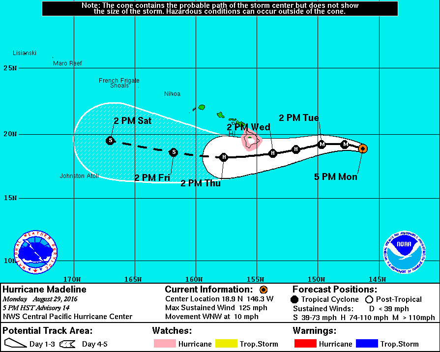
Hurricane Madeline track as of Monday, Aug. 29, 5 p.m. HST.
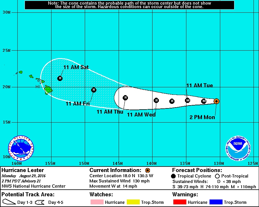
Lester track as of Monday, Aug. 29.
UPDATE FROM HAWAI‘I ISLAND CIVIL DEFENSE: Aug. 29, 11:50 a.m.
As of 11 a.m. today, the National Weather Service reports Hurricane Madeline is located about 630 miles east of Hilo. Madeline strengthened overnight, and sustained winds are 115 miles per hour with higher gusts.
Madeline is moving to the west-northwest at 10 miles per hour.
Effects of the storm are expected to be felt as early as Wednesday, including heavy rains, high surf, and high wind.
In preparation for Hurricane Madeline, the public is advised to be StormReady.
Build or restock your emergency preparedness kit. Include a flashlight with fresh batteries, cash, first aid supplies, and any medication or supplies specific to you or your family members.
Plan how to communicate with family members. Create an evacuation plan for your household. Bring in or secure outdoor furniture and other items that could blow away. Keep your vehicle fueled and cell phone charged.
Find more StormReady tips and sign up for notifications at hawaiicounty.gov.
UPDATE: Monday, Aug. 29, 11 a.m.
The National Weather Service in Honolulu has issued a Hurricane Watch for Hawai‘i Island for Hurricane Madeline, which is approaching the state from the east.
A hurricane watch means that hurricane conditions are possible within the next 48 hours somewhere within the specified areas.
A flash flood watch is in effect for the Big Island from Wednesday through Thursday night.
A high surf warning is in effect for east facing shores of the Big Island from Tuesday through Thursday.
At 11 a.m. Today, the center of Hurricane Madeline was located about 630 miles east of Hilo.
Hurricane Madeline is moving west-northwest at 10 mph. Maximum sustained winds are near 115 mph.
A watch is typically issued 48 hours before the possible arrival of tropical storm force winds. A watch is the time to prepare for the storm.
A warning is typically issued 36 hours before the expected arrival of tropical storm force winds. A warning is the time to finish storm preparations and to begin moving to safe shelter.
ORIGINAL POST: Aug. 29, 8 a.m.
Two tropical systems, Madeline and Lester, could pose hazards to Hawai‘i from the middle of the week into Labor Day weekend.
Hurricane Madeline is first in line to bring impacts to the Hawaiian Islands around midweek, with Hurricane Lester expected to follow on its heels around Labor Day weekend.
The Central Pacific Hurricane Center in Honolulu has issued advisories on Hurricane Madeline, located about 650 miles east of Hilo, based on the data available at 8 a.m., Monday, Aug. 29.
While Madeline and Lester are hurricanes at this time, both are expected to weaken by the time they reach Hawai‘i.
Latest indications suggest that Madeline will continue its westward path before taking a slight jog to the south as it approaches the Big Island on Wednesday, according to AccuWeather Meteorologist Ed Vallee.
On its approach, Madeline will kick up rough surf and rip currents, especially along the east-facing beaches.
At this time, the greatest threat for flooding downpours and gusty winds are expected to focus on eastern portions of the Big Island. Sporadic power outages are possible.
The severity of the wind and rain associated with Madeline will largely depend on how close the storm tracks to the Big Island.
“Even if the center narrowly misses the Big Island to the south, heavy rain may still be a concern, especially on the north- and east-facing slopes of the mountains, as tropical moisture funnels in,” AccuWeather Meteorologist Krissy Pydynowski said.
More severe impacts would occur if the storm’s track passed directly over the islands, a scenario which is becoming less likely.
Although Madeline will depart late this week, the seas will have little time to settle down as Lester will be on its approach to the islands at the beginning of Labor Day weekend.
Flooding problems could be compacted if Lester follows in Madeline’s footsteps or tracks directly over the islands.
Another scenario is that Lester gets steered towards the north and west as it approaches the islands. In this case, northern portions of the Big Island, Maui, Moloka‘i, O‘ahu and Kaua‘i could be impacted by rain and gusty winds. A track too far to the north and west would bypass the islands completely.
“It is possible that either or both storms steer away from the islands with the only impacts being to swimmers and boaters from rough surf,” Pydynowski said.
Sponsored Content


