

6 PM: Sulfur Dioxide Emissions Remain High
This news story will be updated throughout the day as new information becomes available and new articles will be added to the website’s “News” section. Previous information about ongoing events can be found in Big Island Now’s “Volcano Blog” section.
KĪLAUEA SUMMIT LIVESTREAM
Saturday, June 9, 2018, 6 p.m.: Sulfur Dioxide Emissions Remain High
Vigorous eruption of lava continues from the lower East Rift Zone (LERZ) fissure system in the area of Leilani Estates.
Lava fountaining from Fissure 8 reached about 200 feet in height. Today’s morning and noon overflights reported no significant changes in the fountain nor in the channels carrying lava to the ocean.
Mid-morning, lava started to slowly spill over the channel levees in the vicinity of Pohoiki road but most of the lava did not extend far enough to reach ground not already covered by lava. By early afternoon, lava was again confined to the flow channel.
Minor lava activity at Fissures 16/18 continued.
Pele’s hair and other lightweight volcanic glass from high fountaining of Fissure 8 are falling downwind of the fissure and accumulating on the ground within Leilani Estates. High winds may waft lighter particles to greater distances. Residents are urged to minimize exposure to these volcanic particles, which can cause skin and eye irritation similar to volcanic ash.

Live Panorama of Lower East Rift Zone Camera from Lower East Rift Zone [PGcam]
Last Updated June 9, 2018 at 6:05 p.m.
Minor ash emissions continued at the summit. Seismicity remains low after the explosive eruption this morning and is expected to increase slowly over the next several hours. Inward slumping of the rim and walls of Halema‘uma‘u continues in response to ongoing subsidence at the summit.
Sulfur dioxide emissions from the volcano’s summit have dropped to levels that are about half those measured prior to the onset of the current episode of eruptive activity. This gas and minor amounts of ash are being transported downwind, with small bursts of ash and gas accompanying intermittent explosive activity.
Civil Defense:
Hawaiian Volcano Observatory reports Fissure 8 continues to produce a large channelized flow to the ocean at Kapoho. Sulfur Dioxide emissions remain high from fissure eruptions.
Due to the current volcanic activity, the following is provided for your information:
- There is currently no immediate threat, but residents close to the active flow should stay alert to changes in the flow direction and be prepared to voluntarily evacuate with little notice. Heed warnings from Civil Defense officials.
- If you feel the effects of sulfur dioxide exposure shelter-in-place or leave the immediate area.
- You can monitor sulfur dioxide and hydrogen sulfide on Hawai‘i Island by visiting the Civil Defense website.
The shelter at Pāhoa Community Center is open and pet-friendly. The Kea‘au Armory shelter has reached capacity.
Saturday, June 9, 2018, 4 p.m.: Stay out of the Lava Tree State Park

Lava spilled over at the Y-junction at Highway 132 and Pohoiki Road. Thirty-plus-foot ‘a‘ā flows block both roads. PC: Crystal Richard
Hawaiian Volcano Observatory reports Fissure 8 continues to produce a large channelized lava flow to the ocean. Officials say the small overflow outbreak near the intersection of Highway 132 and Pohoiki is now fully confined to the channel.
There is currently no immediate threat, but residents close to the active flow should stay alert and heed warnings from Civil Defense officials and be prepared to voluntarily evacuate with little notice.
Stay out of the Lava Tree State Park.
3 p.m.: Residents near Highway132 & Pohoiki Road should prepare to evacuate
Hawaiian Volcano Observatory reports Fissure 8 continues to produce a large channelized lava flow to the ocean.
Officials are monitoring lava cresting the perched flow channel near the intersection of Highway 132 and Pohoiki Road.
Due to the current volcanic activity, the following policies are in effect:
- Residents near the intersection of Highway 132 and Pohoiki should be prepared to voluntarily evacuate with little notice.
- Residents in adjacent areas, close to the active flow should stay alert and heed warnings from Civil Defense officials.
- Stay out of the Lava Tree State Park.
Sulfur Dioxide emissions remain high from fissure eruptions. Due to the elevated gas levels around the fissure system, the following is provided for your information:
If you feel the effects of sulfur dioxide exposure shelter-in-place or leave the immediate area.
You can monitor sulfur dioxide and hydrogen sulfide on Hawaii Island by visiting the Civil Defense website.
12:30 p.m.: Lava delta approximately 200 acres in size fills Kapoho Bay
Map as of 10 a.m. , June 9, 2018. The fissure 8 flow has created a lava delta approximately 200 acres in size, filling Kapoho Bay and shallow reefs along the nearby coastline.

Click to enlarge
Given the dynamic nature of Kīlauea’s lower East Rift Zone eruption, with changing vent locations, fissures starting and stopping, and varying rates of lava effusion, map details shown here are accurate as of the date/time noted.
Shaded purple areas indicate lava flows erupted in 1840, 1955, 1960 and 2014-2015.
Vigorous eruption of lava continues from the lower East Rift Zone (LERZ) fissure system in the area of Leilani Estates.
Overnight, lava fountaining from Fissure 8 reached 130-180 feet. This morning’s overflight reported no significant changes in the fountaining and the channels carrying lava to the ocean; however, the ocean entry plumes were much smaller and the areas of upwelling offshore were less distinct. The diminished plumes are probably due to a change in atmospheric conditions rather than a change in Fissure 8 output.
Fissure 22 was incandescent and there was minor lava activity at Fissures 16/18 this morning while the fuming from Fissures 24, 9 and 10 was less than observed yesterday.
Pele’s hair and other lightweight volcanic glass from high fountaining of Fissure 8 are falling downwind of the fissure and accumulating on the ground within Leilani Estates. High winds may waft lighter particles to greater distances. Residents are urged to minimize exposure to these volcanic particles, which can cause skin and eye irritation similar to volcanic ash.
Saturday, June 9, 6 a.m.: Kīlauea summit ash to spread across Ka‘ū, no tsunami from 5.2M quake
Hawaiian Volcano Observatory reports that the eruption continues in the lower East Rift Zone. Fissure 8 continues to produce a large channelized flow that is entering the ocean at Kapoho Bay and producing a large laze plume. Hawaiian Volcano Observatory also reports that a steam explosion occurred at the Kilauea Summit early this morning, so be aware of ash fallout if your commute takes you through Ka’u.
Due to the lava entering the ocean, the following policies are in effect:
- Avoid the laze plume.
- Be aware that the laze plume travels with the wind and can change direction without warning.
Due to the current volcanic activity, the following policies are in effect:
- Leilani Estates West of Pomaikai Street is open only to residents with official credentials; there is no curfew.
- Government Beach Road, between Kahakai Boulevard and Cinder Road is open to Wa‘a Wa‘a and Papaya Farms Road only to residents with official credentials; there is no curfew.
- Residents in these areas should heed warnings from Civil Defense officials and be prepared to evacuate with little notice.
- The shelter at Pāhoa Community Center is open and pet-friendly. The Kea‘au Armory shelter has reached capacity.
- Hawaiian Volcano Observatory reports volcanic gas emissions remain very high from fissure eruptions. Due to the elevated gas levels, the following is provided for your information:
- If you feel the effects of gas exposure shelter-in-place or leave the immediate area.
You can monitor sulfur dioxide and hydrogen sulfide on Hawai‘i Island by visiting the Civil Defense website.
Saturday, June 9, 2018, at 5 .m.: Kīlauea summit ash to spread across Ka‘ū
Hawaiian Volcano Observatory reports that an explosive eruption at Kīlauea summit has occurred at 4:50 a.m. The resulting ash plume may affect the surrounding areas.
The wind may carry the ash plume to the southwest toward Wood Valley, Pahala and Ocean View.
The danger from this eruption is ash fallout. The major response is to protect yourself from fallout.
If you are at home, stay indoors with the windows closed. Turn on your radio and listen for updates from authorities.
If you are in your car, keep the windows closed. Ash fallout may cause poor driving conditions, due to limited visibility and slippery driving conditions. Drive with extreme caution, or pull over and park.
After the hazard has passed, do check your home, and especially your catchment system for any impact that may affect your water quality.
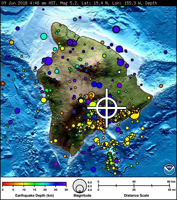
4:52 a.m.: NWS PACIFIC TSUNAMI WARNING CENTER MESSAGE
AN EARTHQUAKE HAS OCCURRED WITH THESE PRELIMINARY PARAMETERS
ORIGIN TIME – 0448 AM HST 09 JUN 2018
COORDINATES – 19.4 NORTH 155.3 WEST
LOCATION – IN THE SUMMIT REGION OF KILAUEA VOLCANO
MAGNITUDE – 5.2
NO TSUNAMI IS EXPECTED. HOWEVER, SOME AREAS MAY HAVE EXPERIENCED STRONG SHAKING.
Sponsored Content


