

UPDATE: Tropical Storm Calvin continues to track toward Hawai’i Islands, 1,150 miles east southeast of Hilo

Update at 5 p.m. on July 16: Tropical storm Calvin continues towards the Big Island with sustained winds of 60 mph as it continues on a west-northwest path at 17 mph, located 1,150 miles east southeast of Hilo.
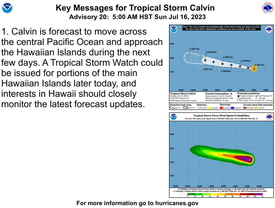
The National Weather Service said the center of Tropical Storm Calvin is expected to move “close to, or over, the islands” from Tuesday night through Wednesday night.
At 5 p.m., the center of Tropical Storm Calvin had winds that extended outward up to 90 miles from the center. The estimated minimum central pressure is 29.47 inches.

Storm total rainfall amounts of 4-7 inches are possible along windward areas of the Big Island of Hawaii from Tuesday night into Thursday, with lower amounts (1-4 inches) expected elsewhere in the state. This rainfall could lead to localized flash flooding and mudslides.
Swells generated by Calvin are expected to begin reaching the Hawaiian Islands during the next couple of days. These swells are likely to cause life-threatening surf and rip current conditions.
Keep checking back to www.bigislandnow.com for your latest weather updates.
_____________________________________________________________________________

Original story at 12:21 p.m. on July 16: The Hurricane Center is forecasting to issue a Tropical Storm Watch for the Island of Hawai’i within the next 24 hours.
The Hawai’i County Civil Defense reports the effects of a tropical storm can span hundreds of miles from its center. Tropical storm effects include high surf, high winds, and flooding rains.
Residents are encouraged to take the time now to review their family emergency plan and make sure emergency kit and supplies are prepared and ready; should this storm impact the island.
Original story at 11 a.m. on July 16: Calvin, which is now a tropical storm, continues towards the Big Island with sustained winds of 65 mph as it continues on a west northwest path at 16 mph, located 1,260 miles east southeast of Hilo.
The National Weather Service said the center of Tropical Storm Calvin is expected to move “close to, or over, the islands” from Tuesday night through Wednesday night.
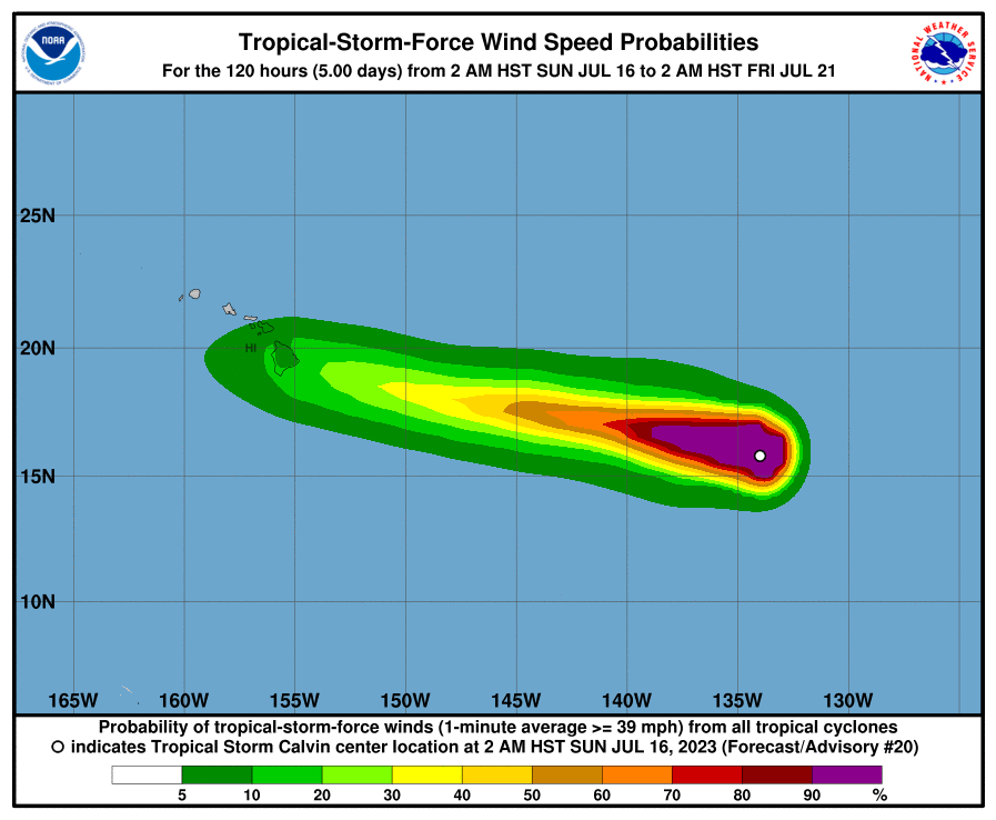
The forecast from the National Hurricane Center has consistently anticipated “tropical-storm-force winds in its northern semicircle” during its transit. They currently extend outward up to 90 miles from the center of the system.
Officials expect storm rainfall amounts of 4-6 inches are possible along windward areas of the Big Island on Wednesday and Thursday, with lower amounts (1-3 inches) expected elsewhere in the state. This rainfall could lead to localized flash flooding and mudslides.
Swells generated by Calvin are expected to begin reaching the Hawaiian Islands during the next couple of days. These swells are likely to cause life-threatening surf and rip current conditions.
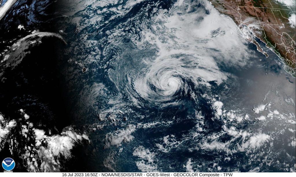
Original story at 5 a.m. on July 16: Calvin is now a tropical storm with sustained winds of 70 mph as it continues on a west northwest path at 16 mph, located 1,360 miles east southeast of Hilo.
The National Weather Service said the center of Tropical Storm Calvin is expected to move “close to, or over, the islands” from Tuesday night through Wednesday night.
The forecast from the National Hurricane Center has consistently anticipated “tropical-storm-force winds in its northern semicircle” during its transit. They currently extend outward up to 105 miles from the center of the system.
The storm potentially will bring a period of locally strong winds, heavy rain and high surf.
“Some uncertainty continues to exist with respect to the track and intensity forecast, and it is also important to remember that impactful weather can occur well away from the center,” the National Weather Service advised in its latest forecast.

“Calvin’s forward speed will be fairly quick when it is near the islands (toward the west at about 19 mph), so the amount of time any one island experiences gusty winds and heavy rainfall will be somewhat limited (probably on the order of 12-18 hours). However, the potential for extreme rainfall rates will likely warrant the issuance of a Flood Watch, which is usually done with about a 48 hour lead time,” according to the National Weather Service.
Based on the timeline, portions of the state could see watches issued later Sunday.
The latest National Hurricane Center forecast notes that swells generated by Calvin are expected to begin reaching the Hawaiian Islands during the next couple of days.
The National Weather Service is forecasting a return to a “typical trade wind weather pattern” from Thursday into next weekend as the remnants of Calvin move quickly west away from the islands, “likely as a trough.”
The National Hurricane Center reports that Calvin is expected to continue weakening during the next few days.
Sponsored Content


