

Mauna Loa Eruption Day 3: Planning underway for possible closure of Saddle Road

There’s a high probability that lava moving down the northeast flank of Mauna Loa could reach Daniel K. Inouye Highway — and possibly by the end of this week, according to an official with the Hawaiian Volcano Observatory.
If the lava crosses the highway, the effects would reverberate around the Big Island.
“Of course, [Daniel K. Inouye Highway] is a very important state highway,” said Hawai‘i County Civil Defense Administrator Talmadge Magno during a press conference Wednesday morning.
The thoroughfare from the east and west sides of the island through the saddle region between Mauna Loa and Maunakea is a key route used by thousands of people everyday, including government workers, business people and industry employees. Hele-On, the County’s public transportation system, also would lose the use of the highway.
The loss of that infrastructure, Magno said, would mean that traffic — which has increased as the island’s population has ticked up — would be forced to revert to using the main coastal highways around the island, Highways 11 and 19.
That would have multiple impacts, including places such as Hāmākua seeing an increase in the amount of traffic flowing through. And, already congested locations on the island would become even more overloaded. It also would mean instead of getting between the population centers of Hilo and Kailua-Kona in about an hour, it would take at least two and a half hours to make the trek.
Magno said discussions have begun with state emergency management officials about what they could provide for support if the highway is closed. Civil Defense also is talking with emergency medical services and officials at Hilo Medical Center and Kona Community Hospital about their plans.
The Hawai‘i Department of Transportation is monitoring the situation and coordinating with all of its partners at the county, state and federal levels in assessing the threat to the highway. Magno said that the state informed him that it would need at least six hours to shut the highway down if and when lava inundates it.
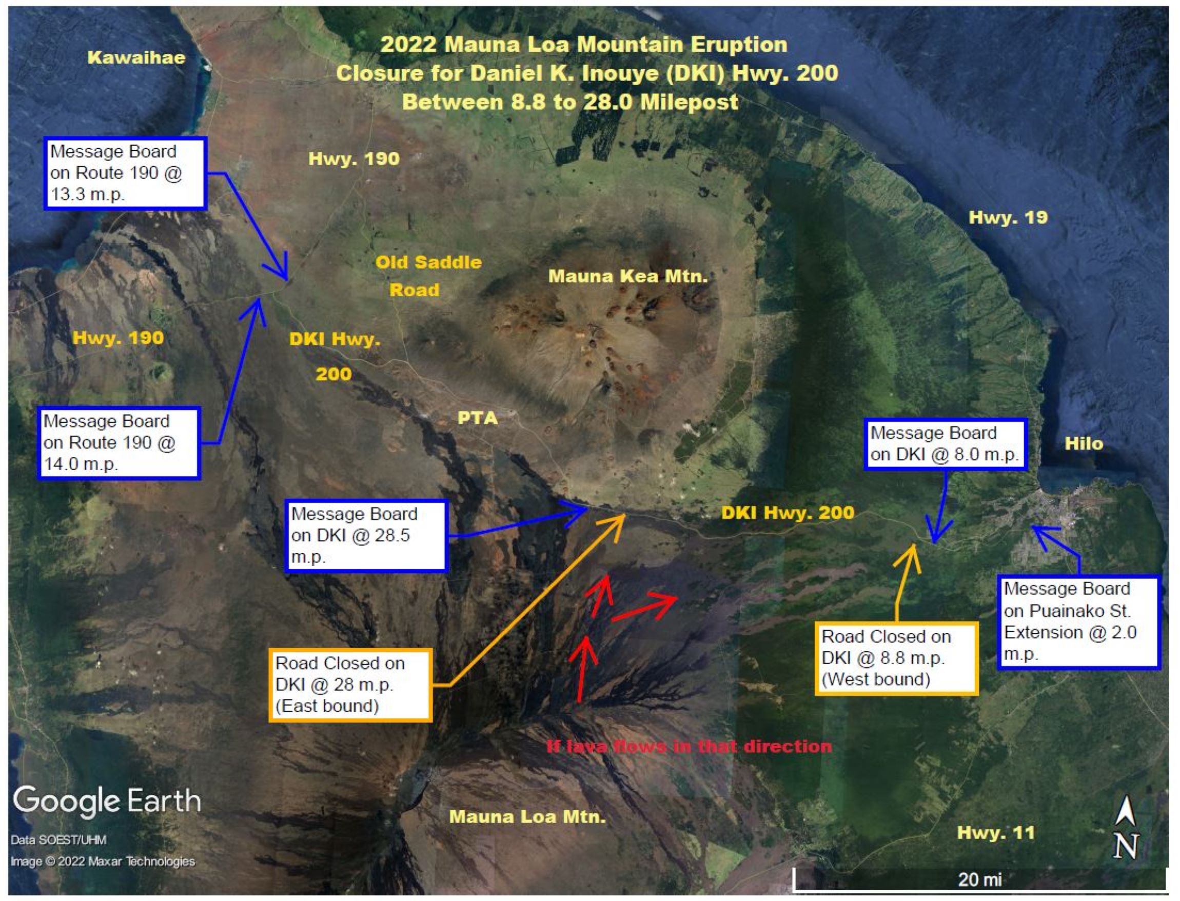
If it becomes necessary, the saddle road would be blocked off at the highway’s junction with Kaʻūmana Drive on the Hilo side of the island and at Gilbert Kahele Recreation Area on the Kona side, about a 25-mile stretch. The state would install several message boards along the highway, alerting motorists of the closure.
Magno said Civil Defense is in close contact with the Hawaiian Volcano Observatory on the timing for lava to reach and cross the highway. It also is discussing plans with all of its partners in the event the road must be closed.
If and when the lava flow crosses the highway, it will likely do so somewhere west of Puʻu Huluhulu. Hawaiian Volcano Observatory Scientist-in-Charge Ken Hon said during the press conference Wednesday that the lava would probably come around the north side of the volcanic cinder cone, right at the intersection with Maunakea Access Road, about 19 miles from where upper Kaʻūmana Drive in Hilo meets the highway.

Hon said if the leading edge of the principle flow from fissure 3 on Mauna Loa’s northeast flank continues moving at the 130 meters, or 0.08 miles, per hour rate measured Tuesday night, lava could reach the state highway by Friday.
“We expect it will probably take longer than that,” he said. “As the lava flow spreads out, it will probably interfere with its own progress and we expect it to slow down some from that previous rate. So we’re looking at about two days out at the earliest that it might actually hit the Saddle Road at this point.”
However, Hon said it’s not that the flow will hit the highway in two days, that’s just the fastest it could.
About 10 a.m. Wednesday, the lava flow was 3.6 miles from Daniel K. Inouye Highway. The lava is expected to slow down and begin to spread out now that it is moving into a flatter area of the mountain.
“We expect it to meander a fair amount out in there, to spread out; it also might inflate once it gets on the flat ground and store a lot of lava inside of it … ,” Hon said. “So there’s a lot of things that could change when it arrives and where it arrives.”
Right now, it’s a matter of waiting and watching.

Magno said there was a discussion Wednesday morning about possibly diverting the lava away from the highway. Civil Defense will be getting information from the U.S. Geological Survey about successful diversion attempts around the globe, but at this time there are no plans, mechanisms or timing in place for diverting the flow. Hon said lava diversion is a tricky thing, especially on flat ground.
“Take 10 of the biggest dump trucks you can think of — we’re getting that many dump trucks of lava every second delivered by this lava flow,” he said. “If you think you can pile up stuff in front of it faster than it can deliver stuff, you’re probably wrong. So it would be very hard to really effectively stop the lava from filling in the area it’s going to fill in. It’s just not an easy problem to solve.”
After the highway is covered by lava, it could be awhile before any plans of reopening it could begin.
“First thing we know, the lava will have to stop — the flow, the eruption will have to stop before anything is put in,” Magno said.
Using the 2018 eruption and lava flow from Kīlauea in lower Puna as an example, Magno said main routes were restored within months after the flow stopped. The state would be responsible and is already looking at how and when that will happen. He said the process to restore the highway or build something new would likely begin immediately after the eruption and flow stop.
The Hawaiian Volcano Observatory and Civil Defense continue to monitor the eruption and keep the public informed. For the latest news about the Mauna Loa eruption, click here. To see alerts from Civil Defense, click here.
Sponsored Content


