

Cat 2 Lane Heads North Toward Maui, O‘ahu
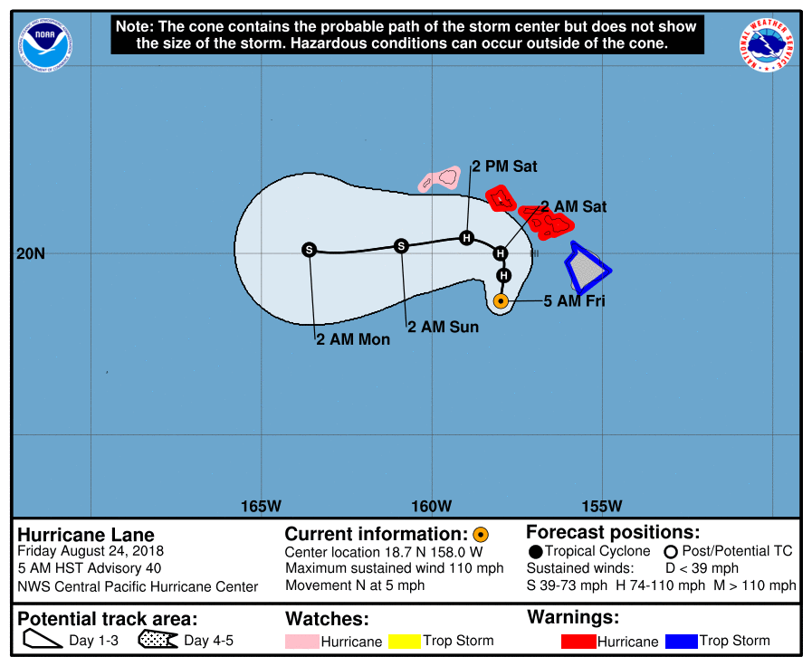
Hurricane Lane, Aug. 24, 2018, 5 a.m. NOAA
6 AM: Cat 2 Lane Heads North Toward Maui, O‘ahu
CURRENT WATCHES AND WARNINGS
A Hurricane Warning is in effect for Central O‘ahu, Haleakalā Summit, Kaho‘olawe, Lāna‘i makai, Lāna‘i mauka, leeward Haleakalā, Maui Central Valley, Maui leeward west, Maui windward west, Moloka‘i leeward, Moloka‘i windward, O‘ahu Ko‘olau, O‘ahu North Shore, O‘ahu South Shore, Olomana, Waianae Coast, Waianae Mountains and Windward Haleakalā
A Hurricane Watch is in effect for Kaua‘i leeward, Kaua‘i mountains, Kaua‘i windward and Ni‘ihau
A Tropical Storm Warning is in effect for Big Island interior, Big Island north and east, Big Island summits, Kohala, Kona and south Big Island
Hurricane Lane is a Category 2 storm this morning, with maximum sustained winds of 110 mph.
As of 5 a.m., Hurricane Lane was located 180 miles south of Honolulu and around 145 miles west-southwest of Kailua-Kona. Lane is moving slowly toward the north at 6 mph.
A slow northward motion is expected to continue today.
A turn toward the west is anticipated on Saturday, with an increase in forward speed.
On the latest forecast track, the center of Lane will move dangerously close to portions of the central Hawaiian islands later today and tonight.
Hurricane Lane, Aug. 24, 2018, 7:30 a.m.
Regardless of the hurricane track, life-threatening impacts will extend far beyond the center position as Lane approaches the islands.
Do not focus on the exact forecast track or intensity of Lane. The close proximity of this hurricane track to the main Hawaiian Islands and the forecast timing of Lane’s turn to the west remains challenging.
Be prepared for changes in future forecasts as Lane approaches the islands from the south. Although the official forecast does not explicitly indicate Lane’s center making landfall over any of the islands, impacts from a land falling hurricane may still occur.
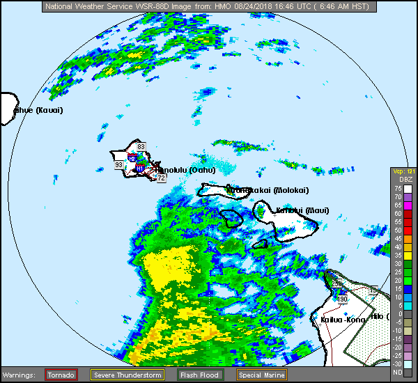
Tropical storm conditions are already occurring on the Big Island, Maui County and O‘ahu. These conditions will likely persist today.
Hurricane conditions are expected over some areas of Maui County and O‘ahu starting later today and continuing through tonight.
Tropical storm or hurricane conditions are possible on Kaua‘i starting tonight or Saturday.
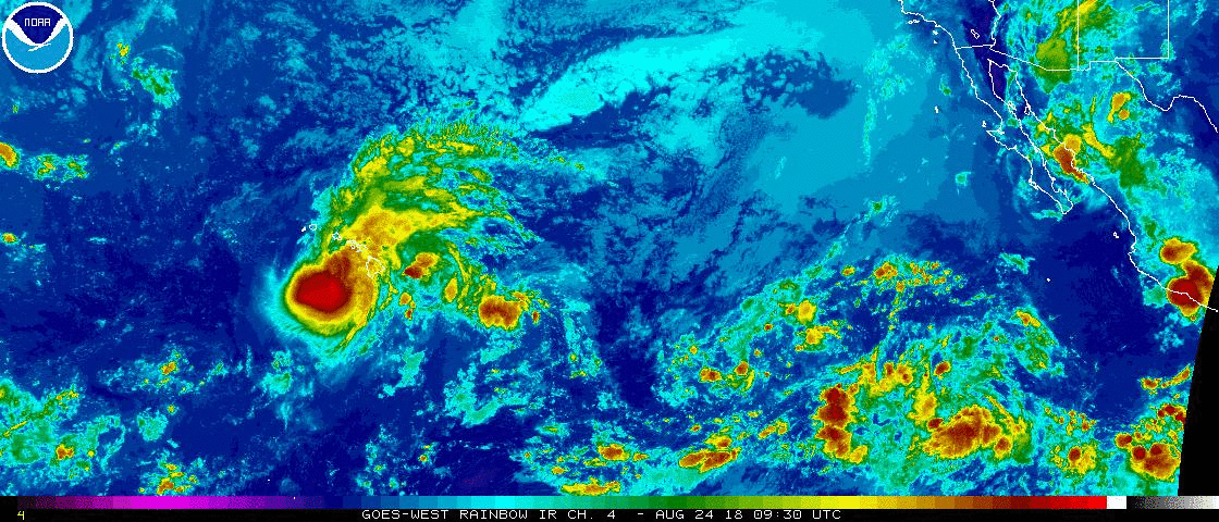
Hurricane Lane, Aug. 24, 2018, 6:30 a.m. NOAA
Rain bands will continue to overspread the Hawaiian Islands well ahead of Lane. Excessive rainfall associated with this slow moving hurricane will continue to impact the Hawaiian Islands into the weekend, leading to catastrophic and life-threatening flash flooding and landslides.
Lane is expected to produce total rainfall accumulations of 10 to 20 inches, with localized amounts up to 40 inches possible. Over 30 inches of rain have already fallen at a couple locations on the windward side of the Big Island over the past 36 hours.
Swells generated by Lane will produce life-threatening surf and dangerous rip currents along exposed shores of all Hawaiian Islands. A prolonged period of high surf will likely lead to significant coastal
erosion. Surf is expected to continue to increase through the day today with the peak tonight as Lane passes near the smaller islands. Surf heights for the Big Island are forecast from 10 to 15 feet along the SW facing shores, with 6 to 10 feet for east-facing shores. Surf heights for Maui County, O‘ahu and Kaua‘i County will rise 15 to 25 feet by this afternoon.
The combination of storm surge and large breaking waves are expected to raise water levels well above normal tide levels as Hurricane Lane makes its closest approach. Overwash onto vulnerable coastal roadways will be possible through Saturday, especially around the afternoon high tide cycles. Water levels will rise 2 to 4 feet above normal along south- and west-facing shores near the center of Lane.
Tornadoes and large waterspouts will be possible with Lane.
Do not enter evacuated areas until officials have given the all clear to return.
OTHER PREPAREDNESS INFORMATION
Now is the time to complete all preparations to protect life and property in accordance with your emergency plan. Ensure you are in a safe location before the onset of strong winds or possible flooding.
If you are relocating to safe shelter, leave as early as possible. Allow extra time to reach your destination.
Many roads and bridges will be closed once strong winds arrive.
Check the latest weather forecast before departing and drive with caution.
Failure to adequately shelter may result in serious injury or loss of life. Always heed the advice of local officials and comply with any orders that are issued. Remember, during the storm 9 1 1 Emergency Services may not be able to immediately respond if conditions are unsafe. This should be a big factor in your decision making.
Keep cell phones well charged. Cell phone chargers for automobiles can be helpful, but be aware of your risk for deadly carbon monoxide poisoning if your car is left idling in a garage or other poorly ventilated area.
It is important to remain calm, informed, and focused during an emergency. Be patient and helpful with those you encounter.
If you are a visitor, be sure to know the name of the city or town in which you are staying and the name of the county or parish in which it resides. Listen for these locations in local news updates. Pay attention for instructions from local authorities.
Storm surge is the leading killer associated with tropical storms and hurricanes! Make sure you are in a safe area away from the surge zone. Even if you are not in a surge-prone area, you could find yourself cutoff by flood waters during and after the storm. Heed evacuation orders issued by the local authorities.
Rapidly rising flood waters are deadly. If you are in a flood-prone area, consider moving to higher ground. Never drive through a flooded roadway. Remember, turn around don’t drown!
If in a place that is vulnerable to high wind, such as near large trees, a manufactured home, upper floors of a high-rise building, or on a boat, consider moving to a safer shelter before the onset of
strong winds or flooding.
Closely monitor weather.gov, NOAA Weather radio or local news outlets for official storm information. Be ready to adapt to possible changes to the forecast. Ensure you have multiple ways to receive weather warnings.
ADDITIONAL SOURCES OF INFORMATION:
For information on appropriate preparations see ready.gov
For information on creating an emergency plan see getagameplan.org
For additional disaster preparedness information see redcross.org
NEXT UPDATE
The next local statement will be issued by the National Weather Service in Honolulu around noon, or sooner if conditions warrant.
Sponsored Content


