2006 Earthquakes Spurred Monitoring Improvements

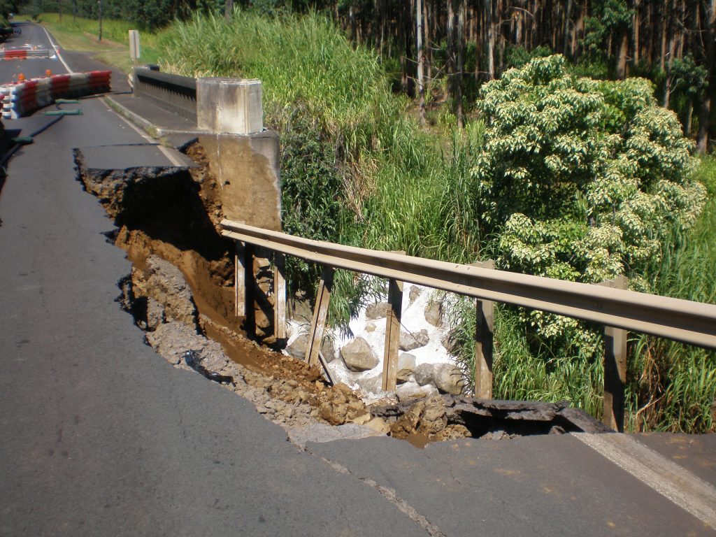
Damage along Hawaii Belt Road at Kawaili Bridge, near Pa‘auilo, following the Kīholo Bay and Māhukona earthquakes of Oct. 15, 2006. USGS photo.
Ten years ago, shortly after 7 a.m. on Sunday, Oct. 15, 2006, two damaging earthquakes struck off the northwest coast of the Island of Hawai‘i—a magnitude-6.7 earthquake beneath Kīholo Bay and a magnitude-6.0 earthquake offshore of Māhukona.
The earthquakes damaged roads and buildings and impacted utilities in the Kohala, Kona and Hāmākua Districts of Hawai‘i County and on the eastern side of Maui. O‘ahu experienced a major power outage. The impacts might have been far worse if the earthquakes had struck on a weekday.
When USGS and Pacific Tsunami Warning Center seismologists saw the signals from the Kīholo Bay earthquake, it was immediately clear the signals were much larger than the thousands of microearthquakes that occur each year. Their immediate questions were, “How large was the earthquake?” and “Would there be a damaging tsunami?”
In 2006, seismic monitoring across the United States was already computer-based; data were transmitted from remote field sites and collected at seismographic monitoring centers and then converted into computer-ready formats. The USGS had initiated its Advanced National Seismic System project to modernize earthquake monitoring in the nation. Older field instruments were gradually being replaced with units that streamed digital data—computer-ready signals—to regional and national earthquake processing centers.
At the time, three seismic stations on the Island of Hawai‘i had been outfitted with digital instruments as part of an upgrade to improve US tsunami warning capabilities. A handful of other seismic stations had already been upgraded with digital units as part of the initiative to resolve the Year 2000 Problem (Y2K). Although staff at the USGS’s Hawaiian Volcano Observatory assisted with these upgrades, these units were not yet fully integrated with HVO’s volcano-monitoring network.
Within minutes of the Kīholo Bay earthquake, seismologists verified that it was deep, roughly 25 miles. Although the earthquake shook HVO instruments beyond their operating range, data from the tsunami-upgraded instruments on the Island of Hawai‘i yielded the first estimate of magnitude-6.6 as determined by PTWC.
Several minutes later, after telephone calls among seismologists at PTWC, HVO and the USGS’s National Earthquake Information Center in Colorado, a consensus was reached of magnitude-6.7. Based on earthquake depth and magnitude, PTWC confirmed that there was no tsunami threat from the earthquake.
The Y2K-upgraded stations were not equipped to transmit data in real-time, but they nevertheless provided important information about the earthquake. These instruments recorded even the strongest shaking of both earthquakes. With this data, USGS seismologists in Colorado created ShakeMaps to show how shaking from the earthquakes varied from place to place.
Such information, along with the Kīholo Bay “Did You Feel It? Community Internet Intensity Map,” guided and informed post-earthquake surveys of potential damage and other effects as recovery efforts began.
A USGS assessment in the aftermath of the 2006 earthquakes recognized the need to integrate more modern digital instruments and analysis systems into HVO’s earthquake monitoring program. For example, in order analyze in real time data from the new digital field instruments, a new ANSS Quake Management Software (AQMS) system developed and used in California was needed at HVO (installed in 2009).
Subsequently, with support from the American Reinvestment and Recovery Act of 2009, HVO modernized all seismic field instruments and radio systems. Simply put, HVO now records all earthquakes of interest beneath the Island of Hawai‘i with the means to automatically generate state-of-the-art earthquake information products. Important work continues to maintain the instruments and radio systems, and also to improve the automated and rapid delivery of reliable earthquake information.
These improvements will help in the analysis of future large-magnitude earthquakes and in understanding and anticipating their impacts.
The 10 years since the Kīholo Bay and Māhukona earthquakes have brought many new residents to Hawai‘i’s earthquake country. Most of our elementary school students probably have no direct recollections of the 2006 earthquakes. Next week’s annual Great Hawaii ShakeOut drill to practice Drop! Cover! and Hold On! is a reminder to everyone about Hawai‘i’s earthquake history and how to prepare for and recover from future earthquakes.
The Great Hawaii ShakeOut takes place at 10 a.m., HST, on Thursday, Oct. 20, 2016.
For more detailed information about earthquake preparedness, visit the Great Hawaii ShakeOut website ().
Volcano Activity Updates
Kīlauea continues to erupt at its summit and East Rift Zone. This past week, the summit lava lake level raised in concert with summit inflation, from a low of about 171 feet to as high as 39 feet below the vent rim within Halema‘uma‘u Crater. The 61g lava flow continued to enter the ocean near Kamokuna. The lava flow does not pose an immediate threat to nearby communities.
Mauna Loa is not erupting. Seismicity remains elevated relative to the long-term background rate, with small earthquakes occurring mostly in the volcano’s south caldera and upper Southwest Rift Zone at depths less than 3 miles. Global Positioning System measurements show deformation related to inflation of a magma reservoir beneath the summit and upper Southwest Rift Zone.
Two earthquakes were felt on the Island of Hawai`i in the past week. On Friday, Oct. 7, at 2:21 p.m., HST, a magnitude-3.2 earthquake occurred 7.4 miles southeast of Honoka‘a at a depth of 5.6 miles. On Sunday, Oct. 9, at 3:44 a.m., HST, a magnitude-3.9 earthquake occurred 9.3 miles east of Leilani Estates at a depth of 8.1 miles).
Volcano Watch is a weekly article and activity update written by U.S. Geological Survey Hawaiian Volcano Observatory scientists and affiliates.
Call for summary updates at (808) 967-8862 (Kīlauea) or (808) 967-8866 (Mauna Loa); email questions to [email protected].


