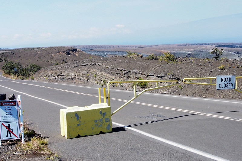
Layers of explosive deposits erupted from Kīlauea Volcano in 17th and 18th centuries are visible in a road cut just beyond the gate at Keanakākoʻi Crater. This section of Crater Rim Drive has been closed since 2008, when the still-erupting vent within Halemaʻumaʻu Crater (middle, far right) first opened. USGS photo.
You enter Hawaiʻi Volcanoes National Park and drive past Kīlauea Visitor Center, perhaps first stopping for guidance on where to see lava—the reason most people visit the volcano. Eventually you cross Steaming Flat, drive by Kilauea Military Camp (KMC), and arrive at the Jaggar Museum parking lot. You park and walk to the viewing platform, hoping that lava is visible in the distant Halemaʻumaʻu Crater.
As an observant visitor, though, you may have noted something a bit strange. You saw lava flows—cold and solidified, of course—only in cuts where the road drops down to, and then climbs out of Steaming Flat. Everywhere else, you were traveling on a surface of gravelly or sandy material (hidden by vegetation in many places). Volcanologists call this material tephra, a product of explosive eruptions. The tephra sits on, and mostly hides, the lava flows of Kīlauea.
Before 2008, the year when Crater Rim Drive was closed at Jaggar Museum, your drive into and across the caldera would have been similar. Tephra is everywhere at the ground surface, except where lava flows that were erupted in the late 20th century cross the road. Large blocks and pockets of ash that exploded from Halema‘uma‘u in 1924 litter the surface surrounding the crater.
Today, you can observe tephra by walking along the section of Crater Rim Drive between the Devastation Trail parking area and Keanakākoʻi Crater. Thick deposits of pumice and scoria from the 1959 Kīlauea Iki lava fountains line much of the hiking route. Near Keanakākoʻi, layered older explosive deposits are evident, particularly visible in the cut (closed to visitors) just beyond the gate at Keanakākoʻi.
ARTICLE CONTINUES BELOW AD
ARTICLE CONTINUES BELOW AD
By now, you’ve found some of the evidence for past explosive eruptions that geologists a century ago recognized. They correctly surmised that many explosions, not just one, had occurred, because they found evidence of erosion between some layers within the deposits. They knew that at least one eruption took place in 1790, but had no way of knowing when the others occurred.
In the late 1960s, observations of erupting Taal Volcano, Philippines, led to the recognition of base surges, which carry hot volcanic debris across the surface at hurricane velocity. Volcanologists soon discovered that surges can erode the ground surface, scouring channels much like those eroded by water and wind.
Base-surge deposits were identified at Kīlauea in the early 1970s—an important step in understanding its past explosive history. But there was a detour along the way. Surges were the “in” thing then, and they were used to account for all the erosional features found in the explosive deposits. With this thinking, one no longer needed to postulate many explosions, separated by periods of wind and water erosion. Instead, repeated scouring by multiple surges during only one eruption in 1790 became the favored model.
In the 1990s, a new technique for radiocarbon dating—accelerator mass spectrometry (AMS)—made it possible to measure the age of only a few milligrams of charcoal resulting from fires set by lava flows and explosive eruptions. That remarkable technological advancement, coupled with a means to adjust the AMS ages to calendar years, opened the door to understanding much of Kīlauea’s past few thousand years.
ARTICLE CONTINUES BELOW AD
Application of AMS dating to the explosive deposits found that multiple eruptions of different ages had indeed taken place, and that water and wind erosion was responsible for some of the channels and irregular surfaces found in the deposits. To be sure, surges did some of the erosion, but not all.
This discovery freed our thinking; no longer was it necessary to cram all the explosive activity into one year. The new “relaxed-fit” approach fits the data better, indicating about 300 years of repeated explosive eruptions at Kīlauea’s summit. Detailed field work found more evidence supporting the new interpretation. The story now is internally consistent.
Your drive from the Park entrance station to Jaggar Museum, and your walk at Keanakākoʻi Crater, are on deposits of the 1790 eruption, which overlie older deposits going back to about 1500. Other research has found evidence for older periods of explosive activity lasting as long as 1200 years. The bottom line: Kīlauea is an explosive volcano that will, almost certainly, explode again.
Volcano Activity Updates
ARTICLE CONTINUES BELOW AD
Kīlauea continues to erupt at its summit and East Rift Zone. During the past week, the summit lava lake level varied between about 30 and 48 m (98–157 ft) below the vent rim within Halema‘uma‘u Crater. On the East Rift Zone, scattered lava flow activity remained within about 5.7 km (3.5 mi) northeast of Puʻu ʻŌʻō and was not threatening nearby communities.
Mauna Loa is not erupting. Seismicity remains elevated above long-term background levels, but no significant changes were recorded over the past week. Deformation related to inflation of a magma reservoir beneath the summit and upper Southwest Rift Zone continues, with inflation recently occurring mainly in the southwestern part of Mauna Loa’s magma storage complex.
No earthquakes were reported felt on the Island of Hawai‘i this past week.
Volcano Watch is a weekly article and activity update written by scientists at the U.S. Geological Survey`s Hawaiian Volcano Observatory.
This comments section is a public community forum for the purpose of free expression. Although Big Island Now encourages respectful communication only, some content may be considered offensive. Please view at your own discretion. View Comments