State Releases Master Plan for Kiholo Bay Park
A draft master plan for Kiholo Bay would re-designate it from a state park reserve to a wilderness park.
This is despite the fact that there are currently about a half-dozen homes lining the North Kona bay, and a variety of other private holdings elsewhere on the the Kiholo Bay State Park Reserve’s eight miles of coastline.
The state park reserve established in 2002 contains 4,362 acres extending from the shore to the highway. It also includes 42 miles of hiking trails, and its coastline features not only Kiholo Bay but also Ohiki Bay, Keawaiki Bay and a portion of Anaeho`omalu Bay.
A “Pre-Final” master plan and draft environmental assessment released late last month said the Division of State Parks decided to declare the area a wilderness to “emphasize a careful balance between public demand for recreational space and sustainable management of natural and cultural resources.”
“The park environment and amenities will provide the community and visitors with recreational resources while preserving and protecting the natural and cultural heritage of the area for future generations,” the document said.
It said access to many areas of the park “will remain unimproved or be carefully managed for low impact, with minimal modification to the landscape.”
The document noted that the variety of archaeological sites in the area include numerous lava tubes or caves. Some contain human remains, and the document suggested that park-goers could be encouraged to visit those that are “least sensitive” to divert them from the most-sensitive ones, which would likely be closed or gated.

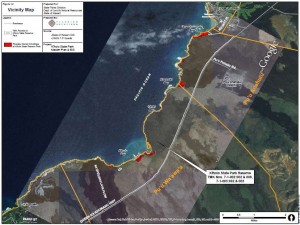
Location of private holdings (in red) and other coastline features are shown (click to enlarge). Image from Kiholo State Park Pre-Final Master Plan and Draft Environmental Assessment.
The document considers three alternate scenarios, with one known as the “focused camping” option calling for at least one campground and parking lot and a new access road into the park from the Queen Ka`ahumanu Highway. A second alternative calls for additional access and camping at Keawaiki Bay to the north, while the third would keep it as a park reserve.
There are currently eight campsites at Kiholo Bay’s southern end which hosted a total of 1,861 campers during fiscal year 2012. About 85% of those were Big Island residents, the document said.
The demand for campsites exceeds current capacity, the document said.
Under the first alternative for the proposed Kiholo State Wilderness Park, up to 10 additional campsites could be established at Kiholo Bay, with some located north and some south of the former Loretta Lynn house.
The state acquired the house and its property through a land swap with Kiholo Bay resident Earl Bakken a dozen years ago.
Restroom facilities – to replace the portable toilets currently provided – would be needed under the plan’s camping alternatives. Because no water supply is available, they would likely be either chemical or composing toilets.
Comments on the draft plan and study can be submitted to the Division of State Parks at PO Box 621, Honolulu, HI 96809 and to the consultant, Planning Solutions Inc. at 210 Ward Ave., Suite 330, Honolulu, HI 96814. The deadline is Oct. 8.


