

NOAA-Certified Data Now Available to Researchers, Mariners
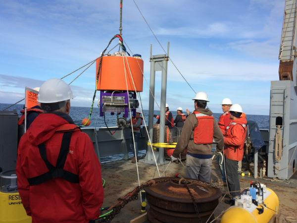
A joint deployment of a environmental sensor processor off the Washington coast by NOAA and the Northwest Association of Networked Ocean Observing Systems, one of the certified IOOS regional associations. The sensor has a special sampling package on board designed to detect early signs of harmful algal blooms (HABs). PC: Stephanie Moore/NOAA NW Fisheries Science Center.
The National Oceanic and Atmospheric Administration (NOAA) has announced it has certified the last of 11 Integrated Ocean Observing System (IOOS) regional associations as Regional Information Coordination Entities. The 11 regional associations cover most of the U.S. coastal zone in the Atlantic and Pacific oceans, and the Great Lakes.
Incoming data from all IOOS partners now adheres to common federal collection, storage and management standards and can be integrated with other data enabling further research and development possibilities. The data and tools offered through these regional associations will be backed by the reliability of sources like NOAA. As a result, scientists managers and businesses can directly access and use this data without spending time and resources assessing its quality.
“These certified IOOS regions make an important contribution to our nation’s Blue Economy, a top priority for NOAA,” said retired Navy Rear Admiral Tim Gallaudet, Ph.D., assistant secretary of commerce for oceans and atmosphere and acting under secretary of commerce for oceans and atmosphere. “This comprehensive, trusted, stakeholder-driven data aids navigation, fishing and aquaculture, weather forecasting and much more.”
Data from NOAA-certified IOOS associations is used in a variety of ways:
- The U.S. Coast Guard uses certified data from buoys and high frequency radar data to aid in search and rescue;
- Port authorities around the nation use real-time data from buoys, current meters, tide gauges and high frequency radars to safely guide cargo ships in and out of harbors;
- Emergency responders use current, wave and wind data to respond to hazardous materials spills, and to help forecast where oil, sewage and other materials will flow;
- Researchers from NOAA and partners use data from IOOS undersea gliders to research how hurricanes grow in strength, which will help make hurricane forecasts more accurate.
“The regional associations are at the very core of IOOS,” said U.S. IOOS director Carl G. Gouldman. “Their community ties and local expertise are essential for keeping the national system performing for all users. Completing the certification process allows all users to directly benefit from these great resources and strengthens the relationship between regional and national interests.”
IOOS is a coordinated network of regional associations that compile and distribute data on America’s coastal waters, Great Lakes and oceans. IOOS coastal and marine data, such as water temperature, water level, currents, winds, and waves, are collected by many different tools including satellites, buoys, tide gauges, radar stations, animal tags and underwater vehicles.

Physical and biological ocean information flows to the IOOS network from a diverse range of sources and advanced technologies. PC: NOAA.
Learn more about NOAA’s IOOS program online at https://ioos.noaa.gov/.
Sponsored Content


