

10 PM: Reports of Spattering at Fissures 6 and 13
Video from helicopter overflight of Kīlauea Volcano’s lower East Rift Zone on June 4, 2018, shows lava from fissure 8 entering the ocean at Kapoho Bay. View to the north.
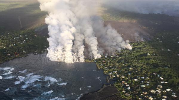
Overflight photograph at approximately 6:13 a.m., June 4, 2018, shows the lava flow originating from Fissure 8 (not visible in photograph) entering Kapoho Bay. The ocean entry was reported to have occurred by 10:30 p.m. on the night of June 3, 2018.
This news story will be updated throughout the day as new information becomes available and new articles will be added to the website’s “News” section. Previous information about ongoing events can be found in Big Island Now’s “Volcano Blog” section.
Monday, June 4, 2018, 10 p.m.: Lava in Kapoho Bay extending approximately 750 yards from shore
Fountaining at Fissure 8 continues to feed a robust channel transporting lava to the northeast along Highway 132 and east to the ocean entry in Kapoho Bay.

Photo: View of Fissure 8 from Leilani Street at about 8:45 p.m. on June 4, 2018.
Multiple observations from field crews and overflights suggest the Fissure 8 fountain is less vigorous this evening, with maximum heights of 130 to 160 feet.
As of early evening, lava was filling Kapoho Bay, extending out approximately 750 yards from shore. A laze plume is blowing inland from the ocean entry but is dissipating quickly.
The lava breakout on the north side of the Kapoho cinder pits continues to be stalled southeast of the intersection of Railroad Avenue and Cinder Road. A lava breakout from the south margin of the flow near the intersection of Highway 132 and Railroad Avenue has completely encircled the Green Lake cone.
Sluggish lava flows are present in the vicinity of Fissure 18, and there are reports of spattering at Fissures 6 and 13. All other fissures are inactive.
SUMMIT
Earthquake activity at the summit was low after Sunday’s small explosion, but has slowly increased since that time. Levels are approaching those of Sunday early afternoon, before the most recent small explosion. Inward slumping of the rim and walls of Halema‘uma‘u continues in response to persistent subsidence. We expect that earthquake rates will increase in the coming hours and culminate in another small explosion, perhaps within the next day, following the pattern of the past few weeks.
Over the last week, sulfur dioxide passively degassing from the volcano’s summit has decreased, but emission rates remain high enough to impact air quality in downwind regions. Additional bursts of gas released with intermittent explosive activity are also transported downwind and may temporarily affect air quality as well.
6 p.m.: Laze plumes continue
Hawaiian Volcano Observatory reports that vigorous lava eruptions continue in the lower East Rift Zone. Fissure 8 is very active and producing a large channelized flow that is filling in Kapoho Bay.
The ocean entry is sending a large plume into the air along the coastline.
Due to the lava entering the ocean, the following policies are in effect:
- Laze is formed when hot lava hits the ocean sending hydrochloric acid and steam with tiny glass particles into the air.
- Be aware of the laze hazard and stay away from any ocean plume.
- Health hazards of laze include lung damage, and eye and skin irritation.
- Be aware that the laze plume travels with the wind and can change direction without warning.
Due to the current volcanic activity, the following policies are in effect:
- Government Beach Road, between Kahakai Boulevard and Cinder Road, is open to Wa‘a Wa‘a and Papaya Farms Road residents only with official credentials. There is no curfew.
- Residents in this area should heed warnings from Civil Defense officials and be prepared to evacuate with little notice.
- The shelter at Pāhoa Community Center is open and pet-friendly. The Keaau Armory shelter has reached capacity.
An eruption community information meeting will be held at the Pāhoa High School cafeteria tomorrow, Tuesday, May 5 at 5 p.m.
3 p.m.: Civil Defense Video Update
https://www.facebook.com/BigIslandNow/videos/1675884722489070/
11:30 a.m.
Hawaiian Volcano Observatory reports that Fissure 8 continues to feed a large channelized flow that entered the ocean in Kapoho Bay last night. The ocean entry remains active and is currently a half-mile wide. The flow is sending a large laze plume into the air along the coastline.
Hawaiian Volcano Observatory reports parts of the channelized flow from Fissure 8 are starting to break out and move north, approaching Wa‘a Wa‘a and Papaya Farms Road.
Due to the current volcanic activity, the following policies are in effect:
- There is no access to the lower Puna area, Highway 132, and Highway 137 due to lava inundation.
- Government Beach Road, between Kahakai Boulevard and Cinder Road, is open to Waa Waa and Papaya Farms Road residents only with official credentials. There is no curfew.
- Residents in this area should heed warnings from Civil Defense officials and be prepared to evacuate with little notice.
11 a.m.: EPA Air Quality Readings on Big Island

Kona: Unhealthy for sensitive groups.
The general public is not likely to be affected at this AQI range; however, people with lung disease, older adults and children are at greater risk from the presence of particles in the air.
Ocean View: AQI: Unhealthy for everyone. Everyone may begin to experience health effects members of sensitive groups may experience more serious health effects.
For updates, click here.
11 a.m.: Kīlauea Media Briefing from June 3
USGS seismologist
Jessica Ferricane, public affairs officer, Hawaiian Volcanoes National Park
NWS forcaster
10:45 a.m.: USGS Status Update of Kīlauea Volcano
Jessica Ball, USGS volcanologist
VIDEO TRANSCRIPT
Starting in the Lower East Rift Zone, as of 10:30 p.m. last night, the front of the Fissure 8 lava flow had entered the ocean at Kapoho. Laze (lava haze) and steam explosions are expected, as with the Fissure 18 ocean entry.
Fissure 8 remains active with a vigorous lava fountain up to heights of 220 feet and a wide perched lava channel.
Small outbreaks of lava should be expected along the length of the channel, and there is a breakout north of the Kapoho Cinder Pit near the intersection of Cinder and Railroad.
As of 6 p.m. on June 3, lava had covered 7.7 square miles or 4,917 acres.
At the summit, an explosion from the Halema’uma’u Crater at 3:50 p.m. registered as a magnitude 5.5 earthquake and produced an ash plume to an estimated height of 8,000 feet.
Continued crater collapses, explosions (some registering as earthquakes), ash plumes and degassing should be expected.
8:49 a.m. HAWAIIAN VOLCANO OBSERVATORY STATUS REPORT
Current Volcano Alert Level: WARNING
Current Aviation Color Code: RED
Kīlauea Volcano Lower East Rift Zone
Vigorous eruption of lava continues from the lower East Rift Zone (LERZ) fissure system in the area of Leilani Estates and Lanipuna Gardens.
Fountaining at Fissure 8 continued overnight, feeding a robust lava channel to northeast along Highway 132 to the Kapoho area. Local videographers reported that lava entered the ocean at Kapoho Bay at about 10:30 p.m. on June 3.
As of 6:30 a.m. June 4, lava is constructing a delta in Kapoho Bay extending a few hundred yards into the bay.
A laze plume is blowing inland from the ocean entry but dissipating quickly. The lava flow front is about .5 miles wide. A lava breakout is also occurring upslope of the Kapoho cone cinder pit, with active flows about 330 yards southeast of the intersection of Railroad Avenue and Cinder Road.
Sluggish lava flows are present in the vicinity of Fissure 18; all other fissures are inactive.
Pele’s Hair and other lightweight volcanic glass from high fountaining of Fissure 8 are falling downwind of the fissure and accumulating on the ground within Leilani Estates. Winds may waft lighter particles to greater distances. Residents are urged to minimize exposure to these volcanic particles, which can cause skin and eye irritation similar to volcanic ash.
HVO field crews are on site tracking the fountains, lava flows, and spattering from multiple fissures as conditions allow and are reporting information to Hawaii County Civil Defense.
Volcanic gas emissions remain very high from the fissure eruptions. Trade wind conditions are bringing vog to the south and west sides of the Island of Hawaii. Afternoon easterly winds may bring vog to communities in the Volcano area.
Magma continues to be supplied to the lower East Rift Zone. Earthquake locations have not moved farther downrift in the past few days and the number of located earthquakes remains low. Seismicity remains relatively low with numerous small magnitude earthquakes and low amplitude background tremor.
Additional ground cracking and outbreaks of lava in the area of the active fissures are possible. Residents downslope of the region of fissures should heed all Hawaii County Civil Defense messages and warnings.
USGS/HVO continues to monitor the lower East Rift Zone activity 24/7 in coordination with Hawaii County Civil Defense.
Kīlauea Volcano Summit
Following the small explosion at about 3:50 p.m. on June 3, earthquake activity at the summit has been low. Inward slumping of the rim and walls of Halema‘uma‘u continues in response to persistent subsidence. We expect that earthquake rates may increase in the coming hours to days and culminate in another small explosion, following the pattern of the past few weeks.
Volcanic gas emissions at the summit remain high.
For forecasts of where ash would fall under forecast wind conditions, please consult the Ash3D model output here.
Information on volcanic ash hazards and how to prepare for ash fall maybe found here (health impacts) OR here (other impacts).

Leilani Estates, Hawai‘i Island, Restricted Evacuation Zone from Pomaikai and Leilani Avenue, June 3, 2018, 7:30 p.m. PC: Scott Cate
6 a.m.: Lava entered Kapoho Bay
Hawaiian Volcano Observatory reports that Fissure 8 continues to feed a large channelized flow traveling along Highway 132, the Pāhoa-Kapoho Road.
Lava entered the ocean in Kapoho Bay last night.

Kīlauea Lower East Rift Zone lava flows and fissures, June 3, 11a.m. Given the dynamic nature of Kīlauea’s lower East Rift Zone eruption, with changing vent locations, fissures starting and stopping, and varying rates of lava effusion, map details shown here are accurate as of the date/time noted. Shaded purple areas indicate lava flows erupted in 1840, 1955, 1960 and 2014-2015. (Click to see large map.)
Due to lava crossing Highway 137, the following policies are in effect:
- There is no access to the lower Puna area, Highway 132, and Highway 137 due to lava inundation.
- Contact Civil Defense if you confirm that someone you know is remaining in the isolated area. Call 935-0031.
Highway 130 on June 1, 2018. PC: Crystal Richard
On roadways:
- Government Beach Road, between Kahakai Boulevard and Cinder Road, is open to Wa‘a Wa‘a and Papaya Farms Road residents only with official credentials. There is no curfew.
- Volcanic gas emissions remain high at the KĪlauea summit and in the fissure system. Residents in communities downwind should take action to limit exposure to gas and ash.
- On the coast, be aware of hydrochloric acid and glass particulates from the laze at the ocean entry.
Stay alert to warnings from Civil Defense officials and be prepared to evacuate with little notice.
Shelters at Pahoa Community Center and Kea’au Armory are open and pet friendly.

Fissure 8 flow front: Photo from 7 a.m. helicopter overflight on June 3, 2018, hovering offshore and looking up the flowfront. Nearly all of the front was active and advancing; advance rates were estimated at an average of 250 feet/hour (76 m/hr), and as of 7AM the flow was 500 yards (457 m) from the ocean.
https://www.facebook.com/BigIslandNow/videos/1675724019171807/
Pohoiki Road Lava Progression

Pohoiki Road comparison: (L) June 2 and (R) May 28. PC: Crystal Richard
On May 28, a small finger of pāhoehoe lava crossed Pohoiki Road. Just five, on June 2, 2018, a 30-foot wall of ‘a‘a blocks Pohoiki Road in addition to two small fingers of pāhoehoe.
Both photos were taken from the 35 mph sign on Pohoiki Road.

The lava river coming off of Fissure 8, which is glowing in the trees on the righthand side from Leilani Avenue and Pomaikai Street on June 3, 2018, at 7:18 p.m. PC: Crystal Richard.
Sponsored Content


