

Kīlauea Lava Lake Explosion: Reminder of Ongoing Hazards
This week’s “Volcano Watch” highlights the significant, ongoing, inherent hazards associated with Kīlauea summit’s Halemaʻumaʻu Crater lava lake.
At 10:02 p.m., HST, on Saturday, Aug. 6, a section of altered, thermally-stressed rock enclosing the Halemaʻumaʻu Crater lava lake detached from the vent wall and plummeted into the molten lava.
Tons of rocky debris impacting the lake surface triggered a violent explosion of volcanic gas, incandescent spatter (blobs of molten lava) and pieces of solid rock that sent a jet of glowing debris skyward.
Within seconds, tephra (airborne volcanic rock fragments) began falling to the ground, blanketing the rim of Halemaʻumaʻu Crater—about 120 m (400 feet) above the lava lake surface—with a continuous layer of spatter and dense rock fragments that covered an area of about 50 m by 80 m (165 feet by 260 feet).
In places, this tephra layer was up to 20 cm (8 inches) thick. Almost certainly, anyone who had been near the crater rim in this area would have been killed or severely injured.
Trade winds influenced the trajectory of the fallout. So, while most of the tephra fell just east of the vent, pebble-sized debris also pelted the Halemaʻumaʻu Crater parking lot, about 500 m (.3 miles) to the southwest.
As testimony to the heat and violence of the event, images captured two days later show the blanket of spatter and solid rock fragments, with individual pieces up to 70 cm (28 inches) across, on the crater rim.
Spatter that landed on a plastic case housing batteries and electrical components for a gravity monitoring instrument about 35 m (115 feet) from the rim of Halemaʻumaʻu melted the case and ignited a fire that incinerated its contents. The gravimeter itself survived, but is being systematically assessed for possible unseen damage. Other nearby HVO monitoring instruments remain operational.
Saturday night’s event was recorded by HVO web cameras, and HVO seismometers around Halemaʻumaʻu Crater detected a distinctive long-period signal related to sloshing of the lava lake set in motion by the rockfall. Following the 10:02 p.m. event, the lava lake surface remained agitated for a few hours, something also observed following past rockfall-triggered lava lake explosions.
Late-night visitors at the Jaggar Museum Overlook in Hawaiʻi Volcanoes National Park likely witnessed a dramatic and rapidly ascending bright orange glow as the explosion cloud rose above the summit vent rim.
They might have also heard a low rumble followed by a loud boom as the vent wall gave way and impacted the lava lake. Diners at Volcano House Hotel, 3.5 km (2.1 miles) across the caldera, reported seeing an especially bright glow above the east margin of the lava lake. The distant glow was also noted by residents of nearby subdivisions.
In the aftermath of the event, HVO scientists and University of Hawai‘i colleagues carefully mapped and sampled the debris field before rain and wind could take a toll on the deposit. Analyses of the tephra may provide insight into how these lava lake explosions happen and what conditions favor their occurrence—information that could enable HVO to quantify the probability of future events and the likely range of dangerous impacts.
Rockfalls and the resulting lava lake interactions that produce a severe hazard are challenging, if not impossible, events to forecast. To date, HVO scientists have seen no evidence of precursory signals before an explosion, and the magnitude of the event likely depends on the location and size of the rockfall, the lava lake level at the time of the rockfall, wind velocity, and other dynamic factors.
Most rockfalls from the vent wall have occurred during rising lava lake levels, when large areas of the wall rock are heated and develop internal cracks due to expansion. But some rockfalls, like the Aug. 6 event, occur after the lake level drops, possibly when the buttressing effect of the lake is lost, facilitating wall failure. These ideas are part of ongoing research examining the evolution of the summit vent since it opened in March 2008.
What is certain is that Saturday night’s explosive event reinforces our awareness of dangers in the vicinity of an active lava lake in a deep crater.
Residents and visitors alike are reminded to heed National Park Service and USGS advisories regarding volcanic activity and ongoing hazards.
Volcano Activity Update
On the East Rift Zone, the “61g” flow continued to advance across the coastal plain and enter the ocean at multiple points. The lava flow does not pose an immediate threat to nearby communities.
Kīlauea continues to erupt at its summit and East Rift Zone. During the past week, the summit lava lake level varied between about 35 m and 46 m (115 to 151 feet) below the vent rim within Halema‘uma‘u Crater.
Mauna Loa is not erupting. In the past week, earthquakes have occurred mostly in the south caldera and upper Southwest Rift Zone at depths less than 5 km (3 mi), with the overall seismicity rate about the same as last week, but still elevated relative to the long-term background rate. Global Positioning System (GPS) measurements show deformation related to inflation of a magma reservoir beneath the summit and upper Southwest Rift Zone, with inflation occurring mainly in the southwestern part of the magma storage complex.
No earthquakes were reported felt on the Island of Hawaiʻi this past week.
Volcano Watch is a weekly article and activity update written by U.S. Geological Survey Hawaiian Volcano Observatory scientists and affiliates.
Call for summary updates at (808) 967-8862 (Kīlauea) or (808) 967-8866 (Mauna Loa); email questions to askHVO@usgs.gov.

Visitors gather every night at the Jaggar Museum observation deck to witness the summit eruption of Kīlauea volcano from Halema‘uma‘u Crater. Hawaii Volcanoes National Park is open 24 hours a day. NPS Photo/Michael Szoenyi.
Rocks from the east rim of Kīlauea Volcano’s summit vent fell into the lava lake at 10:02 p.m., HST, on Saturday, August 6, triggering an explosive event that hurled fragments of molten and solid rock onto the rim of Halemaʻumaʻu Crater. USGS?HVO photo.

Volcano monitoring equipment installed on the rim of Halemaʻumaʻu Crater was a casualty of Saturday night’s explosive event. This pile of charred wires and metal components, surrounded by melted plastic, is all that remains of the power supply for one of HVO’s gravity instruments located about 80 feet from the crater rim. USGS/HVO photo.
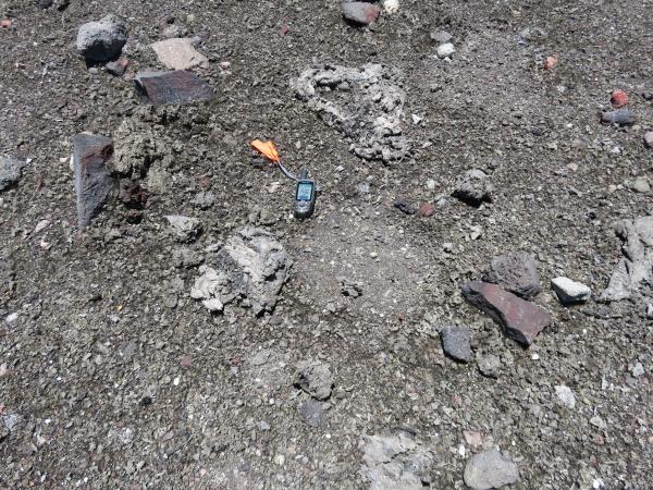
In areas not completely blanketed by tephra from the explosive event, impact marks were obvious where large fragments of molten lava (spatter) had landed on the rim of Halemaʻumaʻu Crater, then bounced or slid to their current positions. In this photo, two large pieces of spatter, 45-60 cm (18-24 in) across, can be seen to the upper right and lower left of the GPS unit. The slightly smoother circular features to the right of these fragments show where those bombs initially hit the crater rim. USGS/HVO photo.
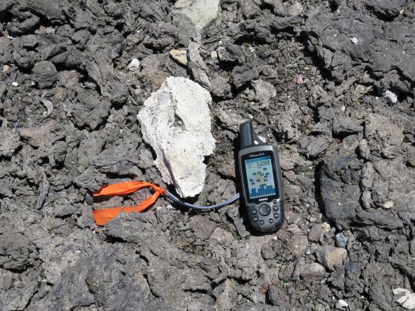
Tephra blasted from the summit vent on Saturday night included lithic (solid rock) fragments from the vent wall as well as spatter (molten lava fragments) ejected from the lava lake. The light-colored lithic in the center of this photo is about 8 inches long—the GPS unit is shown for scale. Tephra, the general term for volcanic rock fragments exploded or carried into the air during an eruption, can range from dust-size particles to fragments more than 3.2 feet in diameter. USGS/HVO photo.

An explosion triggered by a rockfall in Kīlauea Volcano’s summit lava lake on Aug. 6 blanketed the rim of Halemaʻumaʻu Crater with a layer of tephra (airborne volcanic rock fragments) up to about 8 inches thick. The tephra deposit is thickest to the east of the former visitor overlook (visible in distance), where it formed a continuous layer of dark-colored spatter (erupted as blobs of molten lava) and light-colored pieces of solid rock on the crater rim (visible in foreground). Had anyone been standing in this area when the explosion occurred, that person would have been severely injured or killed by the falling debris. USGS photo.
Sponsored Content


