At 5 p.m. HST, the center of Tropical Depression Flossie was located near latitude 18.9°N, longitude 149.8°W, approximately 350 miles east of Hilo. The depression is moving toward the west near 13 mph. This general motion is expected to continue into early Monday, with a turn toward the west-northwest forecast late Monday and Tuesday. On the forecast track, the weakening system will move near or over the main Hawaiian Islands Monday and Tuesday.
Maximum sustained winds are near 35 mph, with higher gusts. Weakening is forecast during the next 48 hours, and the system is expected to weaken to a post-tropical remnant low Monday night.
The estimated minimum central pressure is 29.80 inches.
The National Weather Service (NSW) in Honolulu has issued a Flash Flood Watch for the Big Island through Monday night. A Flash Flood Watch means that conditions are favorable for flash flooding. Flash flooding is life threatening. Do not cross fast flowing water in your vehicle or on foot.
NSW has also issued a High Surf Warning for north-, south- and east-facing shores of Hawai‘i Island through Monday. A High Surf Warning means large breaking surf, significant shore break, and dangerous currents that could cause significant injury or death.
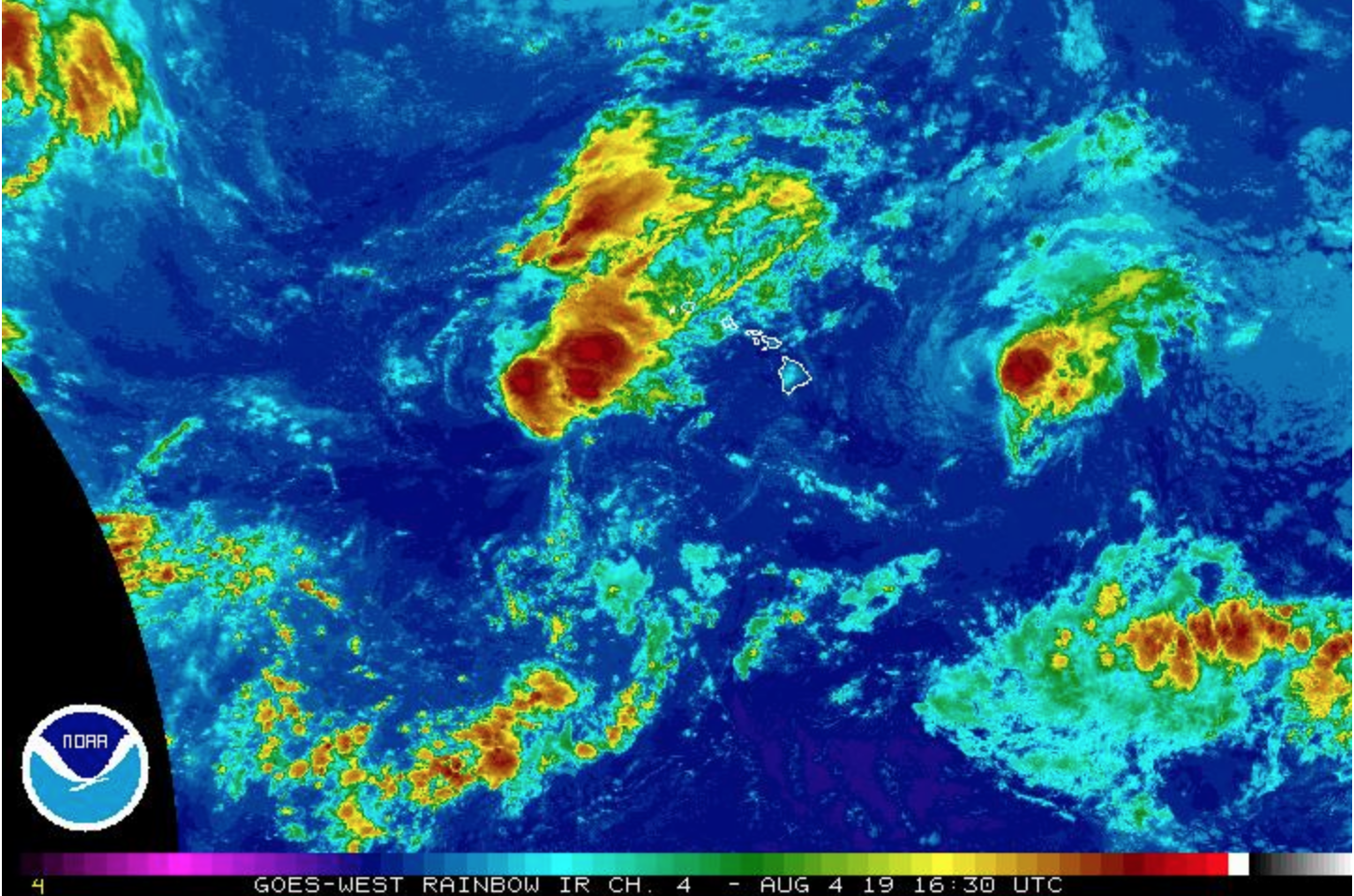
The Central Pacific Hurricane Center is issuing advisories on Tropical Storm Flossie, centered about 375 miles east of Hilo.
6 AM: High Surf Warning in Effect
As of 5 a.m. today, the center of Flossie was approximately 475 miles east of Hawai‘i Island at latitude 19.3°N and 147.8°W, moving in a W direction at a speed of 13 miles per hour.
ARTICLE CONTINUES BELOW AD
Be aware that tropical storms are erratic and can change speed, direction and intensity quickly.
The Central Pacific Hurricane Center has issued a High Surf Warning for east-facing shores of Hawai‘i Island through Monday. A High Surf Warning means large breaking surf, significant shore break, and dangerous currents that could cause significant injury or death.
The following public safety measures are in effect;
Beaches are open this morning, but may close at any time due to dangerous surf conditions which may reach 15 feet along east facing shores.
Whittington and Punaluu Beach Parks are open but camping permits and pavilion rentals are cancelled through the weekend.
Bayfront Parking lot on Kamehameha Avenue will remain closed until further notice.
The Hele-On Buses will continue to pick-up passengers behind the Afook-Chinen Civil Auditorium.
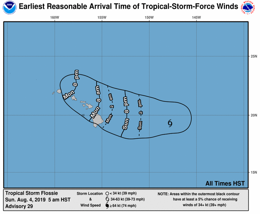
5 AM: FLOSSIE WEAKENING AS IT EDGES CLOSER TO HAWAI‘I
Flossie, 5 AM, Aug. 4, 2019. PC: NOAA
Flossie, 5 AM, Aug. 4, 2019. PC: NOAA
Flossie, 5 AM, Aug. 4, 2019. PC: NOAA
Flossie, 5 AM, Aug. 4, 2019. PC: NOAA
Flossie, 5 AM, Aug. 4, 2019. PC: NOAA
Flossie, 5 AM, Aug. 4, 2019. PC: NOAA
The center of Tropical Storm Flossie was located near latitude 19.3°N, longitude 147.8°W, about 475 miles E of Hilo, according to the NWS Central Pacific Hurricane Center in Honolulu.
Flossie is moving toward the west near 14 mph. This general motion is expected to continue over the next day or so, with a turn toward the NW expected on Tuesday. On the forecast track, Flossie will
move very close to the main Hawaiian Islands Monday and Tuesday.
Maximum sustained winds are near 40 mph with higher gusts.
Gradual weakening is forecast during the next 48 hours and Flossie is expected to weaken to a tropical depression on Monday.
Tropical-storm-force winds extend outward up to 90 miles from the center.
The estimated minimum central pressure is 29.74 inches.
HAZARDS AFFECTING LAND
SURF: Swells generated by Flossie will affect portions of the main Hawaiian Islands over the next couple of days, producing dangerous surf conditions, mainly along east- and SE-facing shores.
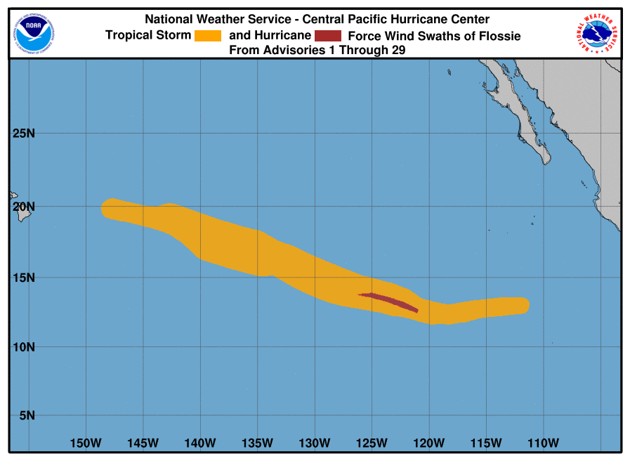
5 AM: GIL EXPECTED TO WEAKEN TO A REMNANT LOW LATER TODAY
TD Gil, 5 AM, Aug. 4, 2019. PC: NOAA
The center of Tropical Depression Gil is located near latitude 14.9°N, longitude 125.3°W. The
depression is moving toward the west near 10 mph and this general motion is expected to continue into Tuesday.
Maximum sustained winds have decreased to near 30 mph, with higher gusts. Additional weakening is forecast during the next day or so, and Gil is expected to become a remnant low later today and
dissipate by Monday night.
The estimated minimum central pressure is 29.80 inches.
This comments section is a public community forum for the purpose of free expression. Although Big Island Now encourages respectful communication only, some content may be considered offensive. Please view at your own discretion. View Comments


 BIG ISLAND CLOSURE, CANCELLATION, NOTICE UPDATES