East Rift Zone of Kīlauea Volcano will be surveyed by low-flying helicopter. PC: USGS
In early June 2019, it was announced that a lidar (Light Detection and Ranging) survey would be conducted on Kīlauea Volcano between June 13 and June 30. Due to technical issues and logistical challenges during that time, the survey has been extended into July.
What: A low-flying helicopter under contract to the U.S. Geological Survey will conduct a lidar (Light Detection and Ranging) survey to document changes that occurred during the 2018 Kīlauea volcanic activity.
Where: Kīlauea Volcano, primarily the summit and East Rift Zone areas
When: Survey will take 6 to 10 days, starting on July 13 and scheduled over the coming weeks, weather permitting.
Why: Lidar is the best way to detect and map vertical or near-vertical features, such as fissures, ground cracks, and caldera walls. Data acquired during this survey can be used to model likely paths that lava flows may take during future eruptions, which can help mitigate future lava flow hazards.
Residents near the summit and along the East Rift Zone of Kīlauea Volcano may see and hear a low-flying, bright yellow helicopter flying back and forth in a northeast-southwest direction over pre-planned flight lines. A helicopter is necessary to conduct a high-resolution lidar survey and to collect digital multispectral images to document changes that occurred during the 2018 Kilauea volcanic activity.
During the survey, the USGS asks residents for their patience and understanding regarding the helicopter noise as it completes this important survey.
ARTICLE CONTINUES BELOW AD
ARTICLE CONTINUES BELOW AD
Most flights will be at an altitude of about 1,300 feet above ground level. However, in a few East Rift Zone areas (Leilani Estates, Alaʻili Road, Puʻu ʻŌʻō), at the summit caldera, and on the upper Southwest Rift Zone, flights will be at an altitude of 500 feet above ground level.
Data acquired during this survey will enable USGS scientists to model where new lava flows may travel if renewed volcanic activity occurs in the lower East Rift Zone. From an emergency management perspective, having accurate elevation models was crucial during the past two Kīlauea eruption responses (2014-2015 and 2018). The precision of this new lidar survey will also improve the accuracy of earlier data sets which support ongoing scientific studies of past eruptions.
Data collected during this survey will be used by USGS scientists to produce a digital elevation model from which the volumes of erupted lava and summit subsidence in 2018 can be calculated. Products from the survey should be publicly available by late 2019.
ARTICLE CONTINUES BELOW AD
Windward Aviation, a Maui-based helicopter company, will conduct the survey under contract to Quantum Spatial. Experienced pilots, who are specially trained for low-level flying required for geophysical surveys, will operate the helicopter. The company works with the Federal Aviation Administration to ensure flights are in accordance with U.S. law.
This survey is a follow-up to the USGS lidar survey of the Puna area in July 2018 by the same contractor. More information about the lidar survey was posted in HVO’s May 30 “Volcano Watch” article (https://volcanoes.usgs.gov/observatories/hvo/hvo_volcano_watch.html?vwid=1414).
Map/Photo Captions:
ARTICLE CONTINUES BELOW AD
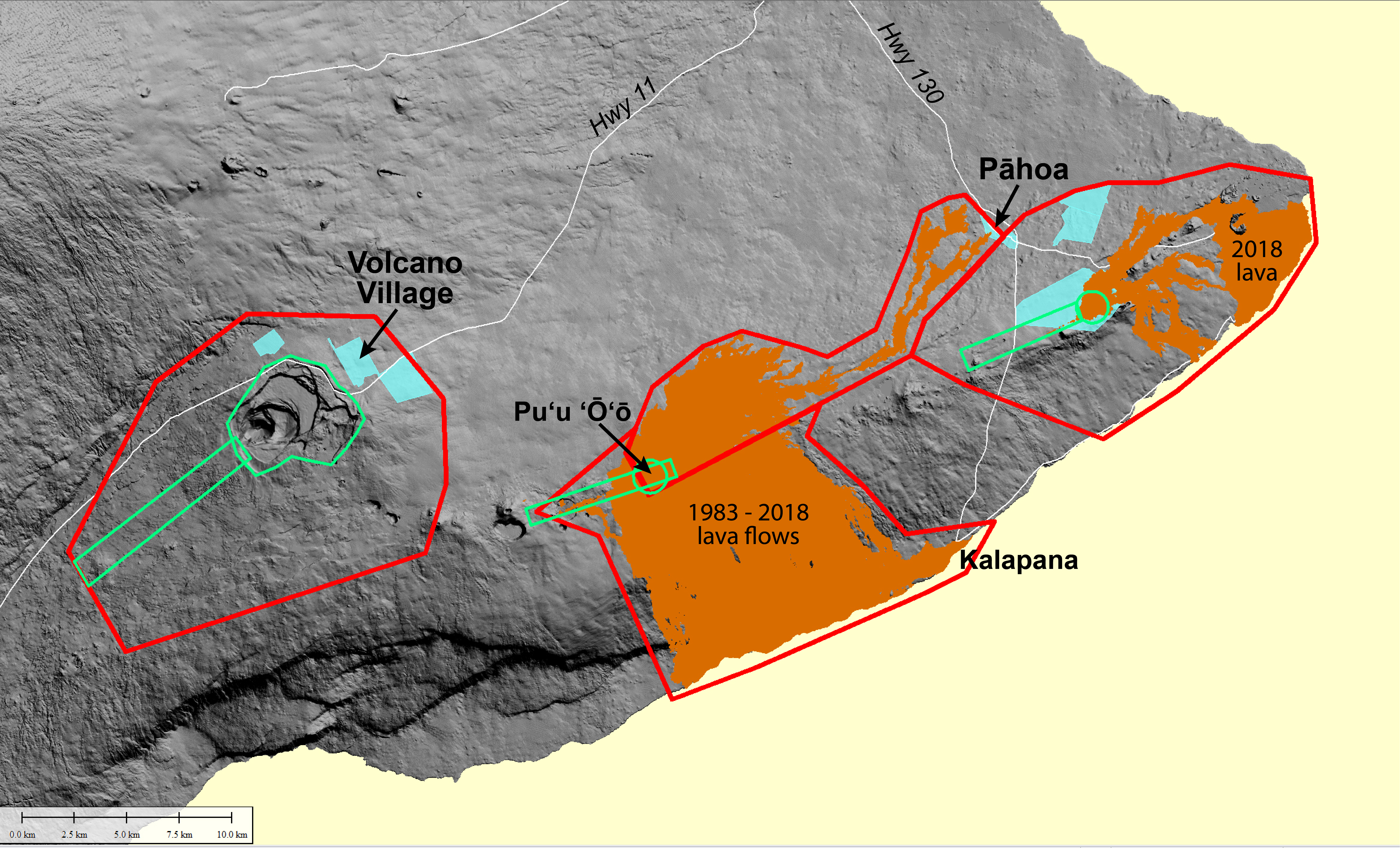
(1) Areas that will be covered by a helicopter lidar survey in July 2019. Red lines enclose areas over which the survey helicopter will fly at 396 m (1,300 ft) above ground level. Green lines enclose areas over which the helicopter will fly at 151 m (500 ft) above ground level. USGS map.
(2) During the lidar survey, equipment will be mounted on a bright yellow Hughes 500 helicopter like the one shown here. The helicopter will fly in a northeast or southwest direction over the survey areas depicted on the map. Photo courtesy of Windward Aviation.
This comments section is a public community forum for the purpose of free expression. Although Big Island Now encourages respectful communication only, some content may be considered offensive. Please view at your own discretion. View Comments