UPDATE: 4: 3:34 PM, Monday,July 8, 2019: National Weather Service Honolulu
The Flash Flood Watch has been cancelled but the Wind Advisory remains in effect until 8 p.m. The Gale Watch Warning also remains in effect until 6 p.m. Tuesday. The High Surf Warning is also in effect through Tuesday morning. The combination of strong trade winds and large east swell generated by former Tropical Cyclone Barbara will cause dangerous surf along the east-facing shores of the Big Island through tonight. Surf is expected to drop to advisory levels on Tuesday for the Big Island.
WINDS: East 25 to 35 mph with higher gusts for most of the Big Island and windward Moloka‘i.
TIMING: Strong gusty winds will continue until later this evening due to passage of a remnant trough associated with Barbara.
IMPACTS: Travel will become difficult on roads especially for high-profile vehicles.
PRECAUTIONARY/PREPAREDNESS ACTIONS
ARTICLE CONTINUES BELOW AD
ARTICLE CONTINUES BELOW AD
A Wind Advisory means that sustained winds of at least 30 mph, or gusts of at least 50 mph, are expected. Motorists should use extra caution.
UPDATE 3: 1:16 PM, Monday, July 8, 2019: Pacific Disaster Center
MULTIPLE POWER OUTAGES DUE TO TREES ON POWER
LINES IN THE PEPE‘EKEO, HONOKA‘A AND WAIMEA AREAS. REPORT VIA HAWAII ELECTRIC LIGHT AND
HAWAI‘I COUNTY DEPARTMENT OF PUBLIC WORKS SOCIAL MEDIA ACCOUNTS.
UPDATE 2: 1128 AM HST, Monday, July 8, 2019: National Weather Service Honolulu
The National Weather Service in Honolulu has issued a High Surf
Warning, which is in effect until 6 a.m. HST Tuesday. The High Surf Advisory is no longer in effect.
ARTICLE CONTINUES BELOW AD
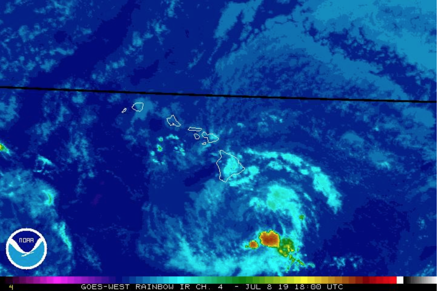
The combination of strong trade winds and large east swell generated by former Tropical Cyclone Barbara will cause dangerous surf along the east-facing shores of the Big Island through tonight. Surf is expected to drop to advisory levels on Tuesday for the Big Island. Elsewhere, advisory level surf will likely continue through Tuesday.
SURF: Along east-facing shores of the Big Island, 12 to 20 feet today lowering to 10 to 16 feet tonight.
TIMING: Surf peaking today and lowering tonight.
IMPACTS, High: Expect ocean water occasionally sweeping across portions of beaches, very strong breaking waves, and strong longshore and rip currents. Breaking waves may occasionally impact harbors making navigating the harbor channel dangerous.
PRECAUTIONARY/PREPAREDNESS ACTIONS
ARTICLE CONTINUES BELOW AD
Large breaking surf, significant shorebreak, and dangerous currents make entering the water very hazardous. Anyone entering the water could face significant injury or death. Boaters should be aware of an increased number of surfers and body boarders utilizing the harbor channel to access surfing areas.
UPDATE 1: 9:15 AM HST, Monday, July 8, 2019: National Weather Service Honolulu
FLASH FLOOD WATCH FOR THE BIG ISLAND THROUGH LATE TONIGHT
Areas affected are Kona, Kohala, south, north and east, and interior and summits of the Big Island.
Moisture associated with the remnant of Barbara will move over the Big Island today and tonight before diminishing. The threat for flash flooding from heavy rainfall will start along the windward slopes of the Big Island early this morning, and spread to leeward areas around noon HST.
PRECAUTIONARY/PREPAREDNESS ACTIONS
A Flash Flood Watch means that conditions are favorable for flash flooding. Flash flooding is LIFE-THREATENING. Do not cross fast flowing water in your vehicle or on foot.
Monitor later forecasts and be prepared to take action if a Flash Flood Warning is issued. If you experience heavy rain or rising water, head to higher ground immediately.
ORIGINAL: 3:46 AM HST, Monday, July 8, 2019: National Weather Service Honolulu HI
Deep tropical moisture associated with the remnants of Barbara will pass over the Big Island of Hawaiʻi today and tonight before diminishing.
The threat of flash flooding from heavy rain will start along the windward slopes of the Big Island early this morning and spread to leeward areas around noon.
Because of the flooding threat, a Flash Flood Watch is in effect for the Big Island through late tonight.
The National Weather Service in Honolulu has issued a High Surf Advisory, which is in effect until 6 AM HST Tuesday for south, north and east Big Island shores.
The National Weather Service in Honolulu has also issued a Wind Advisory, which is in effect until 8 p.m. HST this evening.
A Gale Warning is in effect for the Alenuihaha Channel and waters south and has extended the Small Craft Advisory to 6 a.m. Tuesday for windward waters of the Big Island.
The low-level remnant will result in an increase in clouds, showers and wind speeds across the state.
Drier weather is expected to return from Tuesday into Wednesday.
This comments section is a public community forum for the purpose of free expression. Although Big Island Now encourages respectful communication only, some content may be considered offensive. Please view at your own discretion. View Comments


 UPDATE: 4: 3:34 PM, Monday,July 8, 2019:


