11 AM HST, Fri day, June 28, 2019: NWS National Hurricane Center Miami FL
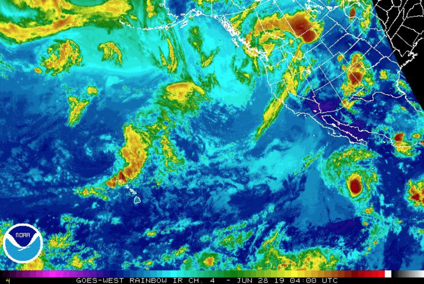
Alvin is rapidly weakening due to motion over sea surface temperatures of 23 to 24°C and increasing southwesterly vertical wind shear, with the low-level center now partly exposed at the southern edge of the weakening convective mass.
DISCUSSION AND OUTLOOK
At 11 a.m., the center of Tropical Storm Alvin was located near latitude 19.7° north, longitude 118.6° West. Alvin is moving toward the NW near 15 mph. A gradual turn toward the WNW and a decrease in forward speed are expected during the next couple of days.
Maximum sustained winds have decreased to near 50 mph with higher gusts. Continued rapid weakening is forecast and Alvin is expected to decay to a remnant low by late Saturday or Saturday night and then dissipate by Sunday.
Tropical-storm-force winds extend outward up to 60 miles from the center.
ARTICLE CONTINUES BELOW AD
ARTICLE CONTINUES BELOW AD
The estimated minimum central pressure is 29.53 inches.
SUMMARY
LOCATION: 19.7°N 118.6°W
ABOUT 600 MILES WSW OF THE SOUTHERN TIP OF BAJA CALIFORNIA
MAXIMUM SUSTAINED WINDS: 50 MPH
PRESENT MOVEMENT: NW OR 310 DEGREES AT 15 MPH
MINIMUM CENTRAL PRESSURE: 29.53 INCHES
WATCHES AND WARNINGS
There are no coastal watches or warnings in effect.
HAZARDS AFFECTING LAND
None.
ARTICLE CONTINUES BELOW AD
2 AM HST, Friday, June 28, 2019: NWS Central Pacific Hurricane Center Honolulu HI
For the central North Pacific between 140°W and 180°W, no tropical cyclones are expected during the next five days.
11 PM, Thursday, Jun 27, 2019: NWS National Hurricane Center Miami FL
ALVIN BEGINNING TO WEAKEN
Alvin continues to lose organization as a steady weakening trend has commenced. By Saturday night, Alvin is expected to become devoid of deep convection and the cyclone is forecast to dissipate by Sunday.
ARTICLE CONTINUES BELOW AD
Alvin accelerated slightly overnight, with an initial motion of 14 knots. This faster motion is expected to be only temporary. Alvin will be steered around the SW periphery of mid-level ridging to its north through today.
Thereafter, a much weaker cyclone will become steered by the lower level environmental
flow, which will result in a turn to the WNW and decrease in forward speed tonight into Saturday.
DISCUSSION AND OUTLOOK
At 11 p.m., the center of Tropical Storm Alvin was located near latitude 18°N, longitude 116.3°W.
Alvin is moving toward the NW near 15 mph and a gradual turn toward the WNW with a decrease in forward speed is expected over the next couple of days.
Maximum sustained winds are near 70 mph (110 km/h) with higher gusts. Weakening is expected over the next day or two, and Alvin is forecast to become a remnant low on Saturday and should dissipate
soon thereafter.
Tropical-storm-force winds extend outward up to 45 miles from the center.
The estimated minimum central pressure is 29.36 inches.
SUMMARY
LOCATION…18.0N 116.3W
ABOUT 535 MI…860 KM SW OF THE SOUTHERN TIP OF BAJA CALIFORNIA
MAXIMUM SUSTAINED WINDS…70 MPH…110 KM/H
PRESENT MOVEMENT…NW OR 305 DEGREES AT 15 MPH…24 KM/H
MINIMUM CENTRAL PRESSURE…994 MB…29.36 INCHES
WATCHES AND WARNINGS
There are no coastal watches or warnings in effect.
This comments section is a public community forum for the purpose of free expression. Although Big Island Now encourages respectful communication only, some content may be considered offensive. Please view at your own discretion. View Comments


 11 AM HST, Fri day, June 28, 2019: NWS National Hurricane Center Miami FL


