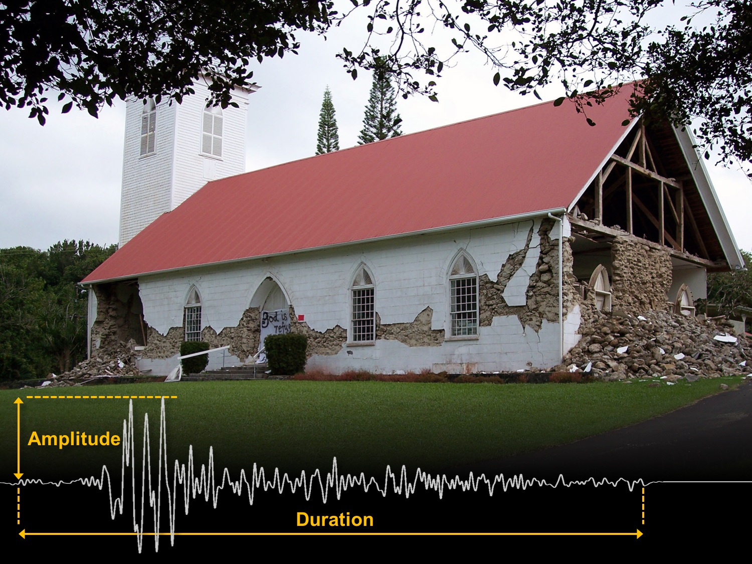
The Kalāhikiola Congregational Church in Kapa‘au was extensively damaged on October 15, 2006, by two earthquakes (magnitudes 6.7 and 6.0) off the northwest coast of Hawaiʻi Island. The earthquakes were felt throughout the State of Hawaii, but the greatest damage occurred in the North Kona and Kohala Districts of the Island of Hawaiʻi. An example of a seismogram (bottom of photo) illustrates the relation between the amplitude and duration of shaking, which is used by seismologists to compute earthquake magnitudes. USGS photo.
Characterizing earthquakes is one of the most important activities we do at the USGS Hawaiian Volcano Observatory. Seismicity helps us monitor the “pulse” of volcanoes and can be the first indication of an impending eruption.
Earthquakes also pose a hazard in their own right; the entire State of Hawai‘i is at risk from damaging earthquakes. They occur abruptly, so we must be vigilant and prepared.
HVO posts preliminary information about earthquake location and size (magnitude) as soon as possible after an earthquake occurs. Later, we update the information as more data becomes available. Sometimes the reported magnitude changes during this process.
When the earth shakes, vibrating seismic waves radiate outward from the source. These waves are picked up by sensitive instruments called “seismometers,” which are located across the state. Seismic data is relayed in near real-time to HVO, where computers that detect earthquake patterns keep watch around the clock. When four or more stations detect an earthquake, the computer automatically estimates the location and magnitude of the event.
If the earthquake magnitude is above 3.0, the computer posts the information on HVO’s website without human intervention. The USGS Earthquake Notification Service then alerts subscribers. This generally happens within five minutes of the earthquake.
ARTICLE CONTINUES BELOW AD
ARTICLE CONTINUES BELOW AD
HVO’s seismologists then spring to action to review the data. They recalculate the earthquake parameters and, if needed, overwrite the previously posted automatic ones. For magnitude-4.0 and higher earthquakes, we complete our manual review within two hours and issue a news release. Events smaller than magnitude-4.0 are reviewed routinely within a few days.
Upon review by a seismologist, the earthquake’s magnitude can go up or down by a few tenths. Different groups, such as the Pacific Tsunami Warning Center and the USGS National Earthquake Information Center, might also report slightly different magnitudes. To understand these differences, let’s review what magnitude means.
The concept of earthquake magnitude dates back to 1935, when Charles Richter created a way to compare the relative sizes of earthquakes in southern California. He measured how the amplitude of shaking recorded by seismometers decreased with distance from an earthquake. Using the logarithm of the maximum amplitude, Richter was able to derive a scale that conveyed the wide range of earthquake sizes, which can vary by several orders of magnitude (hence the name). For example, on this scale, the amplitude of a magnitude-4.0 earthquake is ten times higher than that of a magnitude-3.0 earthquake.
Today, there are numerous types of earthquake magnitudes that take advantage of advances in seismic instrumentation and cover a wide range of situations. For earthquakes higher than about magnitude 5.5, the most common measure of magnitude is called “moment magnitude,” which relates fundamentally to the energy released by an earthquake’s fault motion. For every .2 increase in moment magnitude, the energy doubles. For example, a magnitude-6.2 earthquake releases roughly twice as much energy as a magnitude-6.0 event.
For smaller earthquakes, like those that happen daily in Hawai‘i, HVO computes two types of magnitude based on either the duration or amplitude of the shaking recoded by seismometers. Duration magnitude tends to work better for smaller earthquakes (less than about magnitude 2.0) that are located shallower than 12 miles beneath the surface. Amplitude magnitude, which is a modern-day formulation of Richter’s magnitude, works better for local earthquakes with magnitudes between about 2.0 and 5.5.
ARTICLE CONTINUES BELOW AD
Any reported magnitude is actually an average of values computed for each seismometer that recorded the earthquake. These values vary depending on distance, direction, instrument, and the type of material type along the seismic wave’s path. HVO seismologists evaluate which stations provide the most reliable and objective magnitude estimates, average them together, and select either duration or amplitude as the preferred magnitude type for each event.
Magnitudes can change following a seismologist’s review and analysis of the computer’s automatic magnitude assignment. This process provides the best information available at any given time and offers a window into how the science of real-time seismology unfolds.
What matters more than a number, however, is what you do if you feel shaking during an earthquake. On Oct. 20, we encourage you to take part in the world’s largest earthquake preparedness exercise by practicing “Drop, Cover and Hold On!” during the Great Hawai‘i ShakeOut.
Volcano Activity Updates
Kīlauea continues to erupt at its summit and East Rift Zone. This past week, the summit lava lake level dropped in concert with summit deflation, from about 33 feet to as low as 154 feet below the vent rim within Halema‘uma‘u Crater.
ARTICLE CONTINUES BELOW AD
The 61g lava flow continued to enter the ocean near Kamokuna. The lava flow does not pose an immediate threat to nearby communities.
Mauna Loa is not erupting. Seismicity remains elevated relative to the long-term background rate, with small earthquakes occurring mostly in the volcano’s south caldera and upper Southwest Rift Zone at depths less than 3 miles. Global Positioning System (GPS) measurements show deformation related to inflation of a magma reservoir beneath the summit and upper Southwest Rift Zone.
No earthquakes were reported felt on the Island of Hawaiʻi this past week.
Volcano Watch is a weekly article and activity update written by U.S. Geological Survey Hawaiian Volcano Observatory scientists and affiliates.
Call for summary updates at (808) 967-8862 (Kīlauea) or (808) 967-8866 (Mauna Loa); email questions to [email protected].
This comments section is a public community forum for the purpose of free expression. Although Big Island Now encourages respectful communication only, some content may be considered offensive. Please view at your own discretion. View Comments