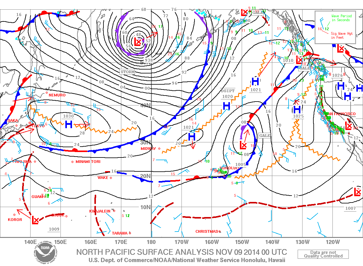
A HIGH SURF ADVISORY has been issued by the National Weather Service for the northeast facing shores of the Big Island until 6:00 pm tonight.
Expect strong breaking waves, shore break and strong currents making swimming difficult and dangerous. Anyone entering the water could face significant injury due to the dangerous hazards this swell will pose. Boaters are asked to be aware of the increased number of surfers likely to be in the water.
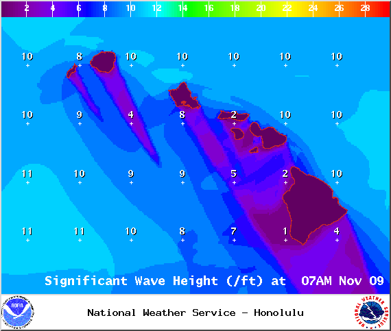
A SMALL CRAFT ADVISORY will be posted for the Alenuihaha channel and both Big Island windward and leeward waters through 6:00 pm tonight. North to northeast winds of 25 knots are expected with rough seas up to 11 feet. Inexperienced mariners should avoid navigating in these conditions.
**A breakdown of expected conditions specific to the Big Island is presented below. Click directly on the image to make it larger.**
+
SWIPE LEFT OR RIGHT
Today
ARTICLE CONTINUES BELOW AD
ARTICLE CONTINUES BELOW AD
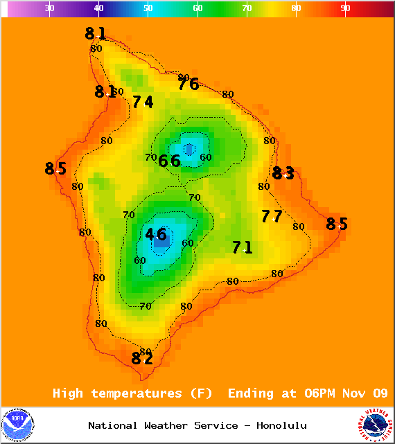
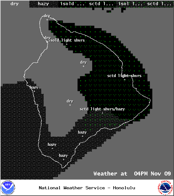
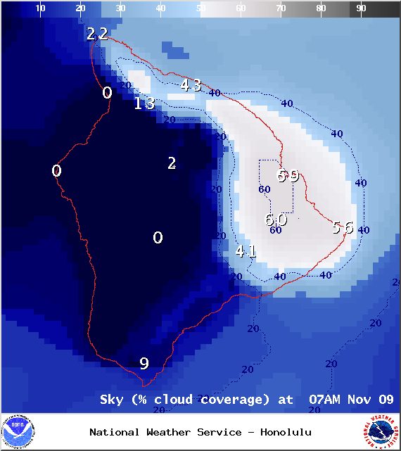
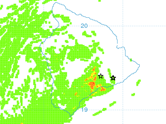
We expect mostly sunny skies today with just isolated showers across Hawaii County. The Kona side is forecasted to be mostly clear. High temperatures should fall in the range of 81° to 86° and around 72° at 5000 feet. In general, northeast winds from 10 to 15 mph are expected.
Sunrise: 6:25 a.m.
Sunset: 5:43 p.m.
UV index at 7 (“high” exposure level)
ARTICLE CONTINUES BELOW AD
Tonight
We expect partly cloudy skies tonight with isolated showers for windward and mauka areas. Leeward spots should be mostly clear. Variable winds are expected up to 15 mph. Low temperatures should fall in the range of 68° to 74° with a low of about 56° at 5000 feet.
Moonrise: 8:31 p.m.
Moonset: 9:52 a.m.
Next New Moon: Nov 22 at 2:33 a.m.
ARTICLE CONTINUES BELOW AD
Next Full Moon: Dec 6 at 2:27 a.m.
Looking Ahead
The front that has been affecting the state this weekend is weakening and gradually losing steam near the Big Island today. The northerly winds that followed the front are expected to become lighter and more easterly into the work week. Dry conditions are expected in the wake of the front, persisting through at least Veteran’s Day with another front expected to impact the eastern part of the state the second half of the work week. The highest chance for showers with this front is for the Big Island.
Surf & Seas
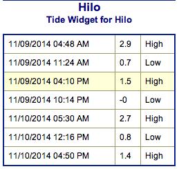
Hilo side: Surf is expected in the waist to chest high range for spots best exposed to the trade swell. The north-northwest is expected to bring overhead to double overhead or bigger waves to the best breaks exposed to the swell.
Kona side: Surf is expected to be thigh high or less. Breaks not exposed to the swell will be flat today. Spots that catch some of the north-northwest wrap could see waves up to waist or chest high at the best breaks.
South: Best breaks could see waves up to waist or maybe even shoulder high for spots exposed to the trade swell along the southeast coast. South breaks that are not exposed to the trade swell should see waves thigh high or less.
Our current north-northwest swell (320-345°) is peaking into this morning with waves double to triple overhead at the best breaks early in the day. The swell will gradually fade but still offer overhead to possibly double overhead wave heights through tomorrow morning, easing to head high by sundown.
Former super typhoon Nuri is making history. After becoming extratropical and merging with a frontal system the storm is now the strongest non-tropical storm ever recorded in the North Pacific. The system is expected to bring us a solid northwest swell (310-335°) building through Veteran’s day, peaking in the afternoon and into Wednesday with overhead to double overhead waves, maybe even bigger sets at the best exposures despite being heavily shadowed. The Kona side will be significantly smaller but may still catch a wrap at the best breaks.
If the storms develop, we may get a series of solid northwest swells Thursday through the weekend too.
Small swells generated in the South Pacific are expected to bring us waves in the thigh high or less range. You might see possible plusses at the best tides and exposures but they will be inconsistent at best and most Kona spots will remain flat. There isn’t much on the horizon out of the South Pacific.
Keep in mind, surf heights are measured on the face of the wave from trough to crest. Heights vary from beach to beach, and at the same beach, from break to break.
Almanac for Hilo Airport
Maximum Temperature for today:
Normal 81°
Record 86° / Set in 1955 and tied in 1977
Minimum Temperature for today:
Normal 68°
Record 62° / Set in 1970 and tied in 1979
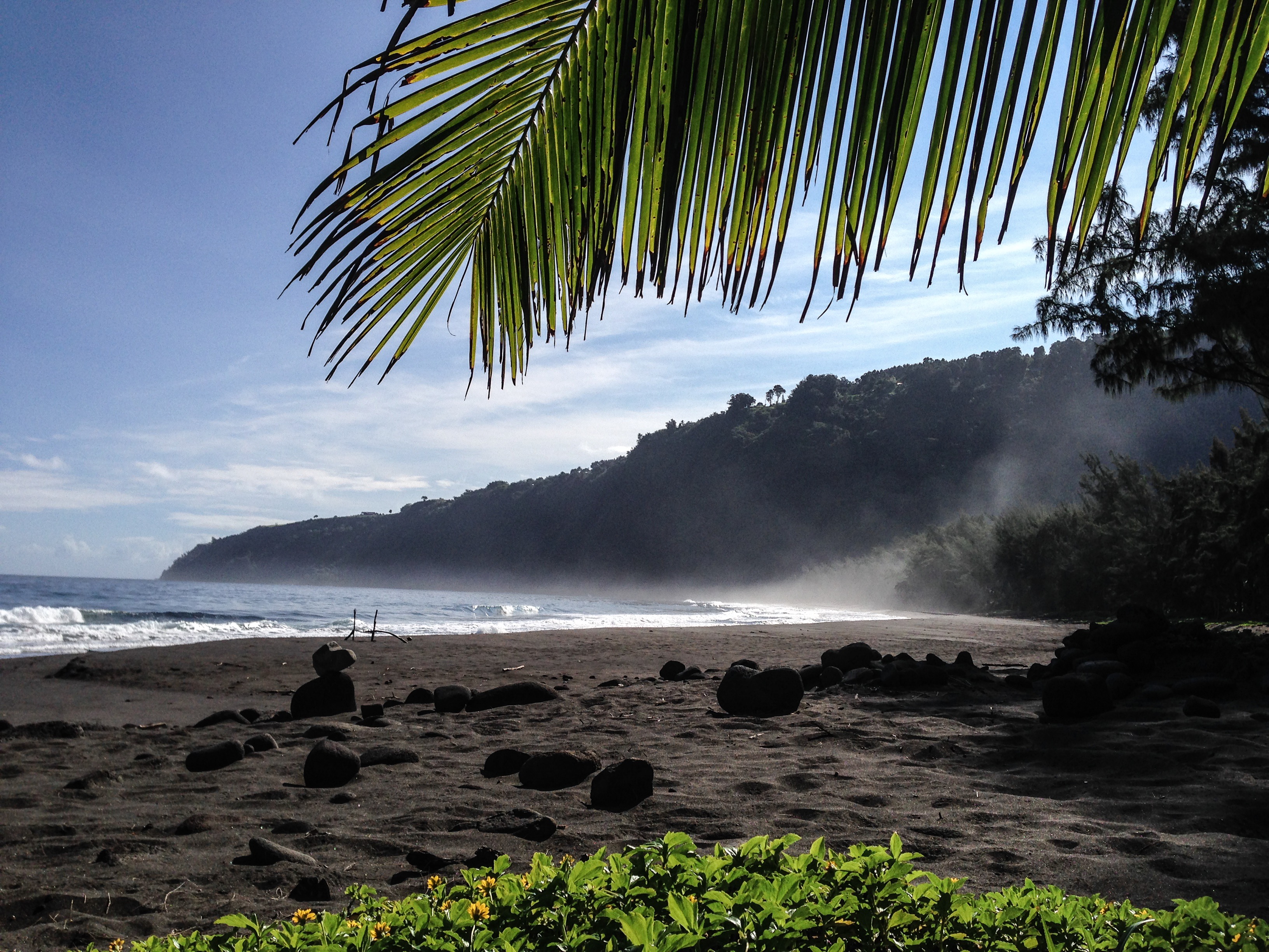
Waipio Valley / Image: James M Grenz
Image: NOAA / NWS
Image: NOAA / NWS
Expected weather conditions at 7am – Image: NOAA / NWS
Expected weather conditions at 4pm – Image: NOAA / NWS
Expected chance of cloud cover at 7am – Image: NOAA / NWS
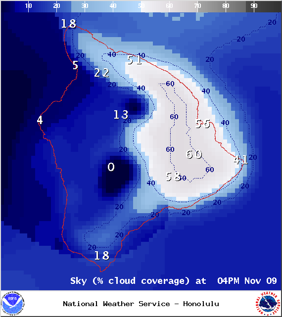
Expected chance of cloud cover at 4pm – Image: NOAA / NWS
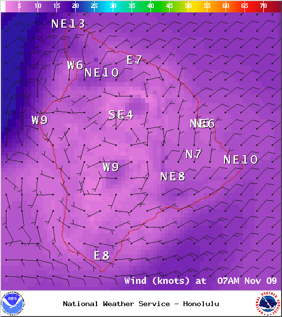
Expected wind conditions at 7am – Image: NOAA / NWS
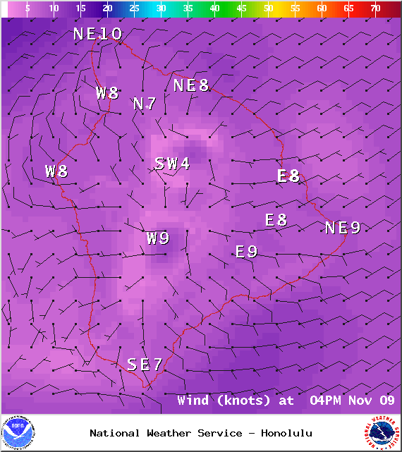
Expected wind conditions at 4pm – Image: NOAA / NWS
This comments section is a public community forum for the purpose of free expression. Although Big Island Now encourages respectful communication only, some content may be considered offensive. Please view at your own discretion. View Comments


 Surf & Seas
 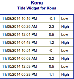 Our current north-northwest swell (320-345°) is peaking into this morning with waves double to triple overhead at the best breaks early in the day. The swell will gradually fade but still offer overhead to possibly double overhead wave heights through tomorrow morning, easing to head high by sundown.