Showers Easing, But More on Tap for Sunday
After a soggy few days, residents of the windward side of the Big Island should see a brief respite from rainy weather, the National Weather Service said today.
But according to forecaster Bob Ballard, they probably shouldn’t be making outdoor plans for Sunday.
The eastern side of the island has seen showery weather – including some full-fledged thunderstorms – since the passing of the remnants of tropical storm Fausto on Sunday.
That and another low-pressure system that passed through on Tuesday pushed three-day rainfall totals to more than a foot in at least one location.
Fortunately, the Saddle Quarry, which saw 12.61 inches of rain in the 72-hour period ending at 8 a.m. today, is not a populated area.
But residents of the upper Hilo area of Waiakea Uka weren’t far behind with 10.55 inches during that stretch, including 4.37 inches in the 12 hours between 8 p.m. Tuesday and this morning.
And neither Hamakua nor upper Puna were spared, with Hakalau receiving 7.60 inches and Mountain View 9.18 inches during the past three days.
Lower Puna got off relatively easy with 3.73 inches in Pahoa over the 72-hour period.

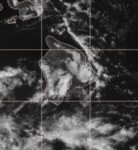
This satellite photo taken at 10:30 a.m. shows skies clearing — at least temporarily — over some parts of the Big Island. NOAA image.
Ballard said Tuesday’s system is moving on, which means the showers should diminish today and toward the weekend.
The exception could be the leeward slopes of Kona, where onshore breezes, combined with afternoon heating, could create showers and maybe even a bit of lightning.
But another wet spell is approaching.
“In the deep tropics it’s not unusual to get these waves of low pressure that are usually accompanied by showers,” he said.
Sometimes they pass south of the Big Island, but recently they’ve been hitting it squarely.
The next system is currently expected to reach the island by Saturday night, but it’s still too far away to be sure, Ballard said.


