

BLOG: A Baffling EIS, and Other Confusing Letters of the Alphabet
You can’t always trust what you read, and that includes those bastions of government planning: environmental assessments and environmental impact statements.
Case in point: the “Kona Judiciary Complex Site Selection Final Environmental Impact Statement,” which was completed in early 2012 by Honolulu-based consultant Group 70 International.
(Quick disclosure: This writer spent several years between journalism gigs assisting planning firms in the sometimes perplexing and often tedious preparation of EAs and EISs, although not for Group 70.)
I did an article Thursday about the state Judiciary’s decision to change the location for the new Kona courthouse from the site originally picked near the county’s West Hawaii Civic Center (Site “G”), to one near Makalapua Center near Queen Kaahumanu Highway (Site “F”).
In the process of writing the article I did the usual due diligence (or so I thought), including checking the final EIS for references to the sites and for a map for guidance.
The various potential sites – and there were many, including 14 in one part of the study, with at least one more later added for consideration – were featured in both Chapter 3, which identifies the candidate locations, and Chapter 4, which evaluates them.
And boy, don’t I wish now that I had skipped Chapter 3 altogether.
The problem: The letters identifying the sites differ between the two chapters.
The first site selected (“G”) but then rejected is shown in a completely different location in the EIS’ Chapter 3. And the new site picked (“F”), is shown in Chapter 3 as site “I.”
Both were shown in the “correct” location in Chapter 4.
So, after several email and telephone go-arounds about the alphabet soup with Judiciary spokeswoman Marsha Kitagawa late Thursday afternoon, it appeared that I had things figured out.
Until I modified a map from the EIS to indicate the locations of the previous and current sites.
Hence, I received another email from Marsha this morning saying that I had labeled the wrong location for the previous site (that “G” again).
Oh, I had picked “G” alright, but not the right one, because in my haste to post the article I had used as a reference a map from Chapter 3 – which, ironically, did not even show a site where the correct “G” was supposed to be.
It turns out that particular “G” was added later in the planning process, but why Chapter 3 was not updated to reflect that, or why site designations were changed in Chapter 4, remains a mystery.
The folks at Group 70 could not immediately be reached for comment.
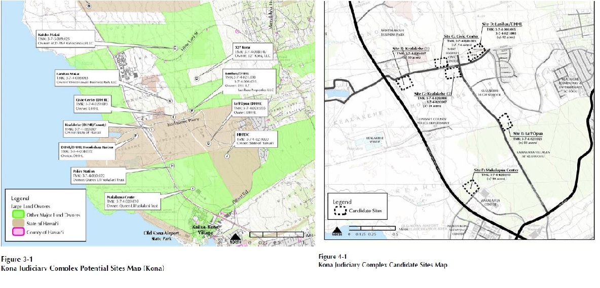
Shown above are maps from the Kona courthouse final EIS from Chapter 3, left, also known as the culprit, and one from Chapter 4. (Click image to enlarge.)


Sponsored Content

