UPDATE 1: 5 PM HST: Tuesday, June 25, 2019: Tropical Depression One-E Discussion Number 2, NWS National Hurricane Center Miami FL
DEPRESSION EXPECTED TO BECOME A TROPICAL STORM ON WEDNESDAY
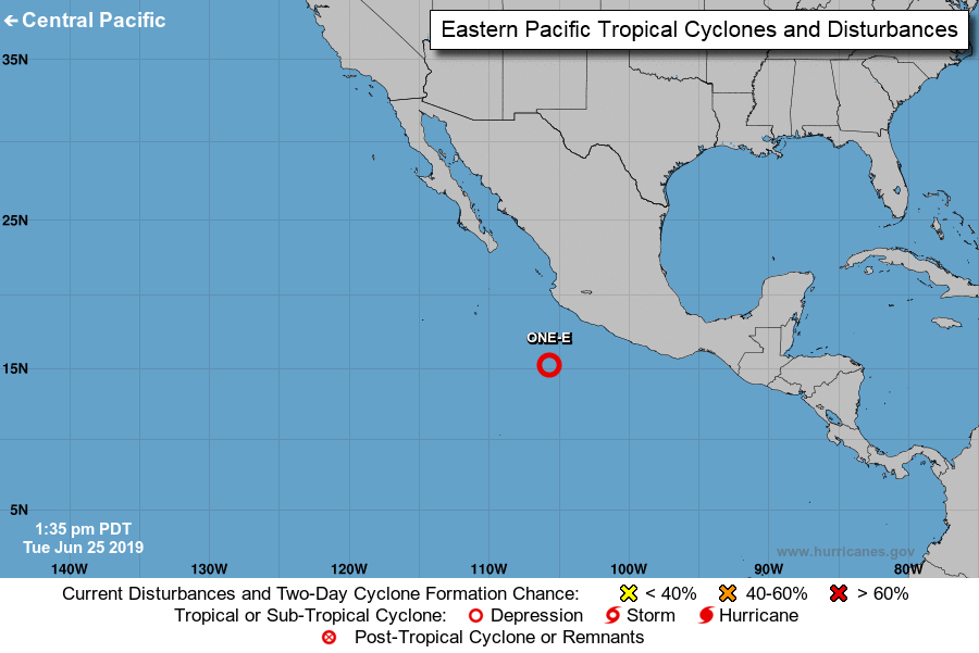
LOCATION…15.6N 106.8W
ABOUT 285 MI…460 KM SW OF MANZANILLO MEXICO
ABOUT 545 MI…875 KM SSE OF THE SOUTHERN TIP OF BAJA CALIFORNIA
MAXIMUM SUSTAINED WINDS…35 MPH…55 KM/H
PRESENT MOVEMENT…WNW OR 290 DEGREES AT 15 MPH…24 KM/H
MINIMUM CENTRAL PRESSURE…1006 MB…29.71 INCHES
WATCHES AND WARNINGS
There are no coastal watches or warnings in effect.
DISCUSSION AND OUTLOOK
At 5 p.m. HST, the center of Tropical Depression One-E was located near latitude 15.6 north, longitude 106.8 west. The depression is moving toward the west-northwest near 15 mph and a WNW to west motion with some decrease in forward speed is expected over the next few days.
Maximum sustained winds are near 35 mph with higher gusts. Some strengthening is forecast during the next day or so, and the depression is forecast to become a tropical storm on Wednesday. The system is forecast to begin weakening on Thursday.
ARTICLE CONTINUES BELOW AD
ARTICLE CONTINUES BELOW AD
The estimated minimum central pressure is 29.71 inches.
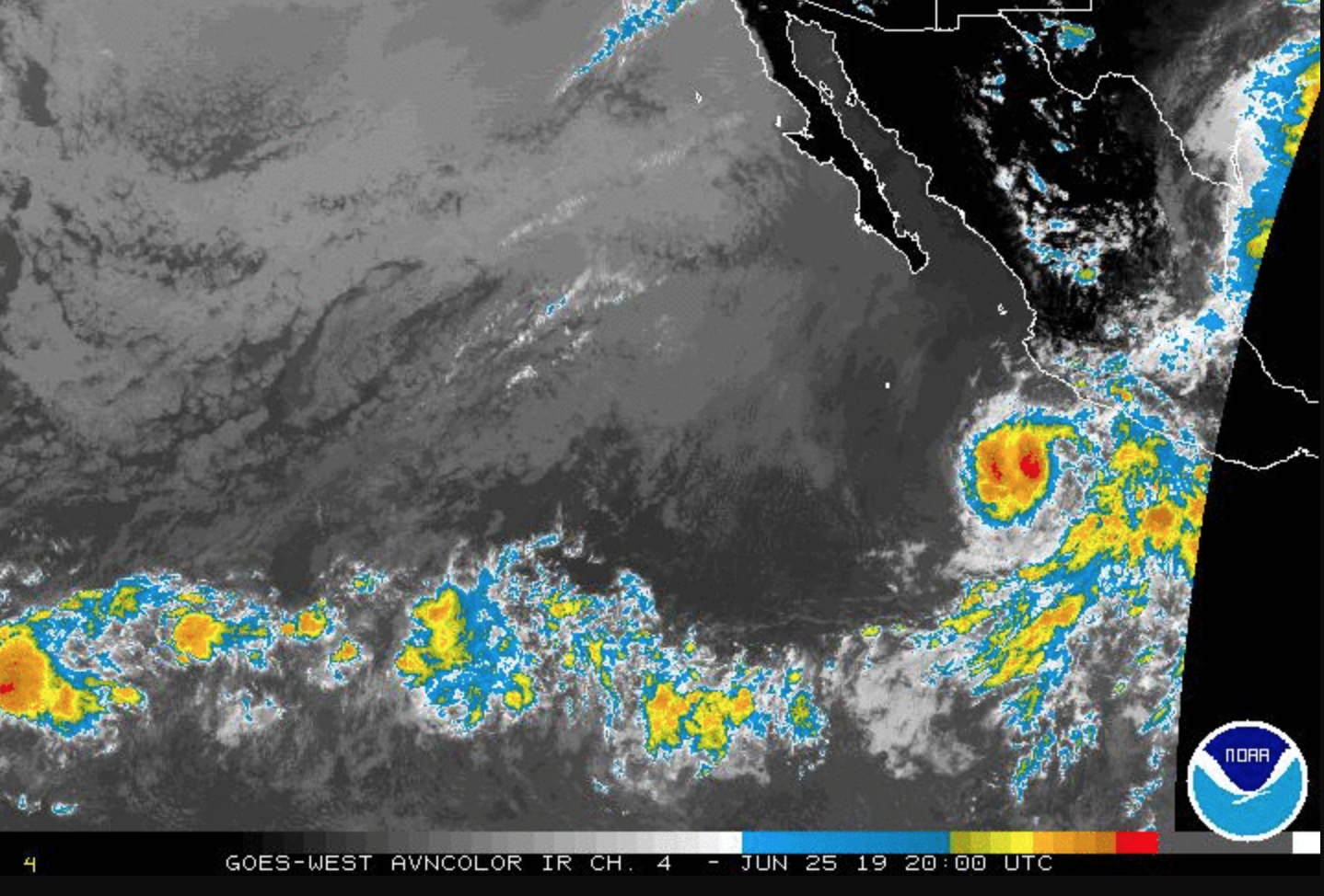
The cyclone has not yet acquired well-defined convective banding features and the deep convection is rather fragmented at this time; however microwave imagery shows a fairly well-defined inner circulation structure. The initial intensity is set at 30 knots in accord with Dvorak estimates from TAFB and SAB.
Hopefully, the National Hurricane Center will soon obtain a scatterometer overpass to provide a better estimate of the intensity of the system. The cyclone should move over sufficiently warm waters and within low vertical shear over the next day or so. Therefore some strengthening is forecast until around
the 36 hours time frame. Thereafter, increasing SSW shear, cooler waters and drier mid-level air should induce weakening. The official intensity forecast is similar to the previous one and very close to the latest model consensus prediction.
Based on microwave and geostationary satellite center fixes, a fairly brisk WNW motion, at about 290/13 knots continues. The primary steering mechanism for the next couple of days will be a mid-level ridge extending westward from NW Mexico into the Pacific. The tropical cyclone should gradually slow its forward speed as it nears the western periphery of the ridge. The official track forecast is close to the previous one, and is in agreement with the latest simple and corrected dynamical model consensus solutions. The ECMWF model shows a track at a more southern latitude, but that model’s prediction of the cyclone’s evolution seems to be unrealistically weak.
ORIGINAL: 11 AM HST, June 25, 2019: NWS National Hurricane Center Miami FL
FIRST TROPICAL DEPRESSION OF THE 2019 EASTERN PACIFIC HURRICANE SEASON FORMS
Tropical Depression One-E Discussion Number 1
Convection associated with the area of low pressure located south of the coast of Mexico has become sufficiently well organized today, and visible satellite imagery suggest that the system has acquired a well-defined center.
ARTICLE CONTINUES BELOW AD
Based on these observations, advisories are being initiated on the first tropical depression of the 2019
eastern Pacific hurricane season.
The latest Dvorak T-numbers from TAFB and SAB are 2.0 and 1.5 respectively, and the initial wind speed has been set at 25 knots.
The depression is forecast to remain over warm sea surface temperatures and within a low wind shear environment during the next couple of days. Although there is some dry mid-level air to the west of the cyclone, modest strengthening is indicated by most of the intensity guidance, and the NHC foreast follows suit.
After 48 hours, increasing south-southwesterly shear and cooler waters are expected to cause weakening, and the system is forecast to become a remnant low in three to four days.
The somewhat uncertain initial motion estimate is 290/13 knots. A mid-level ridge extending from northwestern Mexico into the eastern Pacific should steer the cyclone WNW during the next
few days.
There is spread in the guidance as to how much latitude the system will gain over the next few days.
The ECMWF which does not deepen the system much, if at all, shows a more southern track than the remainder of the guidance. The NHC forecast assumes that the system will strengthen some and shows a more climatological WNW track close to the multi-model consensus.
LOCATION…15.2N 105.7W
ABOUT 280 MI…450 KM SSW OF MANZANILLO MEXICO
ABOUT 600 MI…960 KM SSE OF THE SOUTHERN TIP OF BAJA CALIFORNIA
MAXIMUM SUSTAINED WINDS…30 MPH…45 KM/H
PRESENT MOVEMENT…WNW OR 290 DEGREES AT 15 MPH…24 KM/H
MINIMUM CENTRAL PRESSURE…1007 MB…29.74 INCHES
WATCHES AND WARNINGS
There are no coastal watches or warnings in effect.
DISCUSSION AND OUTLOOK
At 11 a.m., the center of Tropical Depression One-E was located near latitude 15.2 North, longitude 105.7 West. The depression is moving toward the WNW near 15 mph and a WNW to W motion with some decrease in forward speed is expected over the next few days.
Maximum sustained winds are near 30 mph with higher gusts.
Some strengthening is forecast during the next day or so, and the depression is forecast to become a tropical storm on Wednesday or Wednesday night. The system is forecast to begin weakening on Thursday.
The estimated minimum central pressure is 1007 mb (29.74 inches).
HAZARDS AFFECTING LAND
None
NEXT ADVISORY
Next complete advisory at 5 p.m. HST
11 AM HST, June 25, 2019: TROPICAL DEPRESSION ONE-E FORECAST/ADVISORY NUMBER 1
NWS NATIONAL HURRICANE CENTER MIAMI FL
THERE ARE NO COASTAL WATCHES OR WARNINGS IN EFFECT.
TROPICAL DEPRESSION CENTER LOCATED NEAR 15.2N 105.7W AT 25/2100Z
POSITION ACCURATE WITHIN 40 NM
PRESENT MOVEMENT TOWARD THE WEST-NORTHWEST OR 290 DEGREES AT 13 KT
ESTIMATED MINIMUM CENTRAL PRESSURE 1007 MB
MAX SUSTAINED WINDS 25 KT WITH GUSTS TO 35 KT.
WINDS AND SEAS VARY GREATLY IN EACH QUADRANT. RADII IN NAUTICAL
MILES ARE THE LARGEST RADII EXPECTED ANYWHERE IN THAT QUADRANT.
REPEAT…CENTER LOCATED NEAR 15.2N 105.7W AT 25/2100Z
AT 25/1800Z CENTER WAS LOCATED NEAR 15.0N 105.0W
FORECAST VALID 26/0600Z 15.8N 107.7W
MAX WIND 30 KT…GUSTS 40 KT.
FORECAST VALID 26/1800Z 16.2N 110.6W
MAX WIND 35 KT…GUSTS 45 KT.
34 KT… 60NE 30SE 0SW 60NW.
FORECAST VALID 27/0600Z 16.7N 113.2W
MAX WIND 40 KT…GUSTS 50 KT.
34 KT… 70NE 40SE 20SW 70NW.
FORECAST VALID 27/1800Z 17.4N 115.5W
MAX WIND 35 KT…GUSTS 45 KT.
34 KT… 70NE 40SE 20SW 70NW.
FORECAST VALID 28/1800Z 18.5N 119.2W
MAX WIND 25 KT…GUSTS 35 KT.
EXTENDED OUTLOOK. NOTE…ERRORS FOR TRACK HAVE AVERAGED NEAR 100 NM
ON DAY 4 AND 150 NM ON DAY 5…AND FOR INTENSITY NEAR 15 KT EACH DAY
OUTLOOK VALID 29/1800Z 18.8N 122.6W…POST-TROP/REMNT LOW
MAX WIND 20 KT…GUSTS 30 KT.
This comments section is a public community forum for the purpose of free expression. Although Big Island Now encourages respectful communication only, some content may be considered offensive. Please view at your own discretion. View Comments


 UPDATE 1: 5 PM HST: Tuesday, June 25, 2019: Tropical Depression One-E Discussion Number 2,