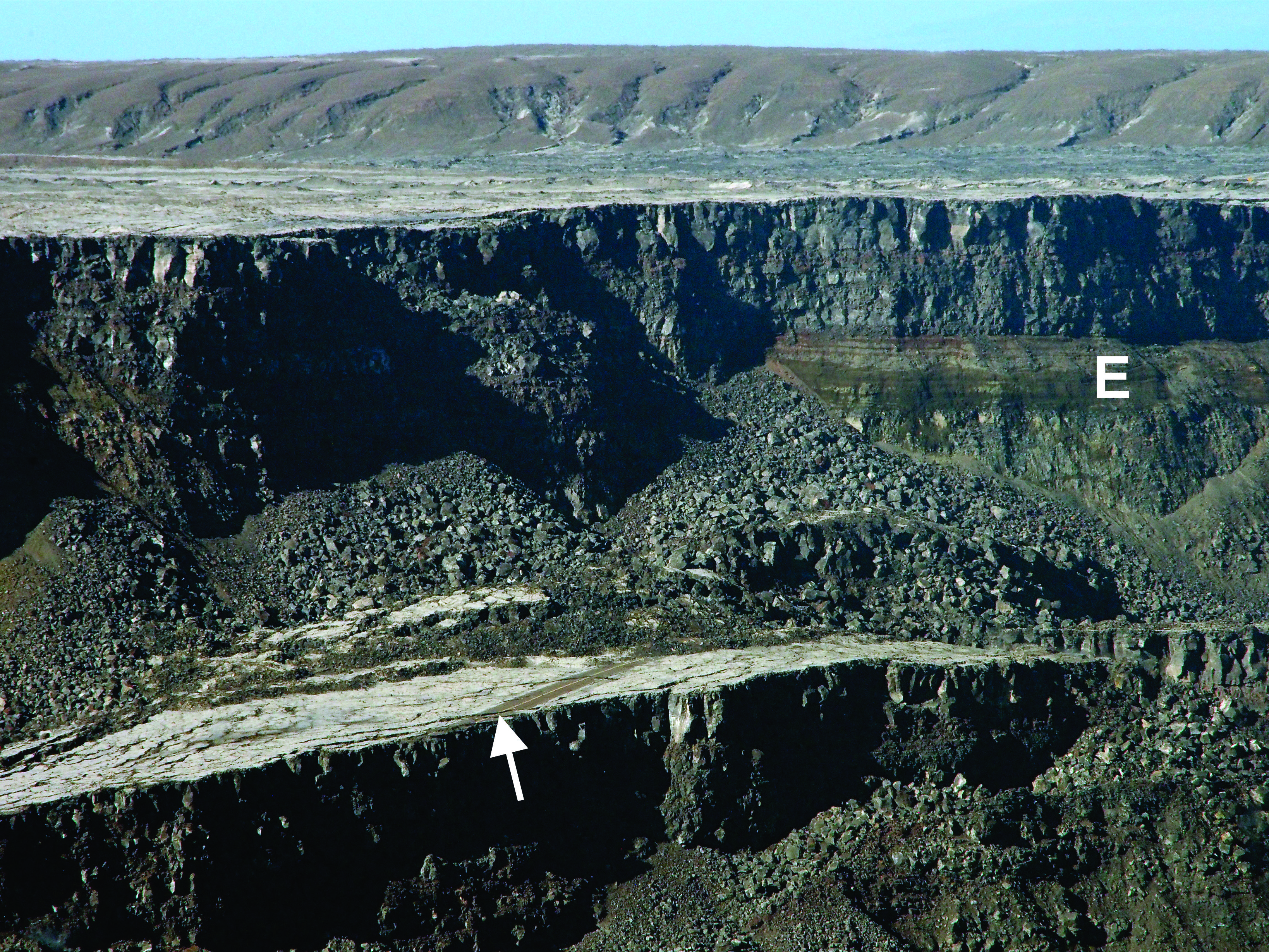
South side of Halemaʻumaʻu at the summit of Kīlauea Volcano, showing a short section of Hawaiʻi Volcanoes National Park’s Crater Rim Drive (arrow) preserved on a block of the former caldera floor that has dropped down about 80 m (260 ft). Thinly bedded Kīlauea explosion deposits (E) from 16th-18th centuries are overlain by 19th and 20th century lava flows in the wall of Halemaʻumaʻu. PC: USGS photo by D. Swanson.
Will this summer’s limited collapse of Kīlauea caldera eventually widen?
The limited collapse of the inner part of Kīlauea Volcano’s caldera this summer fell well short of the larger summit-wide collapses that occurred in the past. How many such limited collapses can we recognize at Kīlauea before written records were kept? The answer is none.
Yes, none. Without written descriptions, we could not identify past small-scale caldera collapses. The reason is that such collapses are confined to the inner part of the caldera itself, exactly where later eruptions and the next collapse take place.
The eruptions partly or completely fill the small collapse depression, and the next small collapse overprints the preceding one, like walking on someone else’s footsteps. We might get a geologic hint of repeated small collapses under favorable circumstances, but usually we are out of luck.
The much larger summit-wide collapses, however, can be identified with careful research. Such collapses are probably less frequent than the limited collapses. Between the summit-wide collapses there is time for, and good reason to expect, intervening explosive eruptions. These eruptions—powered by magmatic gas, steam, or both—deposit ash and coarser debris outside the caldera, creating deposits that form markers helping to distinguish one summit-wide collapse from another.
ARTICLE CONTINUES BELOW AD
ARTICLE CONTINUES BELOW AD
Putting together the evidence for such events is complicated, time-consuming, field-oriented research, but it paid dividends at Kīlauea by recognizing large-scale cyclic behavior of the volcano during the past 2,500 years.
Among other things, we learned that each summit-wide caldera collapse was followed by centuries during which the supply rate of magma to the ground surface was apparently low—only several percent of that for the past 200 years. As a result, only a few lava flows erupted from one of the rift zones outside the caldera.
Within the caldera, however, many explosive eruptions took place. Lava could have erupted in the caldera, but never with sufficient volume to fill the caldera and spill out to form surface flows. Eventually the supply rate increased, the caldera filled, and lava flows erupted along the rift zones. The volcano has been doing this for the past 200 years.
The previous two summit-wide caldera collapses occurred about 2,200 and 500 years ago, respectively. Each of these collapses was immediately preceded by the development of a very large flow field on the flank of Kīlauea.
These two flow fields, the Kīpuka Nēnē (2,200 years ago) and the Ailā´au (mid-15th century), are the largest that we know on Kīlauea in the past 2,500 years—the period of time for which we have good evidence. The eruption that formed the Ailā´au flow field lasted about 60 years; the eruption that formed the Kīpuka Nēnē flow field probably lasted several decades.
ARTICLE CONTINUES BELOW AD
What could be the reason that eruption of a vast flow field preceded a large caldera collapse?
There are two end-member possibilities. One is that rapid melting of rock in the mantle came to an end, so that there was little magma coming up the pipe to replenish magma erupted in a large flow field. The other is that magma continued to ascend but was hijacked before reaching the ground surface, going somewhere else in or below Kīlauea.
What about the large Pu‘u ‘Ō‘ō flow field? That eruption lasted just over 35 years and accumulated a volume equivalent to that of the Kīpuka Nēnē flow field. That makes Pu‘u ‘Ō‘ō either the second or third largest flow field known in the past 2,500 years on Kīlauea.
Since each of the other two large flow fields immediately preceded a summit-wide caldera collapse, is the Pu‘u ‘Ō‘ō flow field sending a message? Will this summer’s small summit collapse eventually resume and ultimately engulf the entire summit?
The geologic evidence is insufficient to tell us how long it took for past large collapses to fully develop. Such collapses could have happened in only a few weeks or could have been spread over years to several decades.
ARTICLE CONTINUES BELOW AD
In this light, this summer’s collapse could be all that will happen—or it could be the start of a longer period of repeated collapses that finally involve the entire summit. We simply can’t tell at this stage. It will probably take decades before we know if the size of the Puʻu ʻŌʻō flow field was a harbinger of major collapse or only a red herring.
Volcano Activity Updates
At Kīlauea’s Lower East Rift Zone (LERZ), no incandescence has been visible within the Fissure 8 cone since Sept. 15. At the summit of the volcano, seismicity and ground deformation remain low. Hazardous conditions still exist at both the LERZ and summit. Residents in the lower Puna District and Kīlauea summit areas on the Island of Hawaiʻi should stay informed and heed Hawai‘i County Civil Defense closures, warnings, and messages.
No collapses at Puʻu ʻŌʻō have been observed since last weekend.
The combined sulfur dioxide emission rates at Kīlauea’s summit, Puʻu ʻŌʻō, and lower East Rift Zone remain at less than 1,000 tonnes per day—lower than at any time since late 2007.
HVO continues to closely monitor both Kīlauea and Mauna Loa and will report any significant changes on either volcano. Daily Kīlauea updates are posted online. Monthly Mauna Loa updates are posted online.
One earthquake with three or more felt reports occurred in the Hawaiian Islands this past week: a magnitude-3.7 quake 30 miles south of Lana’i City at 5 miles depth on Sept. 15, at 12:55 a.m. Small aftershocks from the May 4, 2018, magnitude-6.9 earthquake are still being generated on faults located on Kīlauea’s south flank.
Visit HVO’s website for past Volcano Watch articles, Kīlauea and Mauna updates, volcano photos, maps, recent earthquake info, and more. Call (808) 967-8862 for a Kīlauea summary update. Email questions to [email protected].
Volcano Watchis a weekly article and activity update written by U.S. Geological Survey Hawaiian Volcano Observatory scientists and affiliates.
This comments section is a public community forum for the purpose of free expression. Although Big Island Now encourages respectful communication only, some content may be considered offensive. Please view at your own discretion. View Comments