This news story will be updated throughout the day as new information becomes available and new articles will be added to the website’s “News” section. Previous information about ongoing events can be found in Big Island Now’s “Volcano Blog” section.
CLICK HERE FOR INTERACTIVE LAVA MAP FOR JULY 18, 2018
Wednesday, July 18, 2018, 6:45 p.m.: New Map Released, Lava Close to Pohoiki
Map of the East Rift Zone on July 18, 2018. Click to enlarge. PC: USGS
The south ocean entry area was obscured by laze (acidic steam plume), so the southern boundary of the lava flow is approximate on this map. Given the dynamic nature of Kīlauea’s lower East Rift Zone eruption, with changing vent locations, fissures starting and stopping, and varying rates of lava effusion, map details shown here are accurate as of the date/time noted. Shaded purple areas indicate lava flows erupted in 1840, 1955, 1960 and 2014-2015.
Fissure 8 continues to erupt lava into the perched channel leading northeastward from the vent. An increase in lava supply overnight produced several channel overflows threatening homes on Nohea street and additional overflows downstream on both sides of the channel. The overflows had stalled by mid-morning.
ARTICLE CONTINUES BELOW AD
ARTICLE CONTINUES BELOW AD
South of Kapoho Crater, the surge produced an ʻaʻā flow that rode over the active southern flow that is still entering the ocean. The southern margin of the flow is located about 0.4 miles from the boat ramp at Isaac Hale Park Wednesday, July 18. Despite no visible surface connection to the Fissure 8 channel, lava continues to ooze out at a few points on the 3.7 miles wide flow front into the ocean.
Wednesday, July 18, 2018, 4 p.m.: New Thermal Map Released
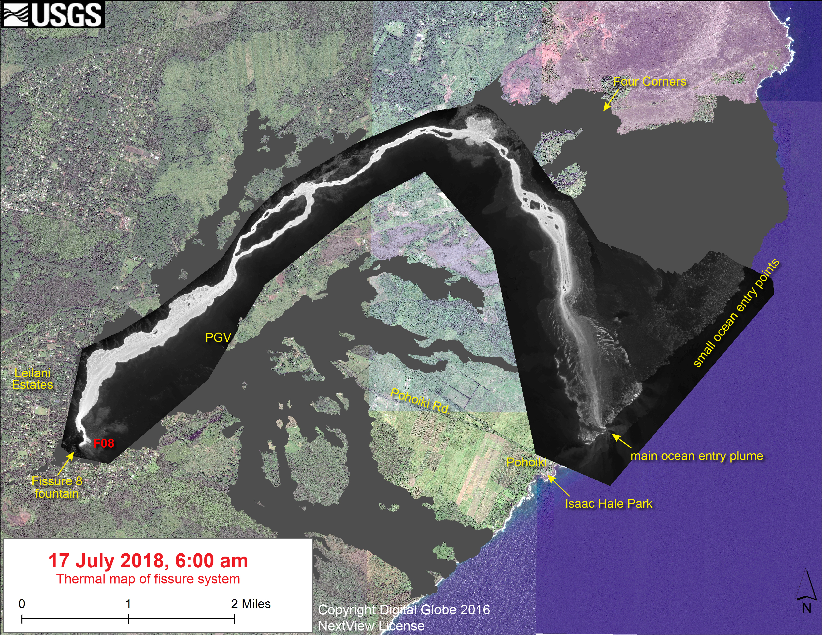
This thermal map shows the East Rift Zone fissure system and lava flows as of 6 a.m. on Tuesday, July 17, 2018. Click to enlarge. PC: USGS
The fountain at Fissure 8 remains active, with the lava flow entering the ocean. The dominant ocean entry was on the new lobe that reached the sea near Ahalanui last week. The black and white area is the extent of the thermal map. Temperature in the thermal image is displayed as gray-scale values, with the brightest pixels indicating the hottest areas. The thermal map was constructed by stitching many overlapping oblique thermal images collected by a handheld thermal camera during a helicopter overflight of the flow field. The base is a copyrighted color satellite image (used with permission) provided by Digital Globe.
The Hawaiian Volcano Observatory reports that eruption activity continues from Fissure 8 into the perched channel, supplying lava flows to the ocean at Ahalanui. Lava is entering the ocean and producing a large laze plume. The southern margin of the flow is .4 miles from Isaac Hale/Pohoiki boat ramp. Channel overflows this morning sent lava flows into Leilani Estates and destroyed additional structures in the closed area along Nohea Street.
The following policies remain in effect:
Do not access the active flow field due to extreme hazard. Be aware that channel overflows and other breakouts are possible on the active flow field.
The ocean entry continues to produce a “laze” plume. Take precautions and stay out of the plume to avoid exposure to hydrochloric acid and glass particles, which can irritate the skin, eyes, and lungs.
The latest air quality measurements from the University of Hawai‘i’s Vog Measurement and Prediction Project can be found online.
ARTICLE CONTINUES BELOW AD
Disaster assistance is available island-wide to individuals and businesses in Hawai‘i County that have been affected by the Kīlauea eruption.
The Disaster Recovery Center, located at the Kea‘au High School Gym, is open daily from 8 a.m. to 6 p.m. weekdays and 8 a.m. to 4 p.m. on Saturdays. If you need a ride, buses run between the two shelters and the Disaster Recovery Center.
Go online for a list of information to bring to the DRC, or to register online.
Access placards are available at the Civil Defense office located at 920 Ululani St.in Hilo.
Wednesday, July 18, 2018, 6 a.m.: Summit Explosion Causes Increased Activity in Leilani Estates
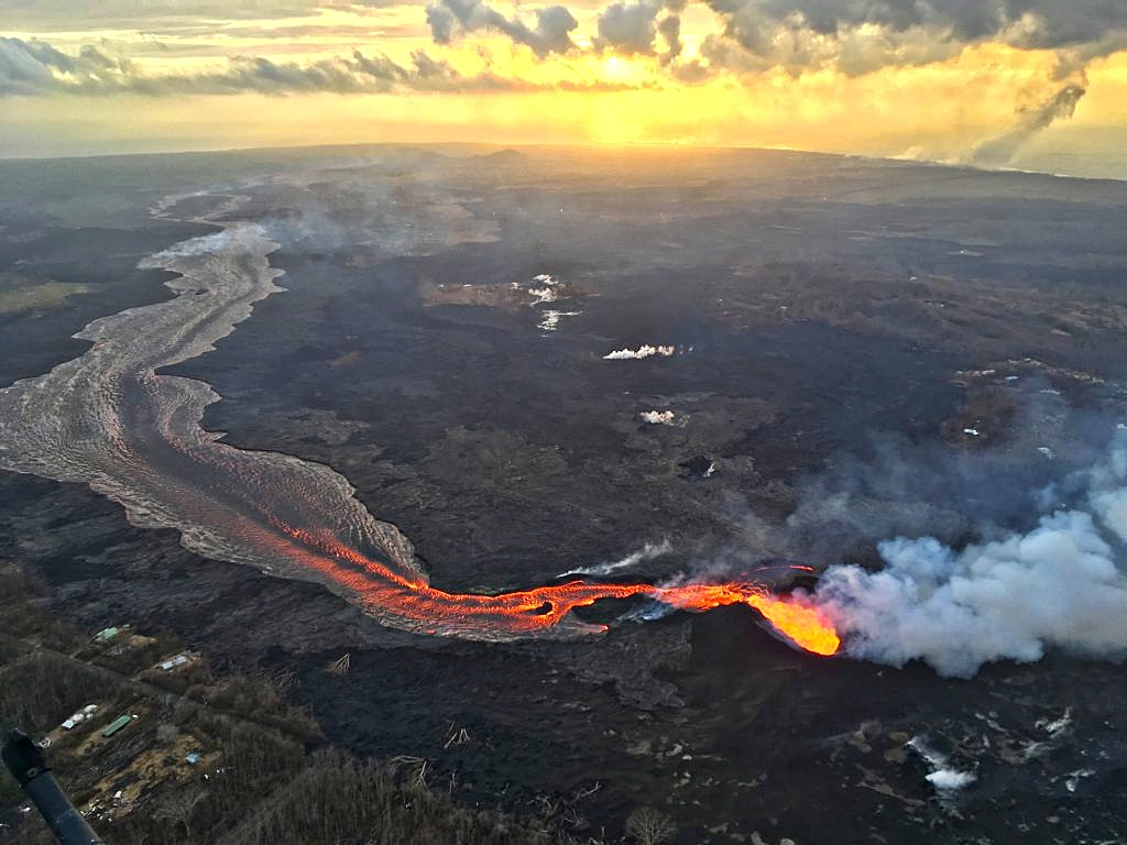
During the Tuesday, July 17, 2018, overflight, USGS scientists captured this image of sunrise above Kīlauea’s lower East Rift Zone. Fissure 8 continues to feed a channelized lava flow that reaches the ocean, forming a large plume at the coast (upper right). Click to enlarge. PC: USGS
Hawaiian Volcano Observatory reports that eruption activity continues at Fissure 8 and is producing a channel flow to the ocean at Ahalanui.
ARTICLE CONTINUES BELOW AD
Lava is entering the ocean and producing a large laze plume.
A collapse explosion from Halema‘uma‘u at 1:28 a.m. resulted in lava flow increase into Leilani Estates with additional structures destroyed.
Due to the hazardous conditions, the following guidance is given:
Keep off the active flow field due to extreme hazards of breakouts.
Stay out of any plumes produced from the fissures and ocean entry.
Monitor the latest air quality measurements through the University of Hawaii’s Vog Measurement and Prediction Project, linked on our Civil Defense Agency website.
Residents of Hawai‘i County who suffered damage or losses from the recent Kīlauea volcanic eruption and earthquakes can now register for disaster assistance with the Federal Emergency Management Agency (FEMA).
VIDEO: Kīlauea Volcano’s Summit: Since early May 2018, the floor of Halema‘uma‘u Crater has dropped about 1480 feet. Extensive cracking and faulting around the crater, along with inward slumping of the crater rim, has more than doubled its diameter. Like a balloon slowly losing air, subsidence occurs because magma in Kīlauea’s shallow summit reservoir is moving into the East Rift Zone more rapidly than magma is being supplied from depth. Images collected during a helicopter overflight of the summit area on July 13, 2018, were used to produce this digital elevation model showing current conditions at Kīlauea
The following is provided for your information:
The Disaster Recovery Center is open Monday to Friday from 8 a.m. to 6 p.m., 8 a.m. to 4 p.m. Saturday and located at the Kea‘au High School Gym.
For a list of the information you need to bring with you to the DRC, or if you want to register online, go to www.DisasterAssistance.gov.
1:45 a.m.: No Tsunami From 5.4-M Summit Collapse Event
Hawaiian Volcanoes Observatory reports a collapse/explosive event with energy equal to a 5.4 magnitude earthquake has occurred at Halema‘uma‘u Crater at 1:28 a.m.
The Pacific Tsunami Warning Center reports there is no tsunami threat to the Island of Hawai‘i.
Due to the volcanic activity, the following is provided for your awareness:
Residents in the area affected by earthquakes are advised to monitor utility connections of gas, electricity, and water after the collapse/explosive event.
When driving be on the lookout for cracks in roadways.
If ash is observed stay indoors or seek cover.
1:31 a.m.: NWS PACIFIC TSUNAMI WARNING CENTER EWA BEACH HI
A SEISMIC EVENT HAS OCCURRED NEAR THE SUMMIT OF KĪLAUEA VOLCANO.
THE EVENT IS LIKELY ASSOCIATED WITH A SUMMIT ERUPTION.
ITS PRELIMINARY PARAMETERS ARE:
ORIGIN TIME – 0128 AM HST 18 JUL 2018
COORDINATES – 19.4 NORTH 155.3 WEST
LOCATION – IN THE SUMMIT REGION OF KILAUEA VOLCANO
MAGNITUDE – 5.4
This comments section is a public community forum for the purpose of free expression. Although Big Island Now encourages respectful communication only, some content may be considered offensive. Please view at your own discretion. View Comments