

3 PM: Gas Explosion at Halema‘uma‘u Crater
This news story will be updated throughout the day as new information becomes available and new articles will be added to the website’s “News” section. Previous information about ongoing events can be found in Big Island Now’s “Volcano Blog” section.
KĪLAUEA SUMMIT LIVESTREAM LINK
CLICK HERE FOR INTERACTIVE LAVA MAP FOR JUNE 30, 2018
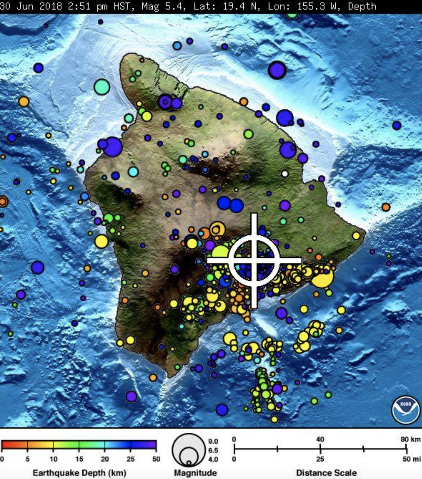
Saturday, June 30, 3 p.m.: Gas Explosion at Halema‘uma‘u Crater
Hawaiian Volcanoes Observatory reports a gas explosion with energy equal to a 5.4 magnitude earthquake has occurred at Halema‘uma‘u Crater at 2:55 p.m.
The Pacific Tsunami Warning Center reports there is no tsunami threat to the Island of Hawai‘i.
Due to the volcanic activity, the following is provided for your awareness:
- Residents in the area affected by earthquakes are advised to monitor utility connections of gas, electricity, and water after earthquakes.
- When driving be on the lookout for cracks in roadways.
- If ash is observed stay indoors or seek cover.
Saturday, June 30, 11 a.m.: New Thermal Map
This thermal map shows the fissure system and lava flows as of 6 a.m. on Friday, June 29, The fountain at Fissure 8 remains active, with the lava flow entering the ocean at Kapoho. Very small, short flows were observed today near Fissure 22.
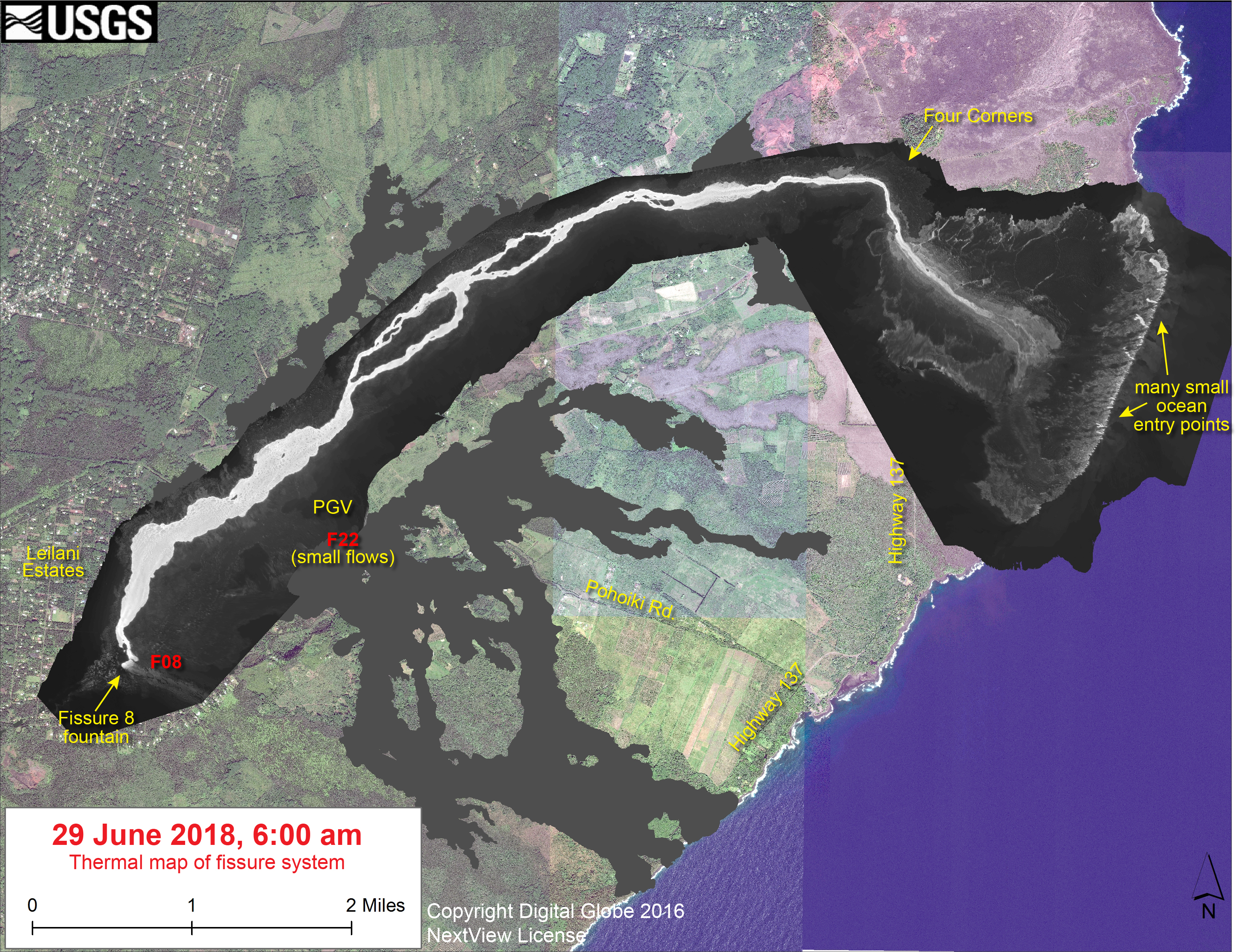
The black and white area is the extent of the thermal map. Temperature in the thermal image is displayed as gray-scale values, with the brightest pixels indicating the hottest areas. The thermal map was constructed by stitching many overlapping oblique thermal images collected by a handheld thermal camera during a helicopter overflight of the flow field. The base is a copyrighted color satellite image (used with permission) provided by Digital Globe.
The eruption in the lower East Rift Zone (LERZ) continues with no significant change during the past 24 hours.
Fountains from Fissure 8 spatter cone continue to supply lava to the open channel with intermittent small, short-lived overflows. These overflows rarely extend beyond the existing flow field. No active overflows were observed during this morning’s helicopter overflight.The spatter cone is now about 180 feet tall at its highest point, and fountains rarely rise above that point. At the coast, the northern margin of the flow field is still oozing fresh lava at several points in the area of Kapoho Beach Lots. Lava was entering the sea over a broad area this morning primarily on the northern side of the entry area. As shown by yesterday’s thermal map of the flow field, the lava channel has crusted over about 0.5 miles inland of the ocean entry; lava is moving beneath the crust and into still-molten interior of earlier flows before it enters the sea in multiple oozeouts.
Pele’s hair and other lightweight volcanic glass fragments from the lava fountain at Fissure 8 continue to fall downwind of the fissure, dusting the ground within a few hundred meters (yards) of the vent. High winds may waft lighter particles to greater distances. Residents are urged to minimize exposure to these volcanic particles, which can cause skin and eye irritation similar to volcanic ash.
Civil Defense Report:
Hawaiian Volcano Observatory reports that Fissure 8 continues to be very active and is feeding a lava channel to the ocean at Kapoho. The flow is producing a broad ocean entry along the shoreline, and is also oozing fresh lava at Kapoho Beach Lots. Fissure 22 is also active and producing a short flow. Gas emissions from the fissure eruption and laze at the ocean entry continue to be very high.
Due to volcanic activity, the following polices are in effect:
- Due to active lava near houses in Kapoho, access by residents is not allowed.
- Due to frequent earthquakes, residents in the Volcano area are advised to monitor utility connections of gas, electricity, and water after earthquakes.
On emergency information:
- Placards for entrance to the affected areas of Puna will be relocated to the Disaster Recovery Center at the Kea‘au High School Gym Monday, July 2, and operate 9 a.m. to 4 p.m. daily.
- Placards will be available at Civil Defense through Sunday, July 1.
- The State Emergency Siren monthly test will be conducted Monday July 2 at 11:45 a.m.
VIDEO: The USGS Unoccupied Aircraft Systems (UAS) team conducted a flight on Kīlauea Volcano’s lower East Rift Zone to collect video in the upper lava channel of Fissure 8 on Friday, June 29, 2018. When it is dark the incandescence (glow) of lava is easy to see against the darkened surroundings. Overnight UAS missions are the most efficient way for geologists to observe the lava channel to identify overflows and breaches of the channel. Scientists also use the video to assess lava flow velocities, which are measured by tracking surface features in the stationary video view. Using UAS for this type of investigation has many advantages because the aircraft can hover above hazardous areas and it utilizes stabilized gimbals and mounts so that the video captured by onboard HD cameras is steady and smooth. Information obtained from this mission was relayed to Hawai‘i County emergency officials to aid in issuing emergency alerts and notices about the timing of evacuations. Video by the U.S. Geological Survey and Office of Aviation Services, Department of the Interior, with support from the Hawaiian Volcano Observatory.
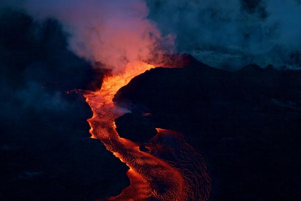
Early morning view of Fissure 8, June 28, 2018. Lava roils and pours out of the spatter cone into the open channel. PC: USGS HVO
Saturday, June 30, 6 a.m.
Hawaiian Volcano Observatory reports that Fissure 8 continues to be very active and is feeding a lava channel to the ocean at Kapoho.
The flow is producing a broad ocean entry along the shoreline, and is also oozing fresh lava at Kapoho Beach Lots.
Fissure 22 is also active and producing a short flow.
Gas emissions from the fissure eruption and laze at the ocean entry continue to be very high. The National Weather Service reports trade winds will push vog to the south and west side of the island.
Due to volcanic activity, the following polices are in effect:
- Due to active lava near houses in Kapoho, access by residents is not allowed.
- Due to frequent earthquakes, residents in the Volcano area are advised to monitor utility connections of gas, electricity, and water after earthquakes.
Disaster assistance is available island-wide to individuals and businesses in Hawai‘i County that have been affected by the Kīlauea eruption.
You can register for disaster assistance with the Federal Emergency Management Agency (also referred to as FEMA) in-person by visiting the Disaster Recovery Center, by calling 1-800-621-3362 (FEMA) or online at disasterassistance.gov.
The Disaster Recovery Center is open daily from 8 a.m. to 8 p.m., and is located at the Kea‘au High School Gym. If you need a ride, buses will resume running between the two shelters and the Disaster Recovery Center between 7:30 a.m. and 9 p.m.
For more resources to help you recover from this disaster, visit the county website.


Sponsored Content

