TheU.S. Geological Survey Hawaiian Volcano Observatory was unable to issue “Volcano Watch” by its regular Thursday deadline on May 3, 2018, due to unfolding events on Kīlauea Volcano. Little did we know that Friday, May 4, would be even more hectic.
How it began: Following a collapse of the Pu‘u ‘Ō‘ō crater floor on Monday, April 30, an intrusion of magma migrated down Kīlauea’s East Rift Zone, advancing below ground toward Highway 130 and communities in the lower Puna District on the Island of Hawaiʻi.
The possibility that the intrusion would lead to an eruption of lava became more likely as numerous small earthquakes shook the area over the next few days.
On May 3, it happened. With little fanfare, steaming ground cracks were soon spewing lava in Leilani Estates.
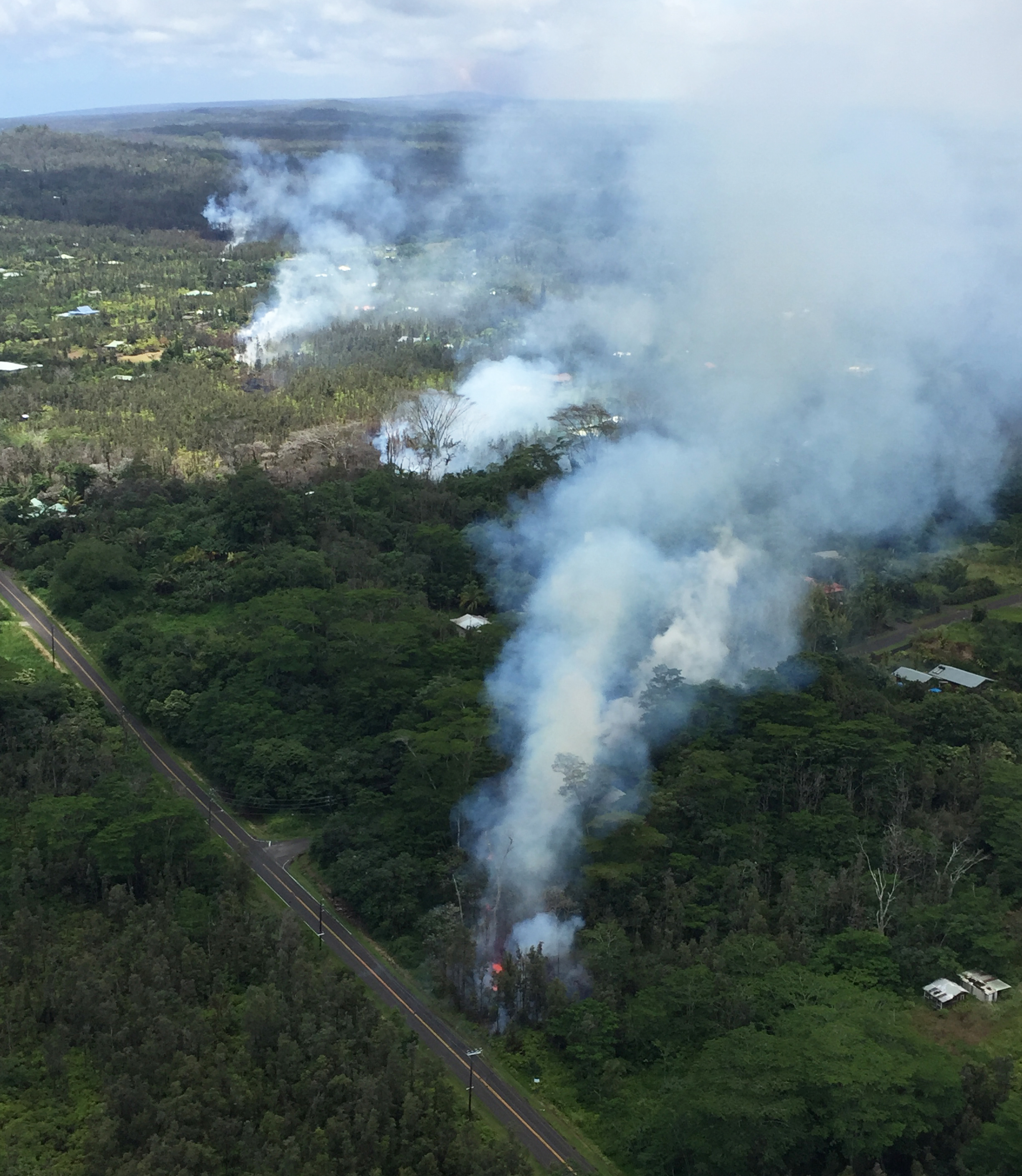
An intrusion of magma into Kīlauea Volcano’s lower East Rift Zone resulted in an eruption in Leilani Estates in the lower Puna District on the Island of Hawaiʻi. The first four fissures to erupt in the subdivision are shown here on May 4, emitting copious amounts of hazardous sulfur dioxide gas. Pu‘u ‘Ō‘ō (top center), which is about 20 km (12.4 mi) uprift of Leilani Estates, can be seen on the far horizon (top center). As of May 6, at least 10 fissures have erupted in the subdivision. USGS photo by T. Neal.
By the morning of May 4, three additional fissures had opened in the subdivision, with lava traveling less than a few tens of yards from the vents.
ARTICLE CONTINUES BELOW AD
ARTICLE CONTINUES BELOW AD
Then, Kīlauea really started rocking and rolling.
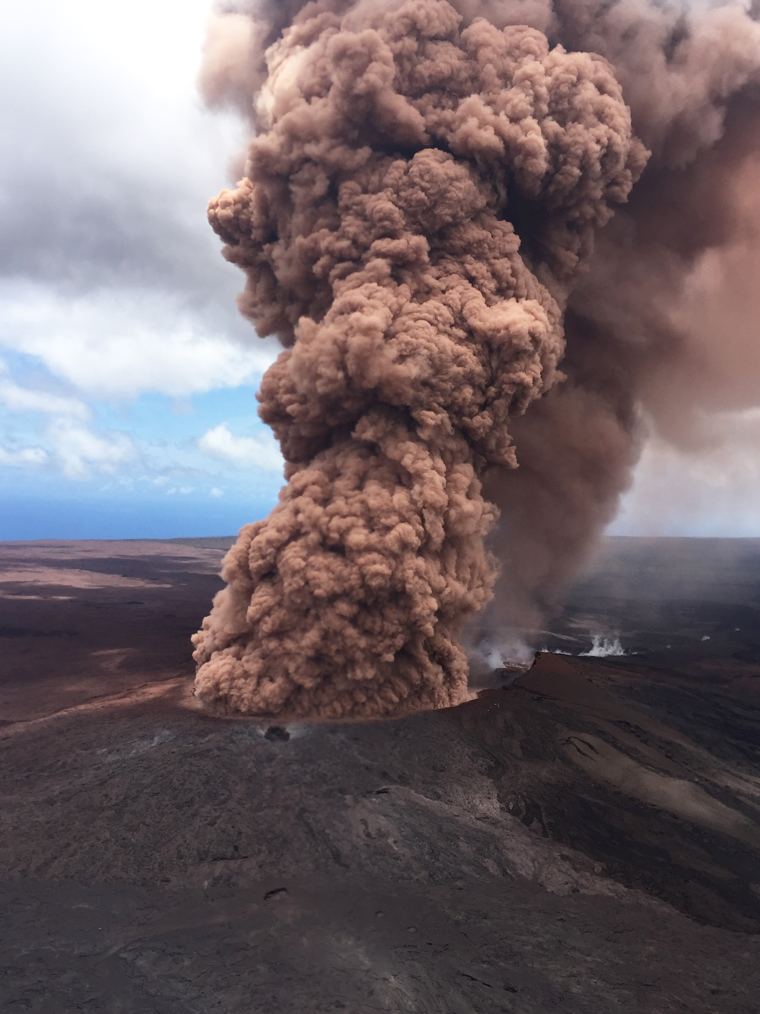
With each large earthquake, ground shaking causes additional collapse within the Pu‘u ‘Ō‘ō crater, sending a plume of reddish-brown ash skyward. The size and vigor of a plume depends on the size of the earthquake and subsequent collapse. This roiling ash plume followed the magnitude-6.9 earthquake on May 4. Much of the rock within the crater is rust in color, which is a result of heavy alteration by acidic volcanic gases. When the rock is pulverized by a collapse event, the resulting ash plume is pink to reddish-brown ash plume. USGS photo by T. Neal.
It began with a magnitude-5.4 earthquake at 11:32 a.m. HST. An hour later, a magnitude-6.9 earthquake, the strongest quake to strike Hawaiʻi since 1975, rattled residents across the island and beyond, with felt reports from as far away as Kaua‘i.
Over the next 24 hours, more than 500 earthquakes—13 with magnitudes of 4 or greater—shook the island.
Over 500 earthquakes were located by the USGS Hawaiian Volcano Observatory (HVO) between noon Friday and noon Saturday, May 4 and 5, 2018. A magnitude-6.9 earthquake at 12:32 p.m. HST on Friday was preceded by two foreshocks with magnitudes of 5.4 and 4.4 at 11:32 a.m. and 11:38 a.m., respectively, and followed by eight aftershocks with magnitudes greater than 4.0, including a magnitude-5.3 at 2:37 p.m. Moderate to strong aftershocks should be expected for weeks to months to come. The earthquakes are related to the ongoing intrusion into Kīlauea’s East Rift Zone and reflect adjustments beneath the south flank of the volcano. USGS map.
In the meantime, the summit of Kīlauea switched from inflation to deflation, and in concert with that deflation, the summit lava lake level began to drop.
ARTICLE CONTINUES BELOW AD
Events of this notable day on Kīlauea are summarized in a photo essay featuring images from May 4.
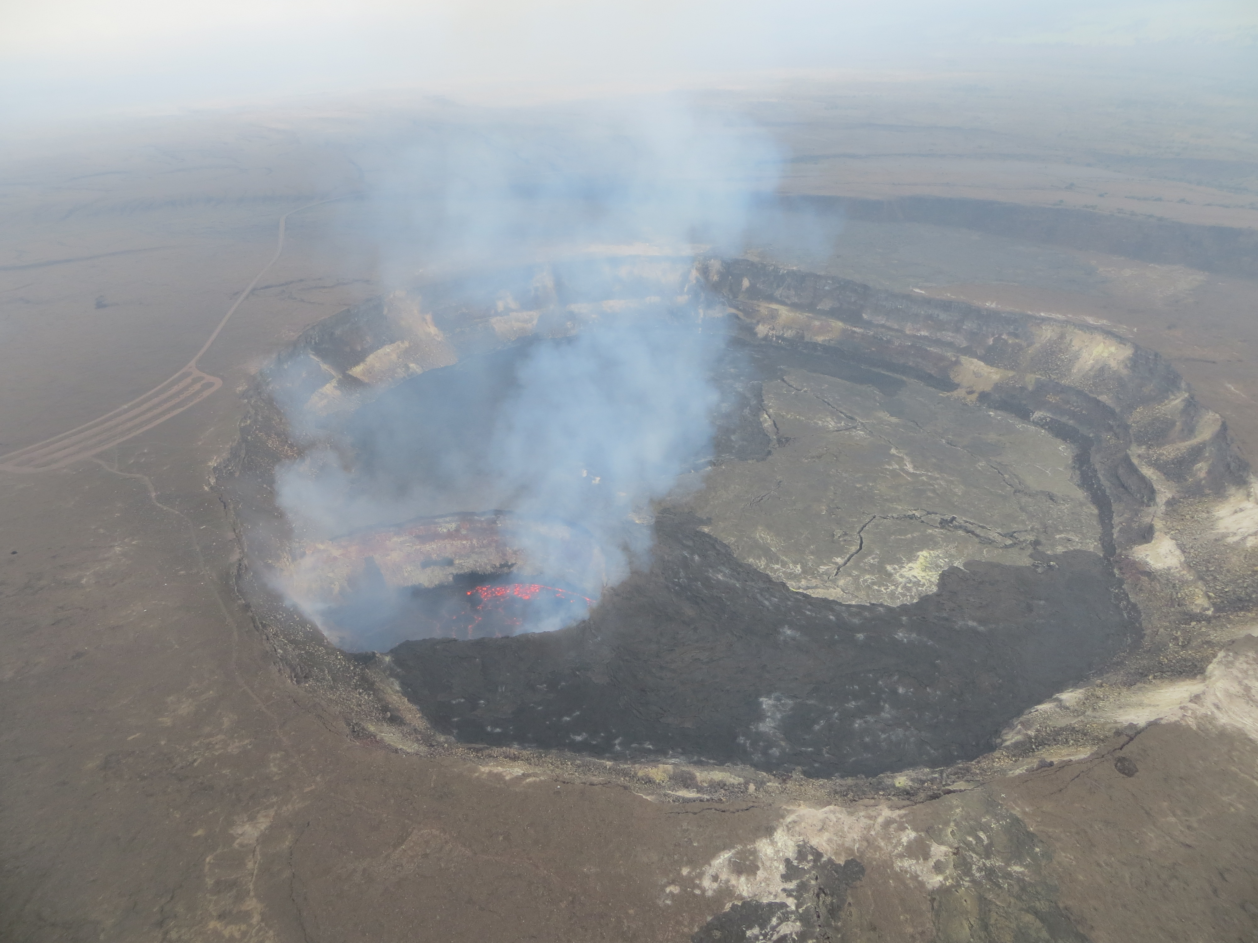
Kīlauea’s summit eruption within Halemaʻumaʻu did not initially respond to the volcano’s East Rift Zone activity (collapse of the Pu‘u ‘Ō‘ō crater floor and magmatic intrusion into the rift zone) on April 30. But on May 2, the lava lake level began to drop in concert with summit deflation, suggesting that magma was moving from the summit into the East Rift Zone. By Friday, May 4, when this photo was taken, the lava lake level had dropped 85 m (279 ft). The lake continues to drop. Lava that spilled from the lake and onto the floor of Halemaʻumaʻu during April 21 to 27 formed the dark-colored flows that can be seen on either side of the lava lake. USGS photo by J.Babb.
Volcano Activity Updates
This past week, Kīlauea Volcano’s summit lava lake level dropped with summit deflation, and was about (525 feet below the vent rim as of May 5 at 9:30 p.m. HST.
On the East Rift Zone, the 61g lava flow is no longer active. Episode 62 commenced on Kīlauea’s lower East Rift Zone on May 3, with at least 10 fissures (as of May 6) opening within the Leilani Estates subdivision in the lower Puna District. Both eruptions, summit and East Rift Zone, are dynamic, and additional changes will be reported on HVO’s website.
ARTICLE CONTINUES BELOW AD
Mauna Loa is not erupting. Rates of deformation and seismicity have not changed significantly over the past week.
More than 100 earthquakes were reported felt in Hawai‘i during the past week. The largest of these earthquakes was a magnitude-6.9 event located about 10 miles southwest of Leilani Estates on the Island of Hawai‘i at a depth of 3.1 miles. It occurred at 12:32 p.m. on May 4, and was one of 14 earthquakes with magnitudes of 4.0 or greater to occur that day.
Visit HVO’s website for past “Volcano Watch” articles, Kīlauea daily eruption updates, Mauna Loa weekly updates, volcano photos, maps, recent earthquake information and more.
Call for summary updates at (808) 967-8862 (Kīlauea) or (808) 967-8866 (Mauna Loa). Email questions to [email protected].
“Volcano Watch” is a weekly article and activity update written by U.S. Geological Survey Hawaiian Volcano Observatory scientists and affiliates.
This comments section is a public community forum for the purpose of free expression. Although Big Island Now encourages respectful communication only, some content may be considered offensive. Please view at your own discretion. View Comments