Hawaiʻi residents may face snow, flash flooding and landslides as a plume of deep tropical moisture is expected to surge northward to Hawaiʻi this week that will provide the fuel for heavier and more frequent downpours for some of the islands.
Hawaiʻi residents and vacationers will need to be on alert.
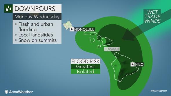
“The first round of heavy rainfall is expected on Monday and Tuesday, with torrential downpours focusing on the Big Island and Maui,” AccuWeather meteorologist Faith Eherts said.
Stronger-than-normal northeasterly trade winds will blow across the islands and up the windward slopes, and by combining with the deep tropical moisture will lead to very heavy rainfall.
ARTICLE CONTINUES BELOW AD
ARTICLE CONTINUES BELOW AD
“Rainfall rates of up to 2 inches per hour can result in dangerous flash flooding as well as landslides, which could topple trees and power lines and block or wash out roads,” Eherts warned.
Rainfall amounts of 3 to 6 inches are expected for Hilo and other windward coastal areas into the midweek, with higher amounts farther inland across the Big Island and Maui.
It will be cold enough across the summits of Maunakea and Mauna Loa for heavy snowfall during this time. A few inches are expected with localized amounts of up to a foot possible. Hikers will need to be vigilant and keep a close eye on weather conditions.
ARTICLE CONTINUES BELOW AD
While rainfall amounts will be less on the leeward side of the islands, moisture may wrap around at times and lead to heavier showers.
Moloka‘i, Oʻahu and Kauaʻi will miss out on the heaviest rain, but a slight uptick in moisture will still bring more numerous and enhanced trade showers over the next few days.
Northeastward-facing coasts will face elevated surf this week thanks to the strong trade winds. Occasional wind gusts of 30 to 40 mph will also occur.
ARTICLE CONTINUES BELOW AD
The first part of the week will be very wet across some of the Hawaiian Islands, but the second half of the week and into the weekend could be just as wet, if not wetter.
Deep tropical moisture will remain strung out over Hawaiʻi and there are indications that an area of low pressure could develop in the area by Friday. If this were to occur, there could be widespread enhanced showers for some or even all of the islands.
“Another round of heavy rain would exacerbate any existing flooding or bring new flooding problems to the other islands,” Eherts said.
This comments section is a public community forum for the purpose of free expression. Although Big Island Now encourages respectful communication only, some content may be considered offensive. Please view at your own discretion. View Comments