Volcano Watch is a weekly article and activity update written by U.S. Geological Survey scientists and affiliates with Hawaiian Volcano Observatory.
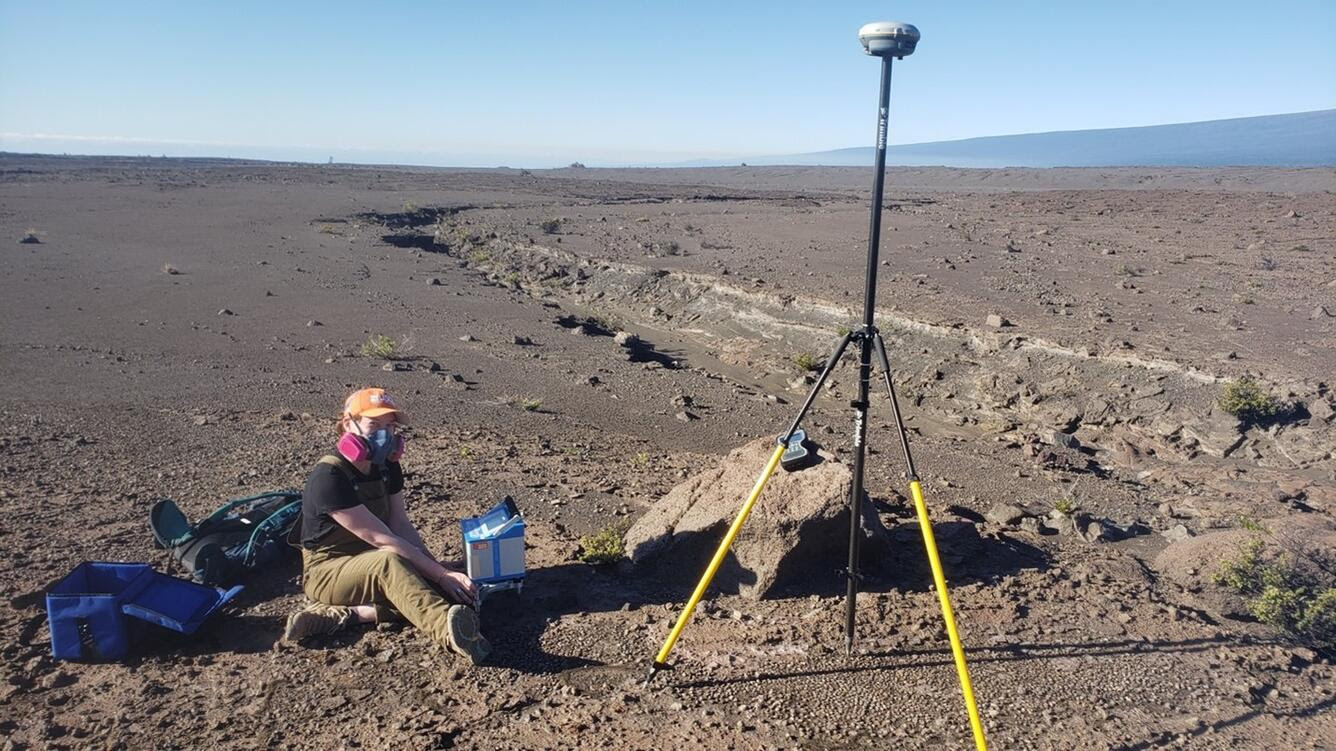
University of Wisconsin—Madison Ph.D. candidate and Hawaiian Volcano Observatory volunteer Claire Ruggles measures variations in the strength of gravity (grey box) and precise location (GPS on antenna) on Jan. 7, 2023 at the summit of Kīlauea. Photo: USGS/HVO geophysicist A. Flinders.
Measurements of gravity can be used to determine how mass is distributed beneath a volcano.
At Kīlauea, the Hawaiian Volcano Observatory performs routine microgravity surveys to monitor volcanic activity and to determine changes in gravity. Those changes can indicate whether magma is accumulating in a volcano’s magma reservoir.
The surveys measure small gravity changes over time at precisely controlled locations called “benchmarks” that are spread across the volcano’s summit region.
The Kīlauea microgravity monitoring network is comprised of about 50 benchmarks. Annual microgravity surveys are crucial in confirming whether ongoing uplift or subsidence is caused by magma intrusion or withdrawal.
ARTICLE CONTINUES BELOW AD
ARTICLE CONTINUES BELOW AD
Hawaiian Volcano Observatory conducts these surveys using small, shoebox-sized instruments called relative gravimeters that can measure a change in the force of gravity to one-in-one billionth of the force you feel every day.
A single gravity measurement consists of leveling a small baseplate (less than 1 foot in diameter and 3 inches tall) on the ground, placing the gravimeter on the baseplate, and making a five-minute measurement. Along with gravity, high-precision positions are also collected using GPS.
Gravimeters are extremely susceptible to vibration, so hard and stable surfaces, like solid rock outcroppings, are required to take a measurement. The measurements are non-invasive and do not disturb the ground.
In addition to tracking changes over time, gravity surveys can be used to map the density characteristics of the ground beneath the surface. These “Bouguer” surveys, named after an 18th-century French geophysicist, measure the gravity at hundreds to thousands of locations at a single point in time and do not need the repeatable location benchmarking or precision of microgravity surveys.
ARTICLE CONTINUES BELOW AD
Bouguer surveys use the same relative gravimeters that are used for microgravity surveys, but measurements are tied to a reference “base station,” where the actual value of gravity has been determined absolutely.
While both microgravity and Bouguer surveys are used to determine how mass is distributed beneath a volcano , microgravity surveys are used to model changes in these parameters, whereas Bouguer surveys can reveal the overall characteristics of the materials at depth.
Two-and three-dimensional Bouguer models can provide insights into the geologic structure of volcanoes including identifying magma reservoirs, intrusions, landslide and collapse piles, and unexposed faults.
At Kīlauea, they’ve also been used to define likely areas of hydrothermal fluid circulation. Together, microgravity and Bouguer data can see subsurface structure and changes within that structure.
ARTICLE CONTINUES BELOW AD
Bouguer surveys have been a routine tool at Kīlauea for more than seven decades, with the two most recent summit surveys performed in 2009 and 2000.
Over the month of January, a three-person team comprised of HVO geophysicist Ashton Flinders, University of Wisconsin at Madison PhD candidate Claire Ruggles, and University of Wisconsin student Sophia Thompson will measure gravity at more than 400 locations around Kīlauea’s summit. Their Bouguer gravity survey will be the first to address significant large-scale changes associated with the 2018 caldera collapse.
Seismic velocity and density are fundamentally related and results from this gravity survey will be used to help refine the model developed from the anticipated summer 2023 Kīlauea summit seismic study.
If you see three orange-shirted scientists hiking around Kīlauea summit this month, carrying a shoebox-sized case and a long pole with a GPS antenna on the top, that’s us. Feel free to stop and say “aloha,” we love to talk about what we’re doing and why.
This comments section is a public community forum for the purpose of free expression. Although Big Island Now encourages respectful communication only, some content may be considered offensive. Please view at your own discretion. View Comments