Hawai‘i residents are likely familiar with the Volcano Activity Updates that the Hawaiian Volcano Observatory (HVO) issues for Kīlauea and other active Hawaiian volcanoes. These updates, which provide situational awareness of volcanic activity and hazards, were formally established in 2006.
In addition to daily, weekly or monthly updates, other types of notifications provided through this service include Volcanic Activity Notices (VANs), Status Reports, Volcano Observatory Notices for Aviation (VONAs) and Information Statements.
Before and during the 2018 Lower East Rift Zone (LERZ) eruption and summit collapse events, HVO used these notification types to alert the public to changing activity at Kīlauea.
Today, we will explain VANs and VONAs. This is timely because just this week, HVO issued a VAN and VONA to communicate a change in status for Mauna Loa Volcano.
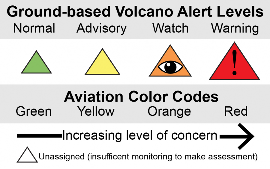
Like updates, VANs and VONAs include the name and location of the volcano and a description of the activity and associated hazards. Each notification lists the Volcano Alert-Level, which informs people on the ground about the volcano’s status, and the Aviation Color Code, which informs the aviation sector about airborne ash hazards.
VANs are released when there is a significant change in volcanic activity. In the lead up to the 2018 LERZ eruption, HVO released four VANs alerting people to changes at Kīlauea and the potential consequences of those changes. On April 17, 2018, a VAN conveyed that Puʻu ʻŌʻō was becoming increasingly pressurized, and hypothesized that a new eruption site might form on or near the Puʻu ʻŌʻō cone as a result.
ARTICLE CONTINUES BELOW AD
ARTICLE CONTINUES BELOW AD
A VAN was then issued on April 24 to let people know that Kīlauea’s summit lava lake in Halemaʻumaʻu was high, and occasionally overflowing, increasing the risk for rockfalls and explosions. In it, HVO extrapolated that if a new vent occurred on or near Puʻu ʻŌʻō, the summit lava lake level would likely drop.
After Puʻu ʻŌʻō collapsed on April 30, 2018, due to the withdrawal of locally-stored magma, HVO released another VAN on May 1. This notice stated that the collapse, along with earthquakes and deformation propagating down Kīlauea’s East Rift Zone, indicated that an outbreak of lava farther downrift was possible.
When lava was observed erupting in the Leilani Estates subdivision on May 3, HVO issued a VAN heralding the start of the 2018 LERZ eruption. This VAN changed the Volcano Alert-Level for Kīlauea from WATCH (escalating unrest or eruption underway with limited hazards) to WARNING (hazardous eruption underway).
With the LERZ eruption fully underway, another VAN was issued on May 9, 2018, confirming HVO’s April 24 forecast that the release of pressure at Puʻu ʻŌʻō would lead to a drop in Kīlauea’s summit lava lake. This VAN emphasized that explosive hazards were possible, including ashfall downwind of the summit.
VONAs are issued when aviation hazards are associated with changes in volcanic activity. They inform pilots, air-traffic controllers, and meteorologists of ash emissions associated with explosive eruptions, including information on height and behavior of the volcanic ash cloud.
ARTICLE CONTINUES BELOW AD
At Kīlauea’s summit, low-level ash emissions were nearly continuous after the lava lake dropped out of view on May 10, 2018, but posed no hazard to aviation. However, on the morning of May 15, ash emissions increased noticeably. In response, HVO issued a VONA—the first ever for Kīlauea—notifying the aviation industry that a 3,000‒3,600-m (10,000‒12,000-ft) plume was transporting ash and vog in a southwest direction.
This VONA was accompanied by a VAN changing Kīlauea Volcano’s Aviation Color Code from ORANGE, denoting an eruption with little to no ash emissions, to RED, signifying that an eruption was underway with significant volcanic ash emissions.
HVO released several more VANs and VONAs in 2018 as dynamic activity continued at Kīlauea’s summit and LERZ. On Oct. 5, 2018, the Aviation Color Code returned to YELLOW and the Volcano Alert-Level was downgraded to ADVISORY, both indicating that volcanic activity had decreased significantly.
On March 26, 2019, with the ongoing eruptive lull on Kīlauea, HVO lowered the Volcano Alert-Level to NORMAL and the Aviation Color Code to GREEN. However, HVO continues to closely monitor volcanic activity and releases Weekly Updates for Kīlauea (and now Mauna Loa) and Monthly Updates for the other active Hawaiian volcanoes.
The USGS Volcano Notification Service is a free service that sends notification emails about volcanic activity at US monitored volcanoes, including Hawaiian volcanoes. HVO encourages all Hawaiʻi residents to sign up to receive these automatic notices at https://volcanoes.usgs.gov/vns2/.
ARTICLE CONTINUES BELOW AD
Graphic caption: The USGS Alert-Notification System for Volcanic Activity includes Volcano Alert Levels, which rank a volcano’s status for people on the ground, and Aviation Color Codes, which rank airborne ash hazards for the aviation sector. This four-tiered system ranges from Normal/Green to Warning/Red to indicate increasing level of concern. To learn more, go online.
For the past several months, earthquake and ground deformation rates at Mauna Loa Volcano have exceeded long-term background levels. An eruption is not imminent and current rates are not cause for alarm. However, they do indicate changes in the shallow magma storage system at Mauna Loa.
Following a significant earthquake swarm in October 2018, HVO seismic stations have recorded an average of at least 50 shallow, small-magnitude earthquakes per week beneath Mauna Loa’s summit, upper Southwest Rift Zone, and upper west flank. This compares to a rate of fewer than 20 per week in the first half of 2018. Shallow earthquakes are occurring in locations similar to those that preceded Mauna Loa’s most recent eruptions in 1975 and 1984.
During this same time period, GPS instrumentation and satellite radar have measured ground deformation consistent with renewed recharge of the volcano’s shallow magma storage system. The current rate and pattern of ground deformation is similar to that measured during inflation of Mauna Loa in 2005 and again from 2014 to 2018.
Together, these observations indicate the volcano is no longer at a background level of activity. Accordingly, HVO elevated the Mauna Loa alert level to ADVISORY and the aviation color code to YELLOW. This increase in alert level does not mean that an eruption is imminent nor that progression to an eruption is certain. A similar increase in activity occurred between 2014 and 2018 and no eruption occurred.
Kīlauea Volcano is not erupting and its USGS Volcano Alert level remains at NORMAL.
Rates of deformation, gas release, and seismicity on Kīlauea have not changed significantly over the past week. Rates of seismicity across the volcano remain low.
Real-time sulfur dioxide emission rates are low at the summit and are below detection limits at Puʻu ʻŌʻō and the lower east rift zone when last measured on June 19 and June 13, respectively.
Since early March, GPS stations and tiltmeters at the Kīlauea summit have recorded deformation consistent with slow magma accumulation within the shallow portion of the Kīlauea summit magma system (approximately 1 mile below ground level). However, gas measurements have yet to indicate significant shallowing of magma. HVO continues to carefully monitor all data streams at the Kīlauea summit for important changes.
Further east, GPS stations and tiltmeters continue to show motions consistent with slowed refilling of the deep East Rift Zone magmatic reservoir in the broad region between Puʻu ʻŌʻō and Highway 130.
Hazards remain at the lower ERZ and summit of Kīlauea. Residents and visitors near the 2018 fissures, lava flows, and summit collapse area should heed Hawaiʻi County Civil Defense and Hawaiʻi Volcanoes National Park closures and warnings. Hawaiʻi County Civil Defense advises that lava flows from the 2018 eruption are primarily on private property; people are asked to be respectful and to not enter or park on private property.
There were two events with three or more felt reports in the Hawaiian islands during the past week: a magnitude-3.7 earthquake 9 miles south of Volcano at 5 miles in depth occurred on July 1, 2019, at 09:37 p.m. HST; a magnitude-2.6 earthquake 9 miles SE of Volcano at 4 miles in depth occurred on June 30, 2019, at 02:43 p.m. HST.
HVO continues to closely monitor both Kīlauea and Mauna Loa for any signs of increased activity.
Visit HVO’s website for past Volcano Watch articles, Kīlauea and Mauna Loa updates, volcano photos, maps, recent earthquake information and more. Call (808) 967-8862 for Kīlauea and Mauna Loa updates. Email questions to [email protected].
“Volcano Watch” is a weekly article and activity update written by the U.S. Geological Survey Hawaiian Volcano Observatory scientists and affiliates.
This comments section is a public community forum for the purpose of free expression. Although Big Island Now encourages respectful communication only, some content may be considered offensive. Please view at your own discretion. View Comments


 Hawai‘i residents are likely familiar with the Volcano Activity Updates that the Hawaiian Volcano Observatory (HVO) issues for Kīlauea and other active Hawaiian volcanoes. These updates, which provide situational awareness of volcanic activity and hazards, were formally established in 2006.


