5 PM, Thursday, June 27, 2019: NWS National Hurricane Center Miami FL
ALVIN BECOMES THE FIRST HURRICANE OF THE 2019 EAST PACIFIC SEASON
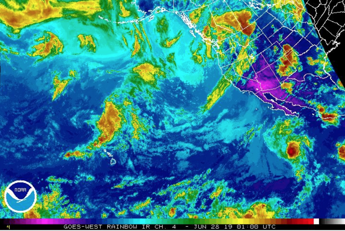
Somewhat surprisingly, Alvin has strengthened into a hurricane this evening. Microwave images show a small eye about 10 nautical miles in diameter.
DISCUSSION AND OUTLOOK
At 5 p.m., the center of Hurricane Alvin was located near latitude 17.4° north, longitude 115.4° west.
ARTICLE CONTINUES BELOW AD
ARTICLE CONTINUES BELOW AD
Alvin is moving toward the NWnear 16 mph, and a gradual turn toward the WNW with a decrease in forward speed is expected over the next couple of days.
Maximum sustained winds have increased to near 75 mph with higher gusts. A weakening trend is expected to begin by early Friday. Alvin is forecast to become a remnant low on Saturday and should dissipate soon thereafter.
Hurricane-force winds extend outward up to 10 miles from the center, and tropical-storm-force winds extend outward up to 45 miles.
The estimated minimum central pressure is 29.30 inches.
The current intensity is 65 knots. Alvin is not expected to maintain this intensity for very long. Within 12 to 24 hours, the cyclone should encounter significantly stronger southwesterly shear.
ARTICLE CONTINUES BELOW AD
Hostile environmental factors should bring about rapid weakening. Alvin is expected to degenerate into a remnant low on Saturday.
The hurricane is moving a little to the right and slightly faster than previous estimates.
Alvin should continue to move near the western periphery of a subtropical ridge for the next 48 hours, with the weakening cyclone gradually turning toward the left and decelerating. The official track forecast is very close to the latest corrected dynamical model consensus.
SUMMARY
LOCATION…17.4N 115.4W
ABOUT 520 MI…840 KM SW OF THE SOUTHERN TIP OF BAJA CALIFORNIA
MAXIMUM SUSTAINED WINDS…75 MPH…120 KM/H
PRESENT MOVEMENT…NW OR 305 DEGREES AT 16 MPH…26 KM/H
MINIMUM CENTRAL PRESSURE…992 MB…29.30 INCHES
ARTICLE CONTINUES BELOW AD
WATCHES AND WARNINGS
There are no coastal watches or warnings in effect.
HAZARDS AFFECTING LAND
None.
NEXT ADVISORY
Next complete advisory at 11 p.m.
11 AM, Thursday, June 27, 2019: NWS National Hurricane Center Miami FL
ALVIN A LITTLE STRONGER BUT EXPECTED TO WEAKEN ON FRIDAY
DISCUSSION AND OUTLOOK
At 11 a.m. HST, the center of Tropical Storm Alvin was located near latitude 16.6 north, longitude 114.2 west. Alvin is moving toward the WNWt near 14 mph and this general motion is expected to continue for the next day or so. A turn toward the west with a decrease in forward speed is expected by late Saturday.
Maximum sustained winds are near 65 mph with higher gusts. Little change in strength is likely tonight, but Alvin is expected to begin weakening on Friday. The tropical storm is forecast to become a remnant low on Saturday and should dissipate soon thereafter.
Tropical-storm-force winds extend outward up to 45 miles from the center.
The estimated minimum central pressure is 29.47 inches.
SUMMARY
LOCATION: 16.6°N 114.2°W
ABOUT 515 MILES SSW OF THE SOUTHERN TIP OF BAJA CALIFORNIA
MAXIMUM SUSTAINED WINDS: 65 MPH
PRESENT MOVEMENT: WNW OR 300 DEGREES AT 14 MPH
MINIMUM CENTRAL PRESSURE: 29.47 INCHES
WATCHES AND WARNINGS
There are no coastal watches or warnings in effect.
HAZARDS AFFECTING LAND
None.
8 AM, Thursday, June 27, 2019: NWS Central Pacific Hurricane Center Honolulu HI
For the central North Pacific between 140°W and 180°W, no tropical cyclones are expected during the next five days.
11 PM, Wednesday, June 26, 2019: NWS National Hurricane Center Miami FL
TINY ALVIN STRENGTHENS OVER THE OPEN PACIFIC OCEAN
DISCUSSION AND OUTLOOK
At 11 p.m. on June 26, the center of Tropical Storm Alvin was located near latitude 15.1 north, longitude 111.9 west.
Alvin is moving toward the WNW near 13 mph and this general motion is expected to continue through Saturday.
Maximum sustained winds have increased to near 60 mph with higher gusts. Some additional strengthening is forecast during the next 24 hours. Weakening is expected to begin on Friday, and Alvin is forecast to become a remnant low on Saturday.
Alvin is a small tropical cyclone. Tropical-storm-force winds extend outward up to 25 miles from the center.
The estimated minimum central pressure is 29.50 inches.
SUMMARY
LOCATION: 15.1N 111.9°W, ABOUT 555 MILES SSW OF THE SOUTHERN TIP OF BAJA CALIFORNIA
MAXIMUM SUSTAINED WINDS: 60 MPH
PRESENT MOVEMENT: WNW OR 300 DEGREES AT 13 MPH
MINIMUM CENTRAL PRESSURE: 29.50 INCHES
WATCHES AND WARNINGS
There are no coastal watches or warnings in effect.
This comments section is a public community forum for the purpose of free expression. Although Big Island Now encourages respectful communication only, some content may be considered offensive. Please view at your own discretion. View Comments