The Hawaiian Volcano Observatory (HVO) reports that a good field geologist is an opportunist. Never content with what outcrops are available, they jump at the chance to see another one, hoping that it will provide a better understanding to some question about what happened in the past.
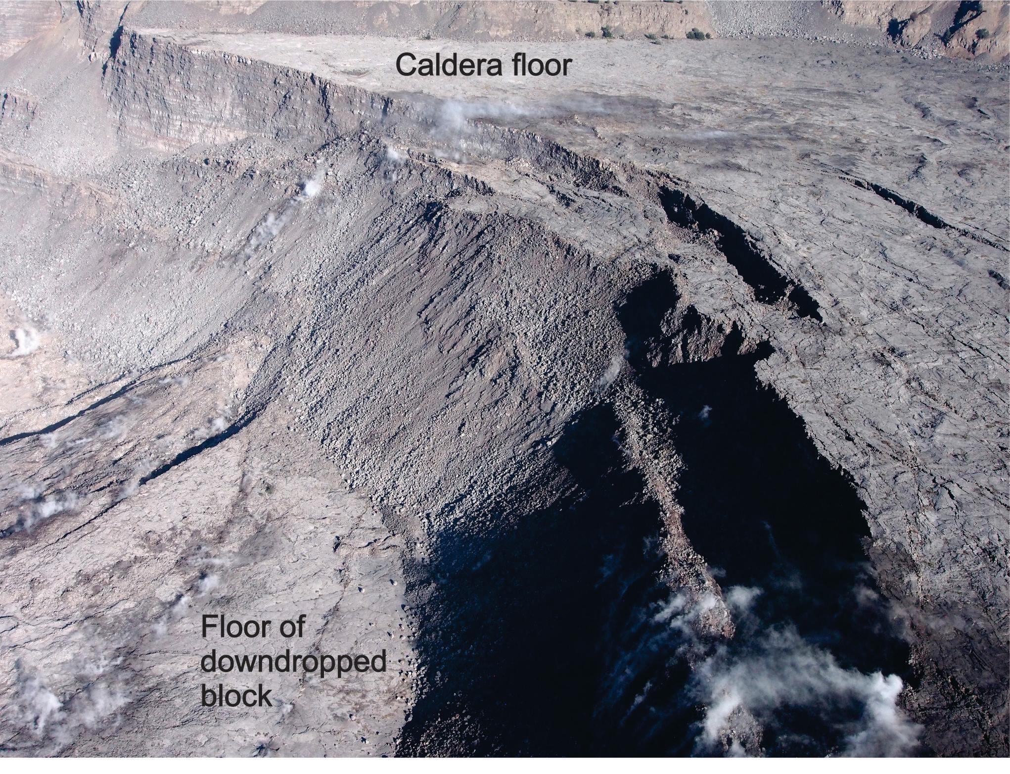
The photo is an aerial view of the western part of Kīlauea Volcano’s caldera, taken on August 6, 2018. The down-dropped block is faulted about 120 m (400 feet) below the caldera floor. Many 19th-century lava flows are exposed in the fault scarps. Halema‘uma‘u (not visible) is to the left of this photo. USGS photo by D.Swanson.
It isn’t every day that new outcrops are created, and rarer still when they are on the scale of those formed during the faulting of Kīlauea Volcano’s caldera floor in summer 2018.
As Halemaʻumaʻu sank and widened, its crater wall began to expose lava flows that formed during earlier eruptions and were covered by later flows. In particular, the north side of Halemaʻumaʻu bites some 1640 feet deeper than before, potentially making accessible lava flows that erupted and gradually filled the caldera early in the 19th century. In addition, the faults that bound the down-dropped sector of the caldera exhumed the south sulfur bank and expose lava flows not previously observed by scientists.
Why are these new outcrops so important? The new exposures provide cross-sections through some of the 19th-century caldera fill. These cross-sections can be examined to look for the margins and floors of ancient lava lakes, spills from those lakes, eruption conduits, and other features leading to a greater understanding of how the caldera was filled.
But, the news isn’t all good. Shaking during the more than 60 large earthquakes last summer caused rockfalls along the west side of the caldera that buried at least one outcrop of explosive deposits more than 1000 years old. Luckily, those deposits had already been sampled.
ARTICLE CONTINUES BELOW AD
ARTICLE CONTINUES BELOW AD
Summer 2018 gave field-focused geologists lots to do and think about in Kīlauea Volcano’s caldera. With new samples and first-hand observations, their work will build on what is already known or surmised and help us better understand the caldera and how its 19th-century activity differed so much from that of the past 100 years.
Activity Summary: Kīlauea Volcano is not erupting. Monitoring data over the past eight months have shown relatively low rates of seismicity, deformation, and gas emission at the summit and East Rift Zone (ERZ) including the area of the 2018 eruption.
Accordingly, the Hawaiian Volcano Observatory (HVO) lowered the Volcano Alert Level for ground-based hazards from ADVISORY to NORMAL. This means the volcano is at a non-eruptive, background state. The Aviation Color Code is was also lowered from YELLOW to GREEN. For more information, psee the Volcano Activity Notice posted on HVO’s web site in the Update section.
For definitions of USGS Volcano Alert Levels and Aviation Color Codes, go online.
ARTICLE CONTINUES BELOW AD
Despite this change, Kīlauea remains an active volcano, and it will erupt again. Although we expect clear signs prior to a return to eruption, the time frame of warning may be short. Island of Hawaiʻi residents should be familiar with the long-term hazard map for Kīlauea Volcano and how to stay informed about Kīlauea activity.
Observations: This past week saw no significant change in monitoring data or volcanic activity. Low rates of seismicity continue across the volcano, with earthquakes occurring primarily in the summit and south flank regions. GPS stations and tiltmeters continue to show motions consistent with refilling of the deep East Rift Zone magma reservoir. Sulfur dioxide emission rates from the summit and from Puʻu ʻŌʻō remain low. These rates have been steady over the past several weeks.
A GPS station on the north flank of Puʻu ʻŌʻō has been showing steady slumping of the craters edge. This motion is not directly related to magmatic activity, but is interpreted to be sliding of the unstable edge of Puʻu ʻŌʻō cone. Small collapses at Puʻu ʻŌʻō have occurred since the eruption due to instability.
ARTICLE CONTINUES BELOW AD
Hazards remain in the lower East Rift Zone eruption area and at the Kīlauea summit. Residents and visitors near the 2018 fissures, lava flows, and summit collapse area should heed Hawaii County Civil Defense and National Park warnings. Hawai‘i County Civil Defense advises that lava flows and features created by the 2018 eruption are primarily on private property and persons are asked to be respectful and not enter or park on private property.
The Hawaiian Volcano Observatory (HVO) continues to closely monitor Kīlauea’s seismicity, deformation, and gas emissions for any sign of increased activity. HVO maintains visual surveillance of the volcano with web cameras and occasional field visits. HVO will continue to issue a weekly update (every Tuesday) until further notice, and we will issue additional messages as warranted by changing activity.
This comments section is a public community forum for the purpose of free expression. Although Big Island Now encourages respectful communication only, some content may be considered offensive. Please view at your own discretion. View Comments