This video was taken during a recent overflight of the Pu‘u ‘Ō‘ō crater on Kīlauea Volcano’s middle East Rift Zone. No major changes were observed at the crater, but its shape continues to be altered by small rockfalls within it. March 18, 2019. VC: USGS HVO
As Hawaiian Volcano Observatory scientists track crater changes over the past 10 months, models show Pu‘u ‘Ō‘ō to be a little wider and not as deep as it used to be, according to a March 18, 2019, USGS Hawaiian Volcano Observatory post.
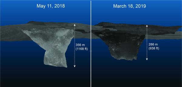
After magma drained from Pu‘u ‘Ō‘ō on April 30, 2018, the crater was roughly 1,168 feet deep, with the upper part of the crater flared and the deeper part a narrower cylindrical shaft.
Collapses of the crater walls have since enlarged sections of the crater and filled the deepest part with rockfall debris, creating a much different crater geometry—as shown in this comparison of models from May 11, 2018, and March 18, 2019. Today, the deepest portion of the crater is 938 feet.
These images are from 3D models of the Pu‘u ‘Ō‘ō crater constructed from thermal images taken during helicopter overflights. After magma drained from Pu‘u ‘Ō‘ō on April 30, 2018, the crater was roughly 356 m (1168 feet) deep, with the upper part of the crater flared and the deeper part a narrower cylindrical shaft. Collapses on the crater walls have since enlarged sections of the crater and filled the deepest part with rockfall debris, creating a much different crater geometry—as shown in this comparison of models from May 11, 2018, and March 18, 2019. Today, the deepest portion of the crater is 938 feet. March 18, 2019. VC: HVO USGS
VIDEO: This 3D model of the Pu‘u ‘Ō‘ō crater, on Kīlauea Volcano’s middle East Rift Zone, was constructed from thermal images taken during a recent helicopter overflight. March 18, 2019. VC: HVO USGS
White areas in the model above show warm spots in the crater, which is now roughly 950 ft deep. Despite the absence of active lava in Pu‘u ‘Ō‘ō, changes at the crater have continued since magma drained from beneath it on April 30, 2018. The shape of the crater continues to change through occasional small collapses within it.
There has been no lava in Pu‘u ‘Ō‘ō since magma drained from beneath it on April 30, 2018.
ARTICLE CONTINUES BELOW AD
The shape of the crater, however, continues to change through occasional small collapses within it. This motion is not directly related to magmatic activity, but is interpreted to be sliding of the unstable edge of Puʻu ʻŌʻō cone.
KILAUEA VOLCANO UPDATE: Tuesday, March 19, 2019, 12:56 PM HST
Current Volcano Alert Level: ADVISORY
Current Aviation Color Code: YELLOW
Activity Summary: Kīlauea Volcano is not erupting. Rates of seismicity, deformation, and gas emissions have not changed significantly over the past week.
ARTICLE CONTINUES BELOW AD
Observations: This past week saw no significant change in volcanic activity. Low rates of seismicity continue across the volcano, with earthquakes occurring primarily in the summit and south flank regions. GPS stations and tiltmeters continue to show motions consistent with refilling of the deep East Rift Zone magma reservoir. Sulfur dioxide emission rates from the summit and from Puʻu ʻŌʻō remain low. These rates have been steady over the past several weeks.
A GPS station on the north flank of Puʻu ʻŌʻō has been showing steady slumping of the craters edge. This motion is not directly related to magmatic activity, but is interpreted to be sliding of the unstable edge of Puʻu ʻŌʻō cone. Small collapses at Puʻu ʻŌʻō have occurred since the eruption due to instability.
Hazards remain in the lower East Rift Zone eruption area and at the Kīlauea summit. Residents and visitors near the 2018 fissures, lava flows, and summit collapse area should heed Hawaii County Civil Defense and National Park warnings. Please note that Hawaii County maintains a closure of the entire lava flow field and eruptive vents, prohibiting access unless authorized through Civil Defense.
The Hawaiian Volcano Observatory (HVO) continues to closely monitor Kīlauea’s seismicity, deformation, and gas emissions for any sign of increased activity. HVO maintains visual surveillance of the volcano with web cameras and occasional field visits. HVO will continue to issue a weekly update (every Tuesday) and additional messages as warranted by changing activity.
This comments section is a public community forum for the purpose of free expression. Although Big Island Now encourages respectful communication only, some content may be considered offensive. Please view at your own discretion. View Comments