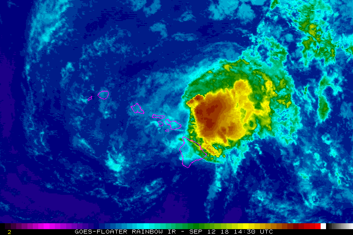
Tropical Storm Olivia made landfall at 9:10 am on Wednesday, Sept. 12, 2018, along the windward coast of the West Maui Mountains, about 10 miles NW of Kahului.
A second landfall occurred on the NW coast of Lāna‘i at 9:54 a.m.
At 11:45 a.m., Olivia was about 60 miles ESE of Honolulu. Olivia will continue westward and is expected to pass south of O‘ahu by early afternoon. Olivia will bring strong winds, heavy rainfall, and high surf to much of the state during the next couple of days.
ARTICLE CONTINUES BELOW AD
ARTICLE CONTINUES BELOW AD
Observations report that sustained winds have increased to 20 to 35 mph with gusts to 45 mph over parts of Maui County this morning.
Tropical storm conditions will be felt across Maui County through the rest of today, spreading to Oahu this afternoon and tonight. The mountainous terrain of the islands will enhance the winds and may produce localized damaging gusts, particularly in the leeward sections of the smaller islands.
Showers and areas of moderate to heavy rain will continue to increase with flooding rainfall a significant threat mainly for O‘ahu and Maui County this afternoon and tonight, and for Kaua‘i and O‘ahu on Thursday and Thursday night.
ARTICLE CONTINUES BELOW AD
Expect storm rainfall totals of 3 to 8 inches, with isolated areas reaching up to 15 inches. Highest rainfall will be focused on windward areas of the islands, especially from Kaua‘i through Maui. However, flooding is still a threat for all areas, particularly as Olivia crosses over the islands today.
Swells and surf generated by Olivia will remain at damaging levels along east facing shores of the smaller islands today. Surf heights along east-facing shores are expected to reach up to 20 feet on O‘ahu, Moloka‘i and Maui. Along the east facing-shores of Kaua‘i and Lāna‘i, expect surf to reach 10 to 14 feet. This surf is expected to result in significant beach erosion and overwash onto vulnerable coastal roadways, particularly during high tides.
WIND: Potential impacts from the main wind event are now unfolding across Maui County and O‘ahu. Remain well sheltered from hazardous wind having possible limited impacts. Elsewhere across the Hawaiian islands, little to no wind impact is anticipated.
ARTICLE CONTINUES BELOW AD
FLOODING RAIN: Potential impacts from the flooding rain are still unfolding across Maui County, O‘ahu and the other Hawaiian Islands. Remain well guarded against life-threatening flood waters having possible devastating impacts.
A Flash Flood Watch remains in effect for the entire state through late Thursday night.
OTHER COASTAL HAZARDS: Large and dangerous surf and strong rip currents will continue along east-facing shores. Prepare for overwash of low-lying areas and roadways with localized beach erosion around high tide. A High Surf Warning is in effect for east-facing shores of the Maui, Moloka‘i and O‘ahu, and a High Surf Advisory is in effect for east facing shores of Lāna‘i and Kaua‘i.
This comments section is a public community forum for the purpose of free expression. Although Big Island Now encourages respectful communication only, some content may be considered offensive. Please view at your own discretion. View Comments