Tuesday, Sept. 11, 2018, 7:30 PM: Olivia Slows; Still On Track for Big Island, Maui
The National Weather Service Central Pacific Hurricane Center reported that Tropical Storm Olivia has slowed down, but is still moving toward the Big Island and Maui County.
Olivia is 90 miles NNE of Hilo.
ARTICLE CONTINUES BELOW AD
ARTICLE CONTINUES BELOW AD
Olivia continues to approach the state from the east. Strong winds, heavy rainfall, and high surf will impact the islands tonight through Thursday.
Winds are already increasing over parts of the Big Island and Maui County ahead of Olivia, and winds will be on the increase over O‘ahu tonight.
More widespread tropical storm force winds and wind gusts are expected to reach portions of the Big Island and Maui overnight, and O‘ahu early Wednesday morning as Olivia draws closer to the state.
Kaua‘i will see winds on the increase late tonight, with more widespread tropical-storm-force winds and wind gusts arriving Wednesday.
The mountainous terrain of the islands will produce localized areas of highly enhanced winds well ahead of Olivia, which can cause damage before the onset of widespread tropical storm force winds.
ARTICLE CONTINUES BELOW AD
Additionally, hurricane force wind gusts are possible with Olivia and with the terrain enhanced winds, well away from the tropical cyclone center.
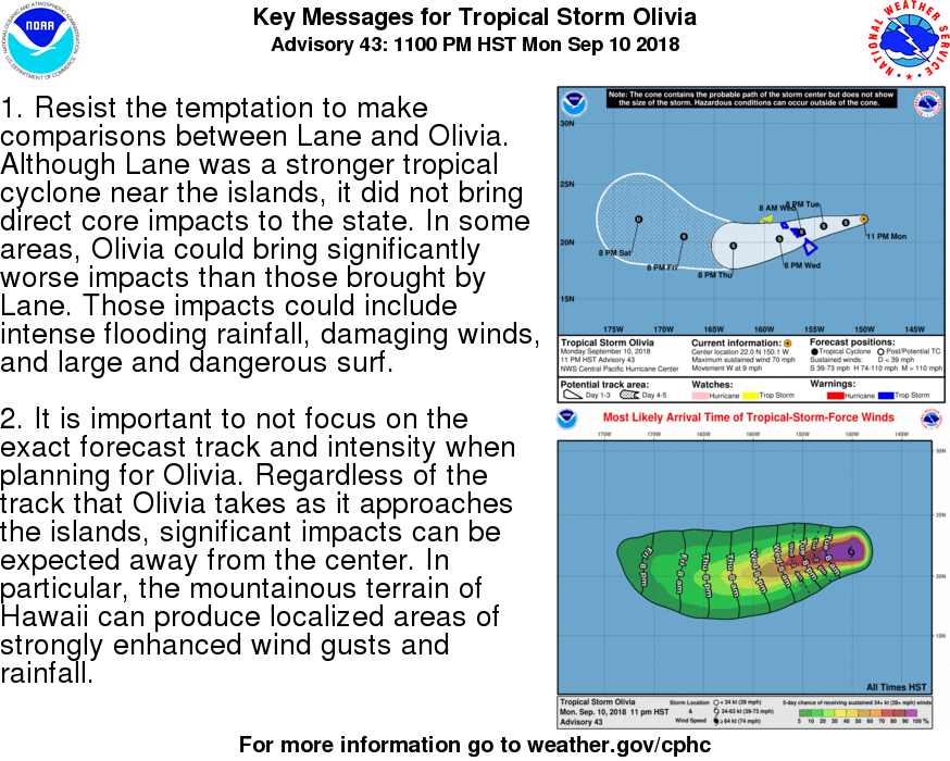
Forecasters say it is important to not focus on the exact forecast track and intensity of Olivia. Regardless of the track that Olivia takes as it approaches the islands, significant impacts can be expected away from the center.
Showers will continue to increase tonight with the chance for flooding rainfall increasing rapidly overnight, and remaining a significant threat through Thursday night.
Expect rainfall totals of 5 to 10 inches, with isolated areas reaching up to 15 inches. Much of this rainfall will be focused on windward areas of the islands, especially from the Big Island through O‘ahu. However, flooding is still a significant threat for all areas, particularly as Olivia moves over
the islands.
Swells and surf generated by Olivia will continue to build along east-facing shores, reaching damaging levels overnight and Wednesday.
ARTICLE CONTINUES BELOW AD
Surf heights along east facing shores are expected to reach 12 to 20 feet on the Big Island, Maui, Molokai and O‘ahu.
Along the east-facing shores of Kaua‘i and Lana‘i, expect surf to reach 10 to 14 feet.
This surf is expected to result in significant beach erosion and overwash onto vulnerable coastal roadways, particularly during high tides.
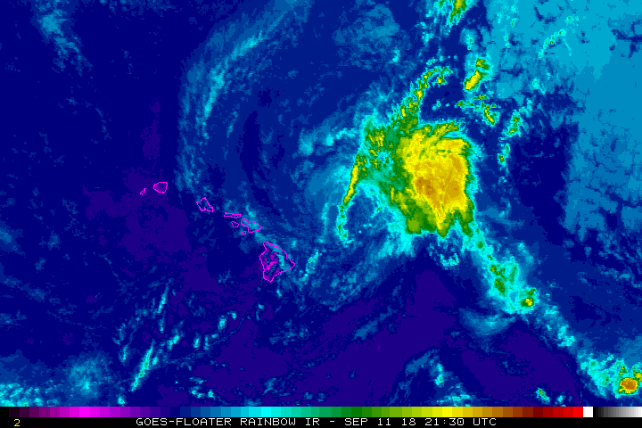
7 PM
TS Olivia, Sept. 11, 2018, 6:30 p.m.
The Central Pacific Hurricane Center reports that as of 5 p.m., Tropical Storm Olivia is located 100 miles NE of Hilo, with sustained winds of 50 mph, moving west at 15 mph. The National Weather Service forecasts strong winds throughout the evening and overnight, especially for the northern half of Hawai‘i Island. Heavy rainfall and flash flooding is also possible.
Due to the Tropical Storm Warning for Hawaii Island, the following advisories are in effect:
A high probability of tropical storm force winds are expected anytime.
High Surf Warning for east facing shores of Hawaii Island, from Cape Kumukahi to Upolu Point.
Flash Flood Watch for Hawaii Island. Do not cross fast flowing water in your vehicle or on foot. Turn around, don’t drown!
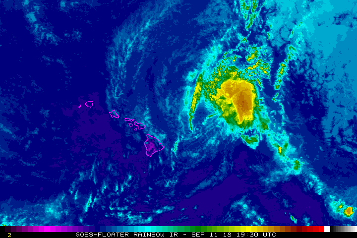
5 PM: Center of Olivia Approaches Big Island, Maui
TS Olivia, Sept. 11, 2018, 4:30 p.m.
The NWS Central Pacific Hurricane Center in Honolulu issued an update on Tropical Storm Olivia.
At 5 p.m., the center of Tropical Storm Olivia was located near latitude 20.9 north, longitude 154.2 west, about 100 miles NE of Hilo.
Olivia is moving toward the west near 15 mph. A general WSW motion with a slower forward speed is expected this evening as the center of Olivia approaches the Big Island and Maui.
After Olivia moves past the islands, a somewhat faster WSW motion is expected to resume and continue for the next couple of days.
Maximum sustained winds are near 50 mph with higher gusts.
Gradual weakening is forecast during the next 48 hours, but Olivia is expected to remain a tropical storm as it moves over the main Hawaiian Islands.
Tropical-storm-force winds extend outward up to 105 miles, mainly to the north of the center.
HAZARDS AFFECTING LAND
WIND: Tropical storm conditions are expected over portions of Maui County and the Big Island starting this evening. Tropical storm conditions are expected over Oahu starting tonight. Tropical storm conditions are expected over Kauai County starting Wednesday. Remember that wind gusts can be much stronger near higher terrain, particularly through gaps between mountains and where winds blow downslope.
RAINFALL: Showers will continue to increase over portions of the main Hawaiian Islands tonight and Wednesday. Olivia is expected to produce total rainfall accumulations of 5 to 10 inches in some areas, with isolated maximum amounts of 15 inches possible, especially in higher terrain. This rainfall may produce life-threatening flash flooding.
SURF: Large swells generated by Olivia will impact the main Hawaiian Islands over the next couple of days. This will result in dangerously high and potentially damaging surf, mainly along exposed east facing shores.
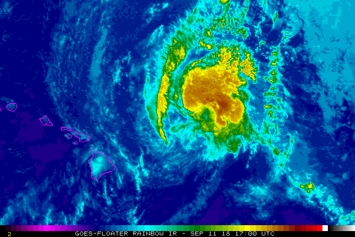
2 PM: Winds to Increase in North Half of Big Island
The Central Pacific Hurricane Center reports that as of p.m., Tropical Storm Olivia is located 135 miles NE of Hilo, with sustained winds of 55 mph, moving WSW at 21 mph. The National Weather Service forecasts increasing wind speeds throughout the afternoon and overnight, particularly for the northern half of Hawai‘i Island.
The following advisories are in effect:
A Tropical Storm Warning is issued when there is a high probability of tropical storm force winds expected anytime within the next 36 hours.
High Surf Warning for east facing-shores of Hawaii Island, from Cape Kumukahi to Upolu Point.
Flash Flood Watch for Hawai‘i Island. Do not cross fast flowing water in your vehicle or on foot. Turn around don’t drown!
TS Olivia, Sept. 11, 2018, 1 p.m. NOAA
The National Weather Service Central Pacific Hurricane Center reported that winds are increasing over the Big Island and Maui County as Tropical Storm Olivia quickly approaches.
At 2 p.m., the center of Tropical Storm Olivia was located near latitude 21.2 north, longitude 153.8 west, 135 miles NE of Hilo.
Olivia is moving toward the west-southwest near 21 mph. This general motion will then continue for the next couple of days. On the forecast track, Olivia will be moving across the main Hawaiian Islands tonight and Wednesday.
Maximum sustained winds are near 55 mph, with higher gusts. Gradual weakening is forecast during the next 48 hours, but Olivia is expected to remain a tropical storm as it moves over the main Hawaiian Islands.
Tropical-storm-force winds extend outward up to 90 miles from the center.
HAZARDS AFFECTING LAND
WIND: Tropical storm conditions are expected over portions of Maui County and the Big Island later today or tonight. Tropical storm conditions are expected over Oahu starting tonight. Tropical storm conditions are possible over Kauai County starting late tonight or Wednesday morning. Wind gusts can be much stronger near higher terrain, particularly through gaps between mountains and where winds blow downslope.
RAINFALL: Showers will continue to increase over portions of the main Hawaiian Islands late this afternoon and evening ahead of Tropical Storm Olivia. Olivia is expected to produce total rainfall accumulations of 5 to 10 inches in some areas, with isolated maximum amounts of 15 inches possible, especially in higher terrain. This rainfall may produce life-threatening flash flooding.
SURF: Large swells generated by Olivia will impact the main Hawaiian Islands over the next couple of days. This will result in dangerously high and potentially damaging surf, mainly along exposed east facing shores.
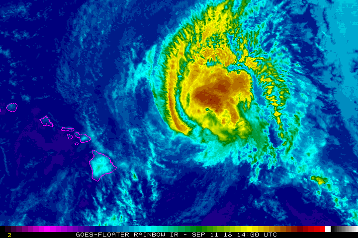
11 AM: Olivia Speeds Up as It Closes in on Hawaiian Islands
TS Olivia, Sept. 11, 2018, 11 a.m. NOAA
The NWS Central Pacific Hurricane Center Honolulu reported that Tropical Storm Olivia is speeding up and closing in on Hawai‘i.
Increasing winds and showers are expected as early as this afternoon.
A Tropical Storm Warning is in effect for Hawai‘i County, Maui County and now, Kaua‘i and Ni‘ihau.
A Tropical Storm Warning means that tropical storm conditions are expected somewhere in the warning area within 36 hours.
At 11 a.m., the center of Tropical Storm Olivia was located near latitude 21.6 north, longitude 152.3 west about 275 miles east of Kahului, Maui.
Olivia is moving toward the west near 17 mph. A slight turn toward the west-southwest is expected later today. This general motion will then continue for the next couple of days. On the forecast
track, Olivia will be moving across the main Hawaiian Islands tonight and Wednesday.
Maximum sustained winds are near 60 mph, with higher gusts. Some weakening is forecast during the next 48 hours. Gradual weakening is forecast during the next 48 hours, but Olivia is expected to remain a tropical storm as it moves over the main Hawaiian Islands.
Tropical-storm-force winds extend outward up to 90 miles from the center.
HAZARDS AFFECTING LAND
WIND: Winds will increase over parts of the main Hawaiian Islands this afternoon as Olivia approaches. Wind gusts can be much stronger near higher terrain, particularly through gaps between mountains and where winds blow downslope. Tropical storm conditions are expected over portions the Big Island and Maui County starting later today or tonight. Tropical storm conditions are expected over O‘ahu starting tonight. Tropical storm conditions are possible over Kauai County starting late tonight or Wednesday
morning.
RAINFALL: Showers will continue to increase over portions of the main Hawaiian Islands today ahead of Tropical Storm Olivia. Olivia is expected to produce total rainfall accumulations of 5 to 10 inches in some areas, with isolated maximum amounts of 15 inches possible, especially in higher terrain. This rainfall may produce life-threatening flash flooding.
SURF: Large swells generated by Olivia will impact the main Hawaiian Islands over the next couple of days. This will result in dangerously high and potentially damaging surf, mainly along exposed east facing shores.
8 AM: Significant Impacts Expected From Olivia
TS Olivia, Sept. 11, 2018, 7:30 a.m. NOAA
A Tropical Storm Warning is in effect for Hawai‘i County, Maui County and O‘ahu.
Tropical Storm Olivia will hit Hawai‘i from the NE on an unusual path that will bring the likelihood of flooding and mudslides spanning Tuesday night and Wednesday.
Rainfall will be significantly less on the Big Island, when compared to Lane, Accuweather reported today.
AccuWeather Hurricane Expert Dan Kottlowski pointed out that since Olivia is moving at a much quicker pace than Lane, this will keep rainfall totals on the Big Island from reaching the same historic levels from late August.
However, Maui may receive about the same amount of rain from Olivia as it did from Lane and Moloka’i and O’ahu may exceed the rainfall the islands received during the late-August encounter.
“Rainfall amounts of 8 to 12 inches are possible, especially over the higher elevations of Maui and the Big Island, with… 20 inches possible in the mountains,” AccuWeather Meteorologist Steve Travis said.
At 8 a.m., the center of Tropical Storm Olivia was located near latitude 21.6 north, longitude 151.9 west, 240 miles ENE of Kahului, Maui.
Olivia is still moving toward the west near 10 mph. A turn to the WSW is expected later today, with a slight increase in forward speed. This general motion will then continue for the next couple of days. On the forecast track, the center of Olivia will be moving the main Hawaiian Islands late tonight into Wednesday.
Maximum sustained winds are near 65 mph, with higher gusts. Gradual weakening is forecast during the next 48 hours, but Olivia is expected to remain a tropical storm as it moves over the islands.
Tropical-storm-force winds extend outward up to 90 miles from the center.
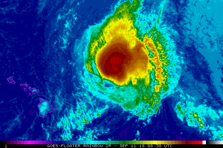
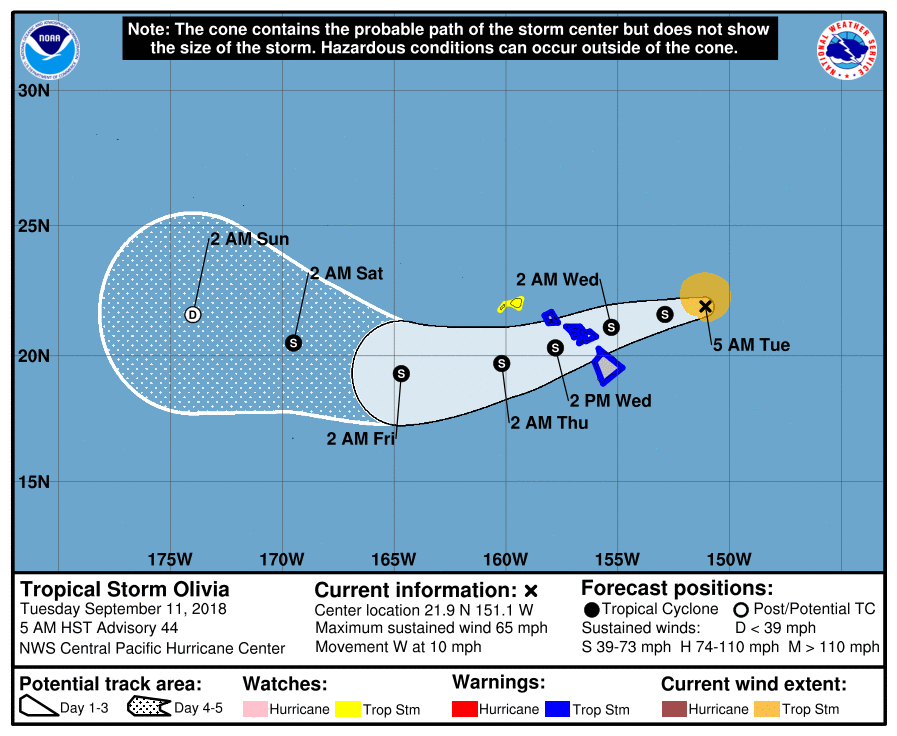
5 AM: Significant Impacts Expected From Olivia
TS Olivia, Sept. 11, 2018, 5:30 a.m. NOAA
The National Weather Service Central Pacific Hurricane Center in Honolulu Tropical Storm Olivia reported that Tropical Storm Olivia has weakened overnight, with 65 mph winds.
A Tropical Storm Warning is in effect for Hawai‘i County, Maui County and O‘ahu. A Tropical Storm Warning means that tropical storm conditions are expected somewhere in the warning area within 36 hours.
A Tropical Storm Watch is in effect for Kaua‘i and Ni‘ihau. A Tropical Storm Watch means that tropical storm conditions are possible in the watch area within 48 hours.
At 5 a.m., the center of Tropical Storm Olivia was located near latitude 21.9 north, longitude 151.1 west, about 300 miles ENE of Hilo and 355 miles ENE of Kahului, Maui.
Olivia is moving toward the west near 10 mph. A turn to the WSW is expected later today, with a slight increase in forward speed. This general motion will then continue for the next couple of days. On the forecast track, the center of Olivia will be moving over portions of the main Hawaiian Islands late
tonight into Wednesday.
Maximum sustained winds are near 65 mph, with higher gusts. Gradual weakening is forecast during the next 48 hours, but Olivia is expected to remain a tropical storm as it moves over the islands.
Tropical-storm-force winds extend outward up to 90 miles from the center.
HAZARDS AFFECTING LAND
WIND: Tropical storm conditions are expected over Maui County and the Big Island starting this evening. Tropical storm conditions are expected over Oahu starting Wednesday morning. Tropical storm conditions are possible over Kauai County starting Wednesday afternoon or evening.
RAINFALL: Olivia is expected to produce total rainfall accumulations of 10 to 15 inches, with isolated maximum amounts of 20 inches possible, especially in higher terrain. This rainfall may produce life-threatening flash flooding.
SURF: Large swells generated by Olivia will impact the main Hawaiian Islands over the next couple of days. This will result in dangerously high and potentially damaging surf, mainly along exposed east facing shores.
BELOW: HIGHLIGHTS FROM THE 5 PM NWS LOCAL AREA UPDATE
This comments section is a public community forum for the purpose of free expression. Although Big Island Now encourages respectful communication only, some content may be considered offensive. Please view at your own discretion. View Comments