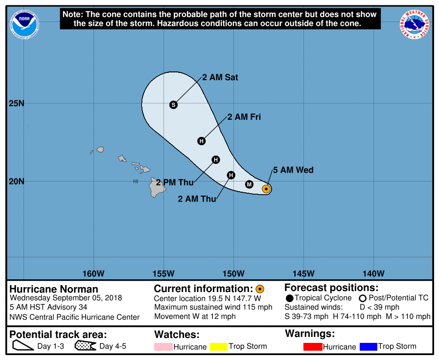
The National Weather Service Central Pacific Hurricane Center in Honolulu issued an updated on Category 3 Hurricane Norman at 5 a.m. on Wednesday, Sept. 5, 2018.
The center of Hurricane Norman is located near latitude 19.5 north, longitude 147.7 west, about 480 miles E of Hilo.
Norman is moving toward the west near 12 mph, and this general motion is expected to continue through this morning.
Norman is expected to slow its forward motion slightly, and turn toward the WNW later today and tonight. A turn toward the northwest is expected Thursday and Thursday night.
ARTICLE CONTINUES BELOW AD
ARTICLE CONTINUES BELOW AD
Maximum sustained winds have increased to near 115 mph, with higher gusts. Some fluctuations in intensity are possible today, followed by gradual weakening from tonight through Thursday night.
Norman is expected to remain a hurricane through Thursday.
Hurricane-force winds extend outward up to 30 miles from the center and tropical-storm-force winds extend outward up to 125 miles.
HAZARDS AFFECTING LAND
ARTICLE CONTINUES BELOW AD
SURF: Large swells generated by Norman will continue to spread from east to west across the Hawaiian Islands during the next couple of days. Large and potentially dangerous surf produced by these swells is expected along east-facing shores through Thursday night.
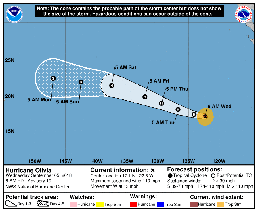
The NWS NHC in Miami, Floriday, reported at 5 a.m. that Hurricane Olivia has weakened to a to Category 3.
The center of Hurricane Olivia is located near latitude 17.1 north, longitude 122.3 west, about 900 miles WSW of the southern tip of Baja, California.
ARTICLE CONTINUES BELOW AD
Olivia is moving toward the west near 13 mph, and this motion is expected to continue today. A turn toward the WNW is expected tonight, followed by a gradual turn back toward the west over the
weekend.
Maximum sustained winds have decreased to near 110 mph, with higher gusts.
Additional slow weakening is expected during the next few days.
Hurricane-force winds extend outward up to 25 miles from the center and tropical-storm-force winds extend outward up to 90 miles.
This comments section is a public community forum for the purpose of free expression. Although Big Island Now encourages respectful communication only, some content may be considered offensive. Please view at your own discretion. View Comments


 The National Weather Service Central Pacific Hurricane Center in Honolulu issued an updated on Category 3 Hurricane Norman at 5 a.m. on Wednesday, Sept. 5, 2018.