This news story will be updated throughout the day as new information becomes available and new articles will be added to the website’s “News” section. Previous information about ongoing events can be found in Big Island Now’s “Volcano Blog” section.
CLICK HERE FOR INTERACTIVE LAVA MAP FOR JULY 11, 2018
Wednesday, July 11, 2108, 5 p.m.: Three More Homes Destroyed
Hawaiian Volcano Observatory reports that Fissure 8 continues to erupt lava into the perched channel heading northeast from the vent. A flow moving around the west side of Kapoho Cone has proceeded to 0.25 miles from Ahalanui Park.
Break outs that occurred earlier today in Leilani Estates have stalled but destroyed three homes in the area.
ARTICLE CONTINUES BELOW AD
ARTICLE CONTINUES BELOW AD
The following policies remain in effect:
Be aware that spill overs of the flow channel and other breakouts are possible on the active flow field, do not access the active flow field due to extreme hazard.
Disaster assistance is available island-wide to individuals and businesses in Hawaii County that have been affected by the Kīlauea eruption.
The Disaster Recovery Center is open daily from 8 a.m. to 6 p.m. weekdays and 8 a.m. to 4 p.m. weekends, and is located at the Kea‘au High School Gym. If you need a ride, buses will resume running between the two shelters and the Disaster Recovery Center.
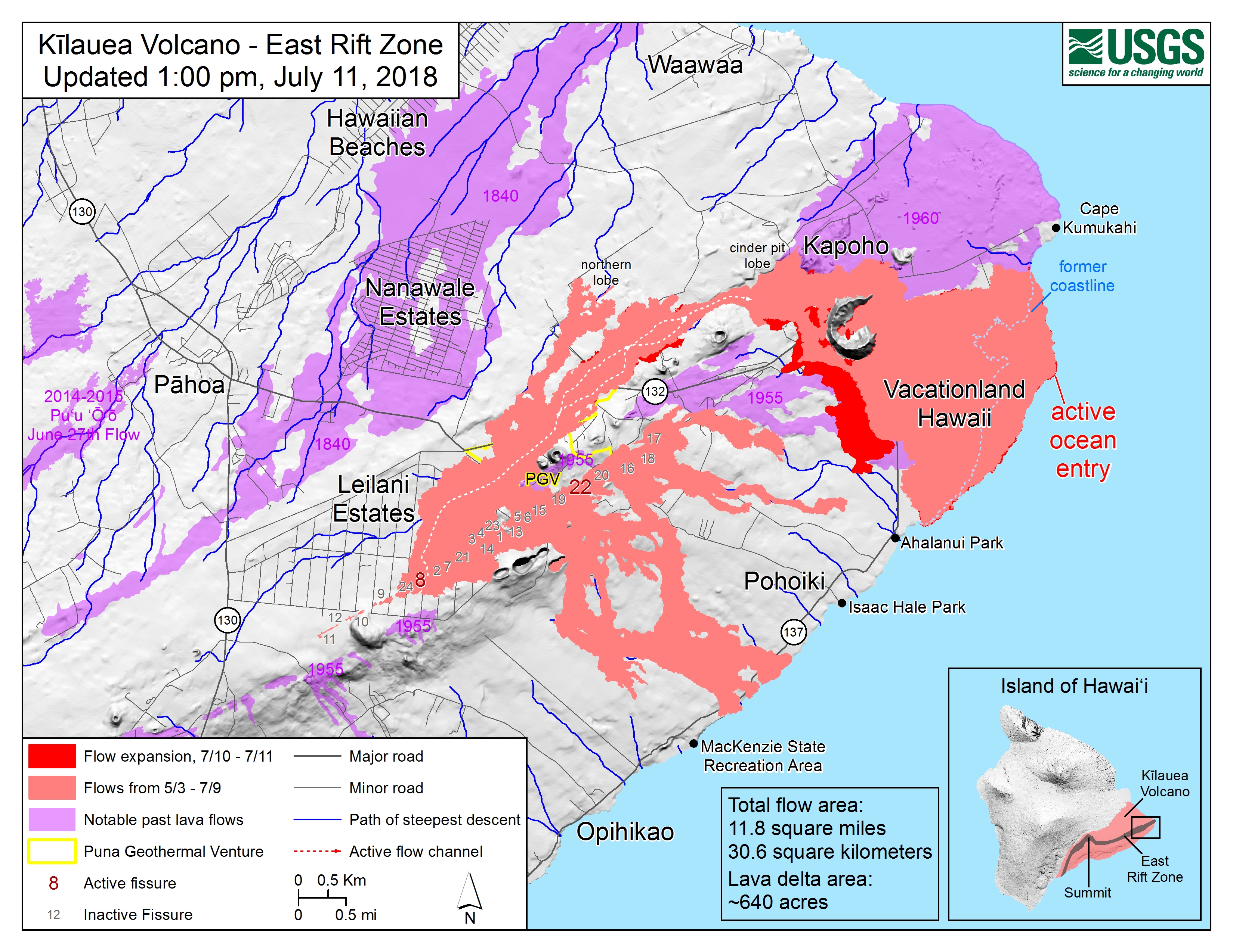
Wednesday, July 11, 2108, 4 p.m.: New Map, Aerial View of Kapoho
Map of the Lower East Rift Zone as of 1 p.m., July 11, 2018.
Map of the Lower East Rift Zone as of July 11, 2018. PC: USGS
Given the dynamic nature of Kīlauea’s lower East Rift Zone eruption, with changing vent locations, fissures starting and stopping, and varying rates of lava effusion, map details shown here are accurate as of the date/time noted. Shaded purple areas indicate lava flows erupted in 1840, 1955, 1960 and 2014-2015.
ARTICLE CONTINUES BELOW AD
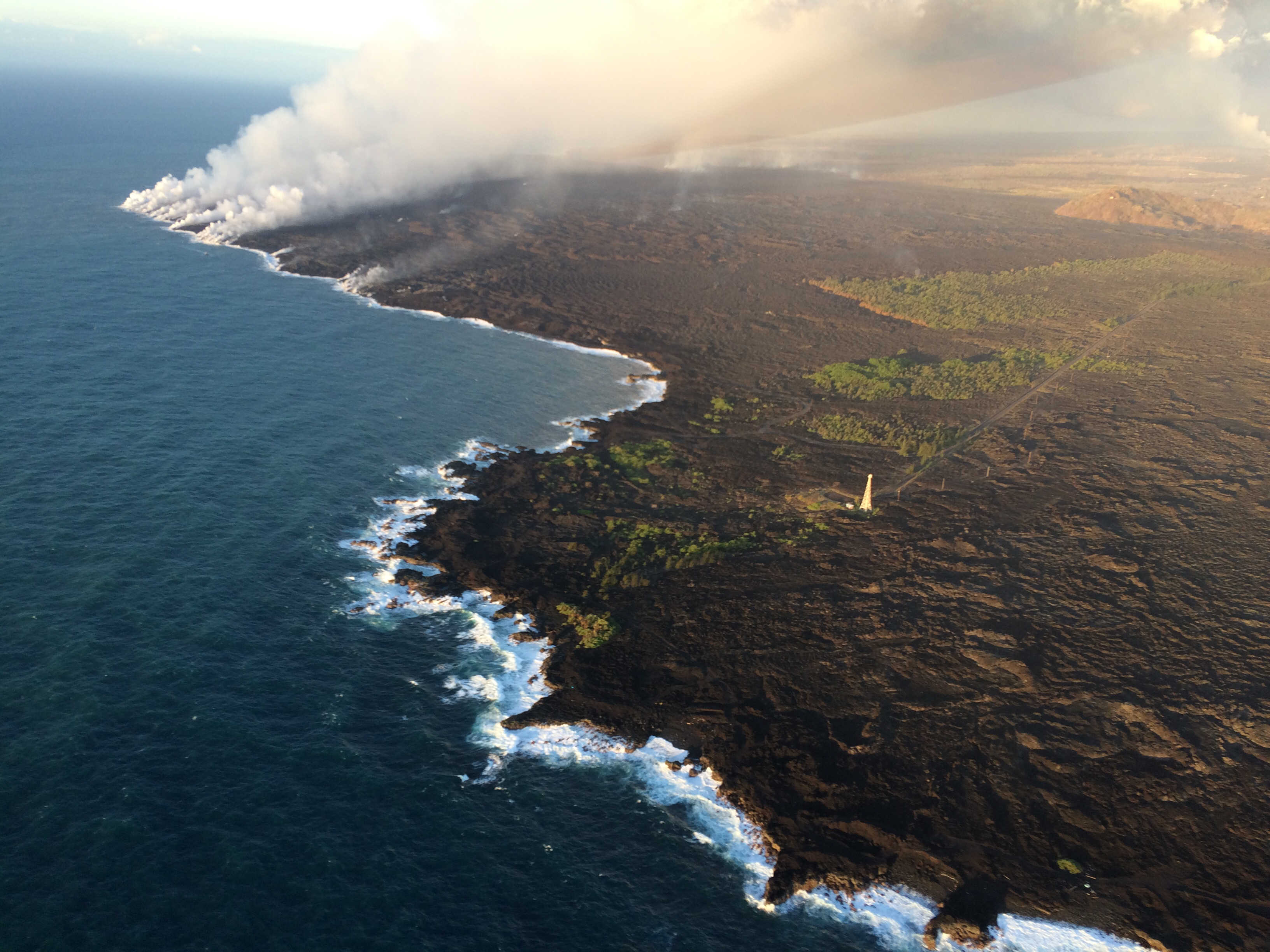
Aerial view of the ocean entry at Kapoho.
Aerial view of the ocean entry at Kapoho taken on July 11, 2018. Click to enlarge. PC: USGS
Cape Kumukahi (with lighthouse) is in the foreground, and Kapoho Crater is in the upper right.
At 5:46 a.m. on Wednesday, July 11, 2018, a collapse/explosion occurred beneath Kīlauea caldera with energy equivalent to a magnitude 5.3 earthquake. The number of earthquakes dropped from 30 to 40 per hour to less than 10 per hour. The USGS expects the earthquakes to increase over the next day until the next collapse/explosion tomorrow. Inward slumping of the rim and walls of Halemaʻumaʻu continues in response to the ongoing subsidence at the summit.
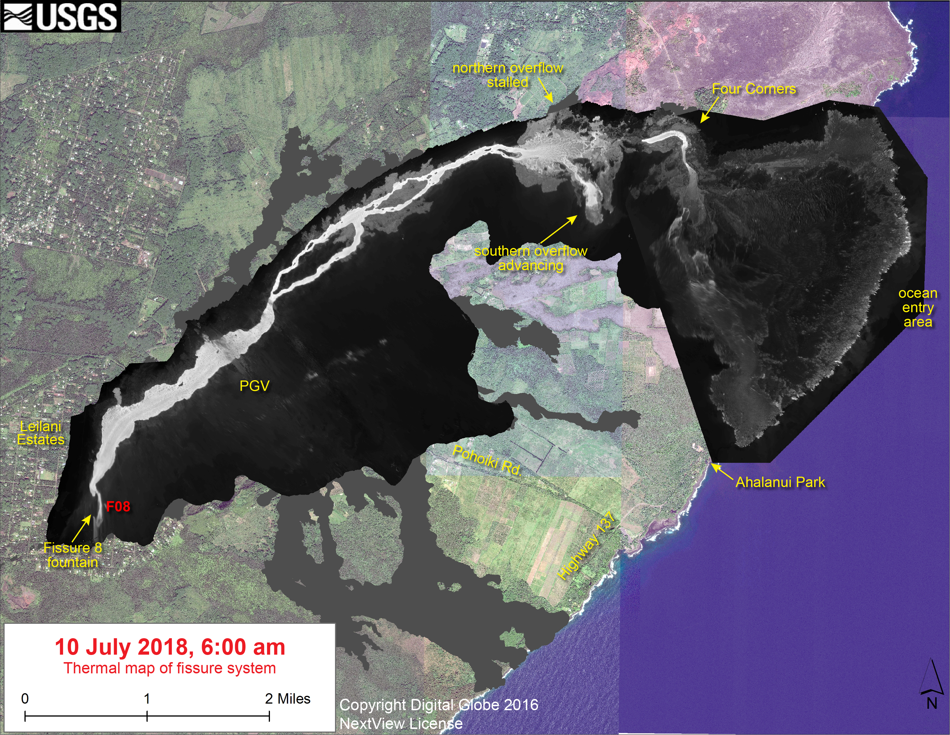
Wednesday, July 11, 2108, 1 p.m.: New Thermal Map, Flow Nears Ahalanui Park
This thermal map shows the fissure system and lava flows as of 6 a.m. on Tuesday, July 10, 2018.
Thermal map of the East Rift Zone on July 10, 2018. Click to enlarge. PC: USGS
ARTICLE CONTINUES BELOW AD
The fountain at Fissure 8 remains active, with the lava flow entering the ocean at Kapoho. Lava is overflowing the channel west of Four Corners, with the overflow headed south along the west side of Kapoho Crater. The black and white area is the extent of the thermal map. Temperature in the thermal image is displayed as gray-scale values, with the brightest pixels indicating the hottest areas. The thermal map was constructed by stitching many overlapping oblique thermal images collected by a handheld thermal camera during a helicopter overflight of the flow field. The base is a copyrighted color satellite image (used with permission) provided by Digital Globe.
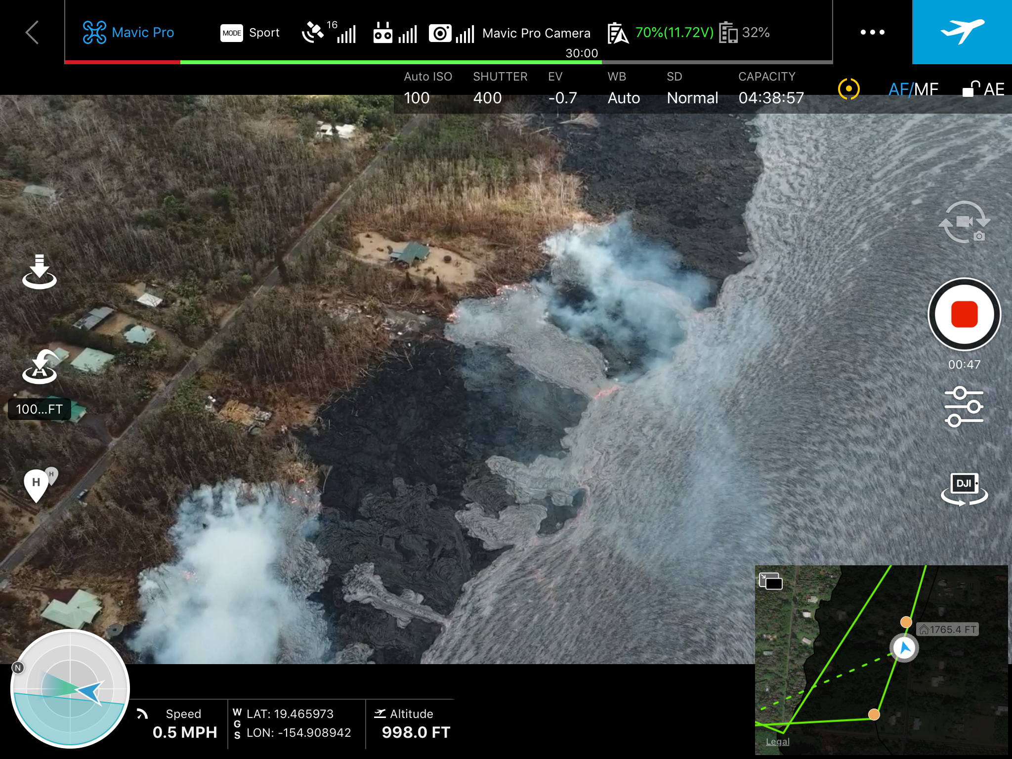
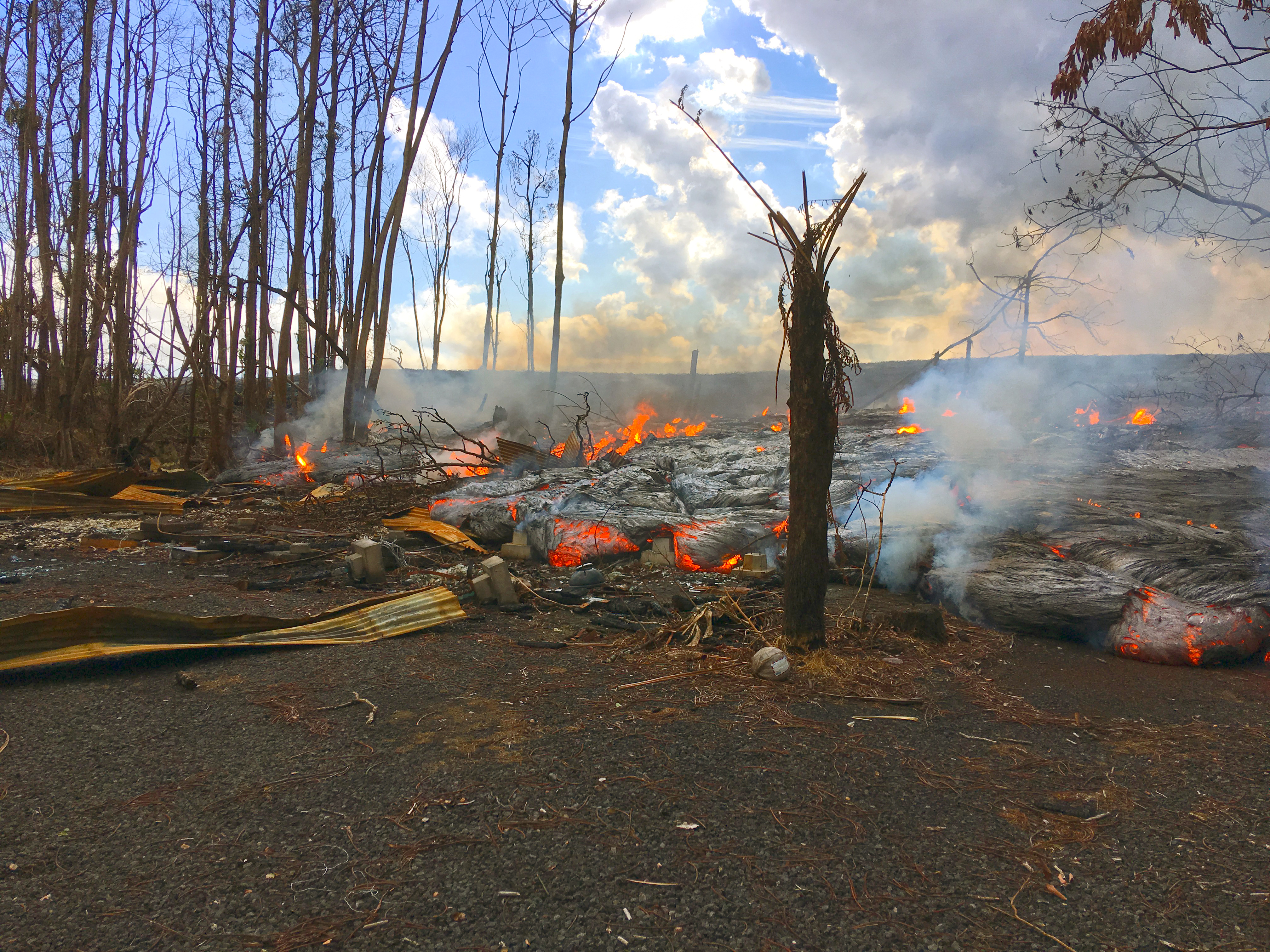
Fissure 8 continues to erupt lava into the perched channel leading northeastward from the vent. The upper channel between Fissure 8 and Pohoiki Rd. started overflowing about 8:30 or 9 a.m. with a few lobes advancing a short distance beyond previous flows threatening a few houses on Luana and Nohea Streets.
A screenshot of an aerial image captured by a MavicPro drone above the fissure 8 lava channel this morning. Overflows from the channel were threatening homes along Nohea and Luana Streets in the Leilani Estates subdivision. Click to enlarge. PC: USGS
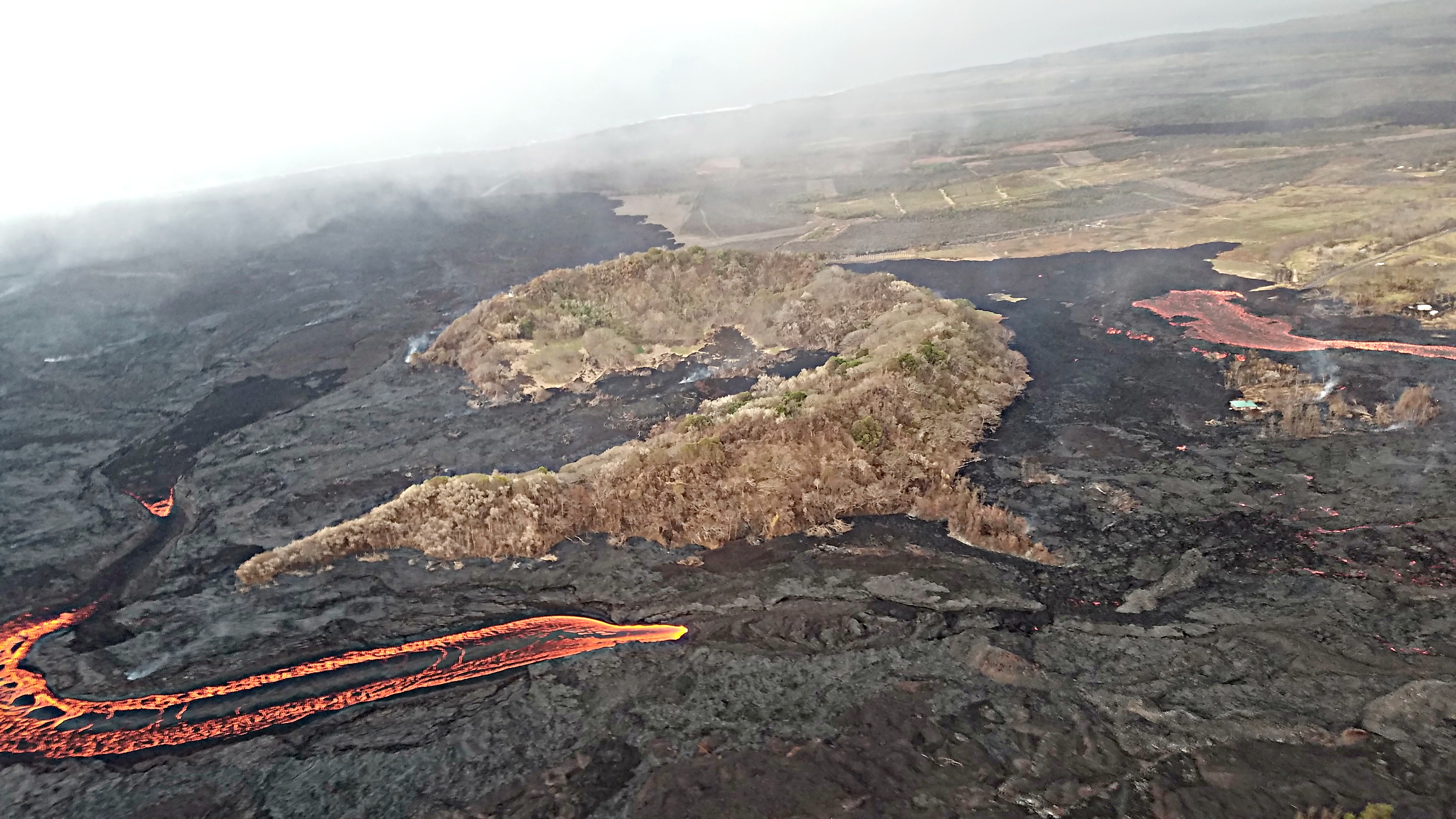
Last night and this morning, the channel was apparently blocked again just west of Kapoho Crater and a majority of channel lava began flowing south along the west edge of previous flows west of Kapoho Crater. By 10 a.m., this channelized ʻaʻā flow had advanced within 2,000 feet of the coast at Ahalanui Beach Park. The ocean entry continues to be active with more centralized building of a broad point into the ocean.
During an overflight this morning, the Hawai‘i County Fire Department captured this image looking east toward Kapoho Crater.
Photo of the East Rift Zone taken on July 11, 2018, by the Hawai‘i Fire Department. PC: USGS
A breakout from the south margin of the main Fissure 8 channel is sending a lava flow west of the crater (center, from left to right). The flow is advancing to the south toward Ahalanui (warm ponds).
Fissure 22 continues to exhibit weak spattering. No other fissures are active.
A pāhoehoe flow fed by overflows from the fissure 8 lava channel was active along Nohea Street in the Leilani Estates subdivision on July 11, 2018. Click to enlarge. PC: USGS
Pele’s hair and other lightweight volcanic glass fragments from the lava fountain at Fissure 8 continue to fall downwind of the fissure, dusting the ground within a few hundred yards of the vent.
A telephoto view of the eastern edge of Halema‘uma‘u taken just two minutes after the July 11, 5:45 a.m. collapse explosion event. Steam is intermixed with minor ash that imparts a pinkish-brown color to the plume. The energy released by the event was equivalent to a magnitude-5.3 earthquake. Click to enlarge. PC: USGS
High winds may waft lighter particles to greater distances. Residents are urged to minimize exposure to these volcanic particles, which can cause skin and eye irritation similar to volcanic ash.
Wednesday, July 11, 2108, Noon: Two More Homes Destroyed in Leilani Estates
Hawaiian Volcano Observatory reports that Fissure 8 continues to erupt lava into the perched channel heading northeast from the vent.
A flow moving around the west side of Kapoho Cone is .25 miles from the coast.
Breakouts are occurring from the main channel in Leilani Estates.
The United States Geological Survey has confirmed that two homes on Luana Street have been destroyed by the breakout, and one home on Nohea Street is threatened.
Be aware that spillovers of the channel and other breakouts are possible on the active flow field.
Do not access the active flow field due to extreme hazard.
6 a.m.: Lava Causes Brush Fires Near Kapoho Cone
Hawaiian Volcano Observatory reports that Fissure 8 continues to erupt lava into the perched channel heading northeast from the vent.
A lobe moving around the west side of Kapoho Cone remains active and small brushfires are reported along the edges.
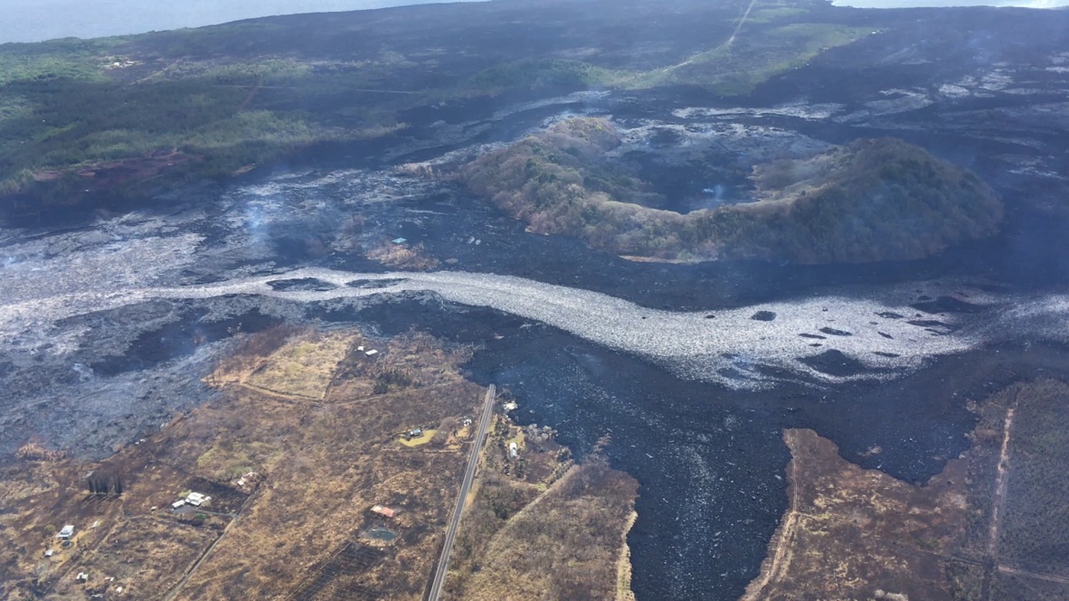
Aerial view of Kapoho Crater on July 10, 2018, looking south-southeast. Part of the lava channel became blocked just upstream of Kapoho Crater on July 9, diverting flows to the west and then south around the crater (center right). Lava exiting a crusted section of the channel continued flowing in the channel pathway (lower center to left). PC: USGS
Lava appears to be reoccupying the channel leading to the ocean entry where multiple fingers of lava are active.
Beginning this morning, USGS personnel will conduct helicopter overflights of the Volcano Village, Volcano Golf and Country Club, and National Park areas to map ground deformation. Flights will begin around 7 a.m. and continue throughout the morning.
The following policies remain in effect:
Be aware that spill overs of the channel and other breakouts are possible on the active flow field, do not access the active flow field due to extreme hazard.
The Disaster Recovery Center is open daily from 8 a.m. to 6 p.m. weekdays and 8 a.m. to 4 p.m. weekends. The center is located at the Kea‘au High School Gym. If you need a ride, buses run between the two shelters and the Disaster Recovery Center.
This comments section is a public community forum for the purpose of free expression. Although Big Island Now encourages respectful communication only, some content may be considered offensive. Please view at your own discretion. View Comments