News

New USGS Map, Photos and Video

Play
Listen to this Article
1 minute
Loading Audio... Article will play after ad...
Playing in :00
A
A
A

The U.S. Geological Survey released this map, photos and video of the East Rift Zone on Monday, June 18, 2018.

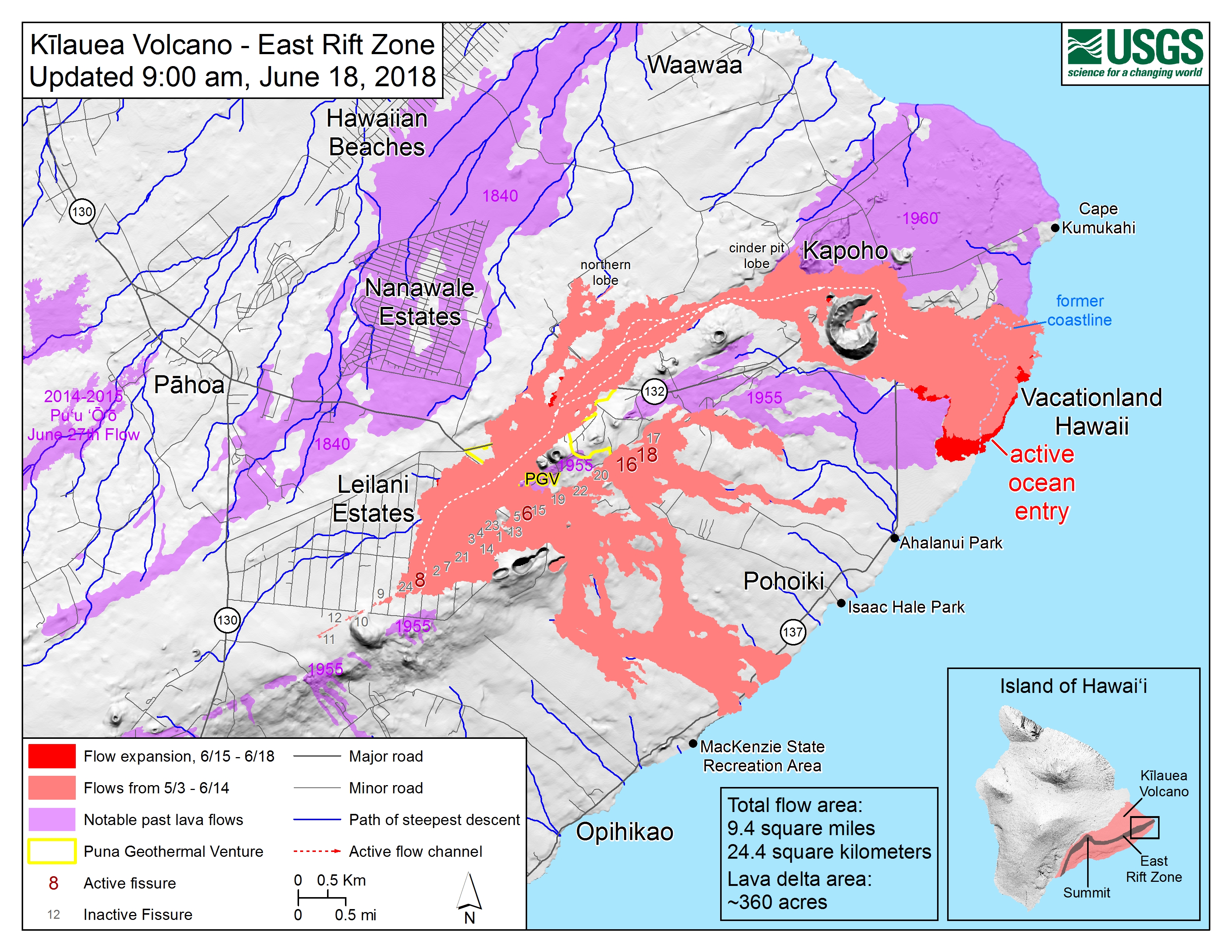
Map as of 9 a.m., June 18, 2018.

Click to enlarge

Given the dynamic nature of Kīlauea’s lower East Rift Zone eruption, with changing vent locations, fissures starting and stopping, and varying rates of lava effusion, map details shown here are accurate as of the date/time noted. Shaded purple areas indicate lava flows erupted in 1840, 1955, 1960, and 2014-2015.

googletag.cmd.push(function() { googletag.display(‘div-gpt-ad-1521147273013-1’); });

Kīlauea Volcano’s lower East Rift Zone

googletag.cmd.push(function() { googletag.display(‘div-gpt-ad-1521147273013-1’); });

Fissure 8 lava flows in an open channel all the way to the ocean. Kapoho Crater is the vegetated hill on the right side of the photograph.

Ocean entry plume seen in the distance. Click to enlarge.

Fissure 8 cone and channelized lava flow.

Click to enlarge

ARTICLE CONTINUES BELOW AD

ADVERTISEMENT

ad_queue.push(“14||28||49”);

ad_queue.push(“14||28||50”);

ARTICLE CONTINUES BELOW AD

ad_queue.push(“14||28||75”);

var mobile_text_ad_hide = function(){ if(jQuery(window).width() > 600) { jQuery(“.mobile_text_ads”).hide(); } }; jquery_queue.push(“mobile_text_ad_hide();”);

Fissure 6 (photo center) showed signs of activity overnight, producing small amounts of spatter and feeding short lava flows.

Fissure 6 is located about 1.4 miles downrift from Fissure 8. Click to enlarge.

ARTICLE CONTINUES BELOW AD

ADVERTISEMENT

ad_queue.push(“14||28||49”);

ad_queue.push(“14||28||50”);

ad_queue.push(“14||28||75”);

var mobile_text_ad_hide = function(){ if(jQuery(window).width() > 600) { jQuery(“.mobile_text_ads”).hide(); } }; jquery_queue.push(“mobile_text_ad_hide();”);

Seismic event generates weak plume captured by Halemaʻumaʻu webcam on June 18, 2018.

On June 18, 2018, at 6:13 a.m, a seismic event occurred at Halema‘uma‘u that produced a relatively ash-poor gas plume that rose about 1,600 feet above the crater. The activity was captured by the Halema‘uma‘u Wide Angle webcam located in the USGS–Hawaiian Volcano Observatory Observation Tower. The plume dissipated quickly.

Live Panorama of Lower East Rift Zone Camera from Lower East Rift Zone [PGcam]
Last Updated June 18, 2018, at 2:20 p.m.

Sponsored Content

Subscribe to our Newsletter

Stay in-the-know with daily or weekly
headlines delivered straight to your inbox.
Cancel
×

Comments

This comments section is a public community forum for the purpose of free expression. Although Big Island Now encourages respectful communication only, some content may be considered offensive. Please view at your own discretion. View Comments