This news story will be updated throughout the day as new information becomes available and new articles will be added to the website’s “News” section. Previous information about ongoing events can be found in Big Island Now’s “Volcano Blog” section.
Friday, May 26, 2018, at 7:46 p.m.: County of Hawai‘i
To protect yourself from breathing volcanic ash, free N95 masks will be distributed as follows:
Saturday, May 26, 2018, from 9 a.m. to 1 p.m. at all locations.
Pahala Gym Annex, Pahala
Na‘alehu Nutrition Center, Naalehu
Cooper Center, Volcano
Hawaiian Ocean View Community Center, HOVE
Shipman Gym, Kea‘au
Free masks will be made available to all families including those who picked up masks last week.
ARTICLE CONTINUES BELOW AD
ARTICLE CONTINUES BELOW AD
N95 masks do NOT protect against gases and vapors.
Mahalo 3M, Ohana Health Plan and HPM Building Supply for the donation of masks, Red Cross for distribution support and Community Emergency Response Teams.
Friday, May 26, 2018, at 6 p.m.: Civil Defense Update
The Hawaiian Volcano Observatory reports that eruption activity continues in the area of Leilani Estates and Lanipuna Gardens. Fissures 7 and 21 are feeding a lava pond, which produced a flow that has crossed Kahukai Street in Leilani Estates moving east.
Due to the active eruptions, the following policies are in effect:
Mohala Street is no longer accessible due to the flow that has crossed Kahukai Street.
Kaupili Street has not been cut off by the current flow. Residents should stay out of the area.
The Pāhoa Community Center, Kea‘au Community Center, and Sure Foundation Church are open. The shelters are pet-friendly.
ARTICLE CONTINUES BELOW AD
Friday, May 25, 2018, 4:55 p.m.: USGS Update
Fissure 22 continues to erupt lava that is flowing southeast to the coast where lava is entering the ocean. Fountains at Fissures 6 and 13 feed lava into a channel that also reaches the coast, making a second ocean entry.
Fissures 6 (left) and 13 (right), with lava flows merging into one channel that flows into the ocean at the western-most entry. Note plume in distance at the ocean entries (top left). Photo is from an overflight at mid day. Click to enlarge. (USGS Photo)
Fissure 7 and 21 are feeding a lava flow that has advanced northeastward crossing Kahukai St. at about 3:30 pm this afternoon and continuing to the northeast at a slow pace. Any residents remaining in the current affected areas should evacuate now.
Fissure 17 is barely active.
HVO field crews are on site tracking the lava flows and spattering from multiple fissures as conditions allow and reporting information to Hawai‘i County Civil Defense.
ARTICLE CONTINUES BELOW AD
Volcanic gas emissions have tripled as a result of the voluminous eruptions from the erupting fissures so SO2 concentrations are likely elevated to higher levels throughout the area downwind of the vents. Moderate trade winds today means that areas downwind of Kīlauea gas emission sources may experience varying levels of vog.
This eruption is still evolving and additional outbreaks of lava are possible. Ground deformation has slowed and seismicity levels have decreased in the area.
Future outbreaks could occur both uprift (southwest) and downrift (northeast) of the existing fissures, or, existing fissures can be reactivated. Communities downslope of the fissure system could be at risk from lava inundation. Activity can change rapidly.
Friday, May 25, 2018, 3 p.m.: Civil Defense Update
The Hawaiian Volcano Observatory reports that eruption activity continues in the area of Leilani Estates and Lanipuna Gardens.
Fissures 7 and 21 are feeding a perched lava pond and pāhoehoe flow heading east toward Kaupili, Mohala and Kahukai Streets in Leilani Estates.
Any residents remaining in the current affected areas should evacuate now.
Hawai‘i County Fire Department went door-to-door on Kaupili, Mohala and Kahukai Streets to check if residents needed assistance.
11 a.m.
The National Weather Service reports that trade winds will be slowing over the weekend, creating hazardous air quality and decreased visibility conditions throughout the lower East Rift Zone.
Volcanic gases, vog and ash emissions may increase over the weekend with higher levels of sulfur dioxide pooling in areas down wind of the vents.
Due to the changing conditions, the following policies are in effect:
Take action to limit further exposure and be prepared to leave the area with little to no notice if necessary.
Visibility may decrease. First responders are asking everyone be safe on the roadways and slow down.
Ash fallout may cause poor driving conditions. Drive with extreme caution, or pull over and park.
Stay alert for warnings from Civil Defense officials.
Free masks for ash protection will be distributed.
Distribution is from 3:30 to 7:30 p.m., and Saturday from 9 a.m. to 1 p.m.
Masks will be distributed at Ocean View Community Center, Na‘alehu Community Center, Pahala Community Center, Cooper Center and Shipman Gym in Kea‘au.
There are 1,400 masks available at each site. Each person may receive up to three masks.
Masks do not protect against gasses and vapors. They will only provide filtering for ash.
VIDEO UPDATE: May 24, 2018, 7:51 p.m.
Fissure 5 from a residence on Kahukai in Leilani Estates, taken with permission from the owner on May 24 at 7:51 p.m. The video was taken from the now dead end of Kahukai Street.
Friday, May 25, 2018, 6:30 a.m.
Hawaiian Volcano Observatory reports that lava flows continue on the east rift of Kilauea.
Active flows continue in Leilani Estates and entering the ocean near Makenzie State Park.
Due to the volcanic activity, the following is provided for your awareness:
Eruption activity could change at any moment you are asked to maintain situational awareness and be prepared to respond to changing conditions.
This includes your family and business emergency plans to include communications if you need to evacuate.
An information center is operating Monday through Friday at the Pāhoa Community Center from 9 a.m. to 3 p.m.
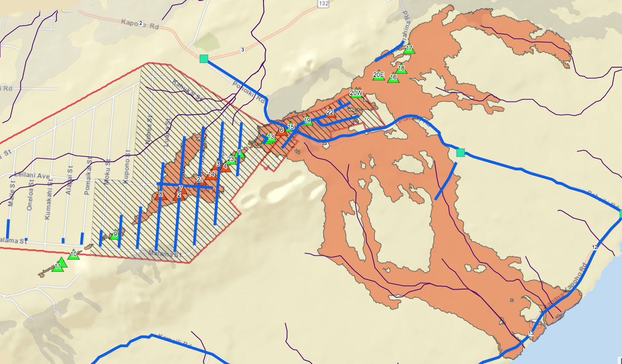
Map as of May 25, 2018, 7 a.m. MC: Hawai‘i County
HAWAIIAN VOLCANO OBSERVATORY STATUS REPORT
Thursday, May 24, 11:04 p.m.
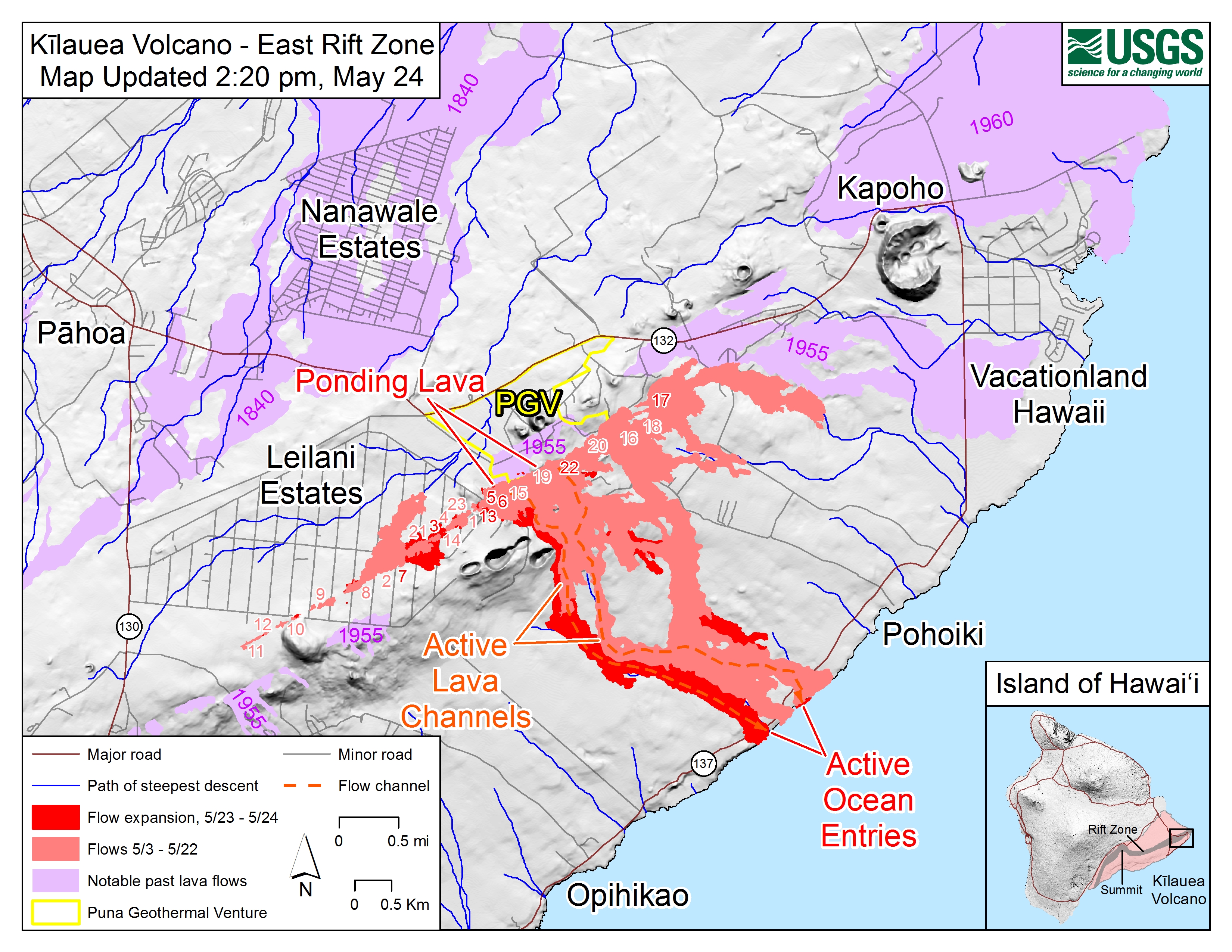
Kīlauea Volcano Lower East Rift Zone
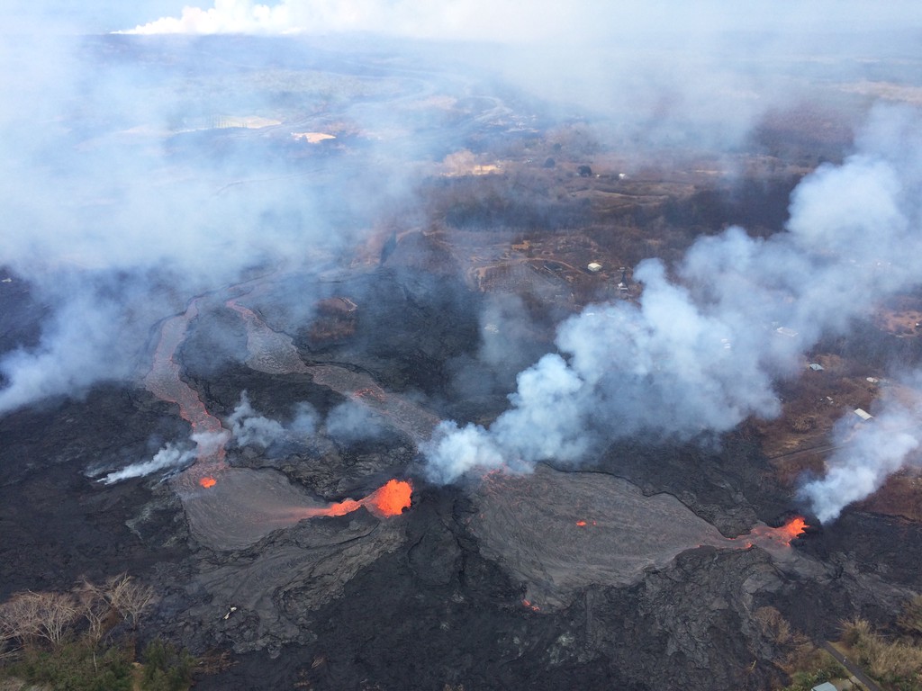
Eruption of lava continues in the area of Leilani Estates and Lanipuna Gardens.
Fissure 22 continues to erupt lava that is flowing southeast to the coast and the lava ocean entry.
Fountains at Fissures 6 and 13 feed lava into a channel that reached the coast yesterday, forming a second ocean entry.
Fissures 7 and 21 are feeding a perched lava pond and pāhoehoe flow that has advanced eastward covering most of the area bounded by Leilani Boulevard, Mohala Street and the fissure line.
Fissure 17 continues weak spattering, while Fissures 19 and 23 are no longer active.
HVO field crews are on site tracking the fountains, lava flows and spattering from multiple fissures as conditions allow and reporting information to Hawai‘i County Civil Defense.
Volcanic gas emissions remain very high from the fissure eruptions.
Magma continues to be supplied to the lower East Rift Zone. Earthquake activity continues, but earthquake locations have not moved farther downrift in the past few days and the number of located earthquakes remains low.
Additional ground cracking and outbreaks of lava in the area of the active fissures are possible. Residents downslope of the region of fissures should heed all Hawai‘i County Civil Defense messages and warnings.
USGS/HVO continues to monitor the lower East Rift Zone activity 24/7 in coordination with Hawaii County Civil Defense.
Kīlauea Volcano Summit
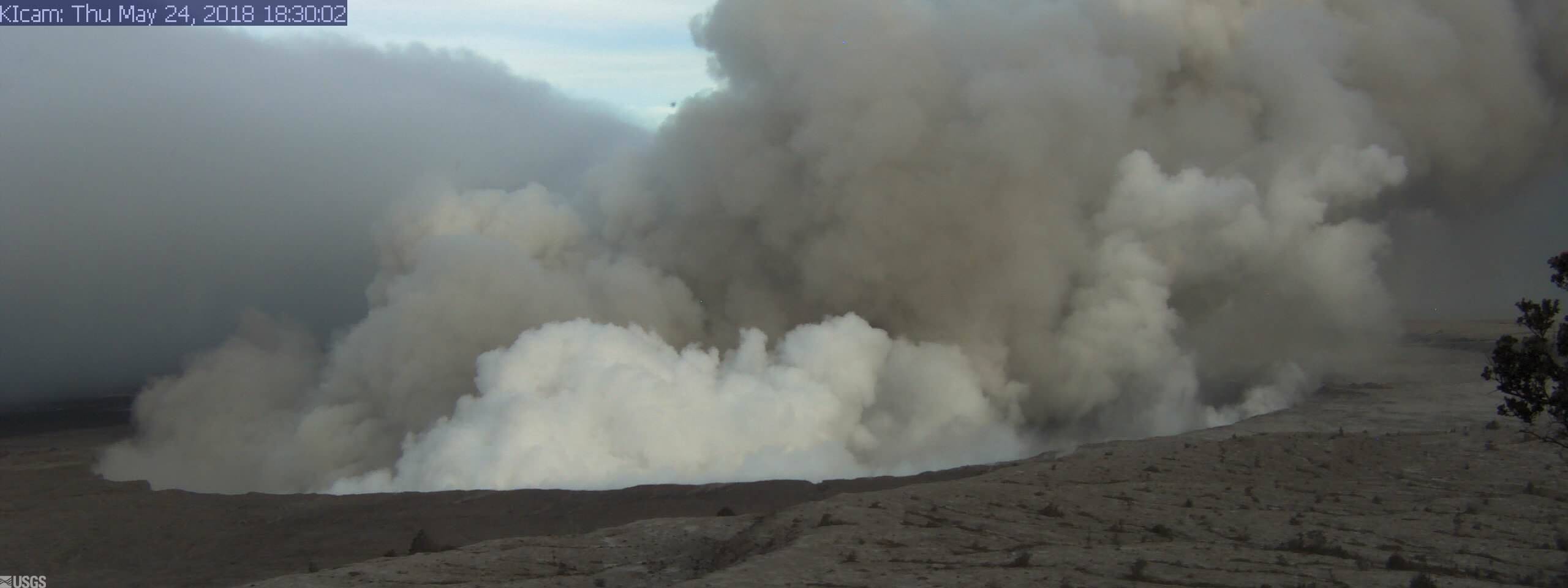
From HVO Observation Tower, May 24, 2018, at 6:30 p.m.
An explosion was detected from the summit Overlook Crater just after 6 p.m. that produced an ash cloud that rose to 10,000 feet above sea level and carried slightly more ash than most recent explosions. The National Weather Service Nexrad radar tracked the cloud for 15 to 20 minutes. Moderate trade winds were blowing to the southwest and light ash fall likely occurred in downwind locations.
Summit explosion, May 24 at 6:30 p.m. PC: Pamela Mizuno
Earthquakes in the summit area continue at a moderate rate, as does deflation of the summit region. The earthquakes and ash explosions are occurring as the summit area subsides and adjusts to the withdrawal of magma from the summit.
Additional explosive events that could produce minor amounts of ashfall downwind are possible at any time. Volcanic gas emissions at the summit remain high.
For forecasts of where ash would fall if such an explosion occur, please consult the Ash3D model output here.
Information on ash hazards and how to prepare for ashfall maybe found here.
HVO OVERVIEW OF THE LAST WEEK
On Kīlauea Volcano’s East Rift Zone, low-level eruption of lava continues from multiple points along the active fissure system.
At Kῑlauea’s summit, multiple explosions continue to occur daily, with some sending plumes of ash up to 8,000 feet above sea level or higher. With prevailing trade winds this past week, the ash clouds were largely blown to the southwest, resulting in trace amounts of ash falling on downwind areas.
Summit activity could again become more explosive, increasing the intensity of ash production and producing ballistic projectiles close to the vent. Communities downwind should be prepared for ashfall as long as this activity continues.
Mauna Loa is not erupting. Rates of deformation and seismicity have not changed significantly over the past week.
The number of monthly and weekly earthquakes recorded beneath the volcano has decreased to near background levels.
Eleven earthquakes were reported felt in Hawai‘i during the past week. Many were related to continued deflation at Kīlauea’s summit and with the ongoing intrusion of magma into the volcano’s East Rift Zone.
The largest was a magnitude-5 earthquake on May 16, at 6:15 p.m. located 3 miles southwest of Volcano Village and at a shallow depth.
This comments section is a public community forum for the purpose of free expression. Although Big Island Now encourages respectful communication only, some content may be considered offensive. Please view at your own discretion. View Comments