High Surf Advisory Posted, Larger Swell Ahead
Alerts (as of 1:00 a.m.)
High Surf Advisory: North shores of Big Island through 6 p.m. Monday.
Small Craft Advisory: Until 6 p.m. Monday for 10 to 20 knots with higher gusts.
Marine Weather Statement: The current north swell has peaked overnight and is trending down Monday. This swell could still produce moderate surges in all north facing harbors like Hilo Harbor. Large breaking waves near channel and harbor entrances mean mariners need to exercise caution when entering or leaving port and when mooring or launching vessels.
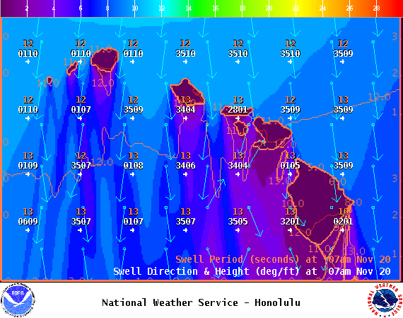
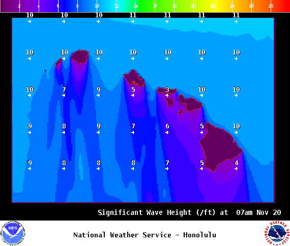
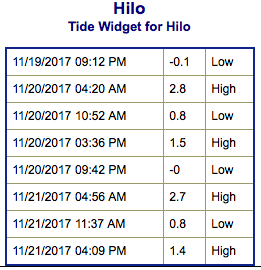
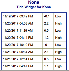
**Click directly on the images below to make them larger. Charts include: Big Island projected winds, tides, swell direction & period and expected wave heights.**
Big Island Surf Forecast
Hilo: Wave heights are expected to be overhead to double overhead today.
Kona: Wave heights are expected to be waist high or less today.
South: Wave heights are expected to be waist high or less today.
Our current northerly swell has peaked overnight and is forecast to hold through Monday and slowly begin easing. Overlapping swells are forecast over the next week. The next swell is forecast to be a few feet larger than the current fading one and arrive Wednesday. This swell is likely going to be at warning feels for north facing shores of all exposed islands.
Small southerly swells will continue with small background swell for south facing shores.
Keep in mind, surf heights are measured on the face of the wave from trough to crest. Heights vary from beach to beach, and at the same beach, from break to break.
**Click here for your detailed Big Island weather report.**


