Hurricane Fernanda, Tropical Depression Seven-E and another tropical disturbance in the Eastern Pacific as of 1230 p.m. July 17, 2017.
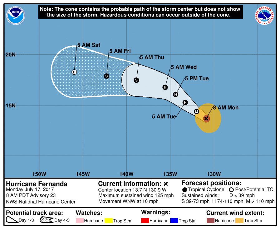
Hurricane Fernanda location and probability cone as of 8 a.m., July 17, 2017. The Big Island is located at 155 W degrees. NOAA/NWS/NHC
The National Weather Service reported that Hurricane Fernanda Hurricane Fernanda was centered about 1,434 ESE of Hilo at 3 a.m., Sunday, July 16, moving WNW at 10 mph.
Maximum sustained winds are 125 mph with gusts to 155 mph, qualifying Fernanda as a Category 3 hurricane on the Saffir-Simpson Hurricane Wind Scale.
At this time, Hurricane Fernanda is weakening as forecasted and is expected to continue this weakening trend.
ARTICLE CONTINUES BELOW AD
ARTICLE CONTINUES BELOW AD
Steady weakening is expected over the next 48 hours.
Large swells will continue to expand and spread out ahead of Fernanda to the NW and W during the next few days, and are expected to reach the Hawaiian Islands early Wednesday.
It is too early to know what effects, if any, Hurricane Fernanda will have on our island or state.
ARTICLE CONTINUES BELOW AD
The next update is scheduled for Wednesday, July 19.
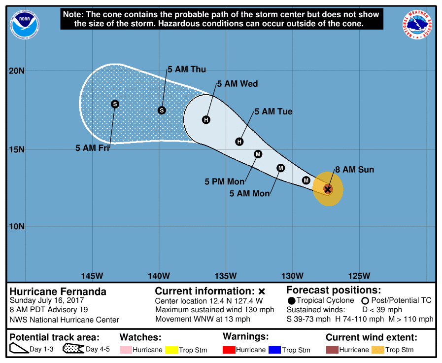
Hurricane Fernanda in the Eastern Pacific was downgraded to a Category 3 storm on Saturday, July 15, 2017, and is forecast to weaken to a tropical storm later in the week as it enters the Central Pacific,according to the National Hurricane Center in Miami.
At 5 p.m. Saturday night, Fernanda was 2,046 miles southeast of Hilo with maximum sustained winds of 125 mph and moving west-northwest at 14 mph.
ARTICLE CONTINUES BELOW AD
While the wind speed weakened throughout Saturday, forecasters said Fernanda could regain some strength today before weakening steadily as it moves over cooler waters and encounters wind shear.
Fernanda is forecast to enter the Central Pacific on Thursday, July 20, it is expected to be downgraded to a tropical storm with maximum sustained winds of 45 mph.
As seen in the probability cone cone map above, Fernanda is predicted to reach 145 degrees W longitude on Friday; the Big Island is located at approximately 155 degrees W longitude.
However, it is still uncertain how Fernanda may impact the State of Hawai‘i.
This comments section is a public community forum for the purpose of free expression. Although Big Island Now encourages respectful communication only, some content may be considered offensive. Please view at your own discretion. View Comments


 Hurricane Fernanda in the Eastern Pacific was downgraded to a Category 3 storm on Saturday, July 15, 2017, and is forecast to weaken to a tropical storm later in the week as it enters the Central Pacific,according to the National Hurricane Center in Miami.


