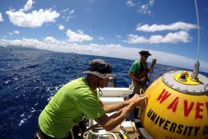
Pacific Islands Ocean Observing System (PacIOOS) wave buoy in waters off Pearl Harbor, Oahu. Photo credit: PacIOOS/K. Millikan.
Pacific Islands Ocean Observing System (PacIOOS) staff prepare to deploy the wave buoy off Pearl Harbor. Photo credit: PacIOOS/K. Millikan.
The Pacific Islands Ocean Observing System (PacIOOS) deployed a new wave buoy on June 6 near the entrance to Pearl Harbor approximately 1.5 miles offshore.
The wave buoy provides accurate information on wave height, direction and period and also measures surface currents and sea surface temperature.
Wave buoy data benefit the entire community and are important to make well-informed and safe decisions. Real-time wave information improves surf and ocean observations, and enhances wave modeling and surf forecasting. All wave buoy data are available online free of charge.
ARTICLE CONTINUES BELOW AD
ARTICLE CONTINUES BELOW AD
“County, state and federal agencies, such as the U.S. Coast Guard, U.S. Navy and NOAA’s National Weather Service, incorporate wave buoy data into their daily operational decision-making processes,” saidMelissa Iwamoto, director of PacIOOS. “Many commercial and recreational ocean users, community members and researchers also rely on the data. We are therefore extremely excited to offer a new observing asset to augment the existing network and better serve our community of users.”
The wave buoy off Pearl Harbor is the first PacIOOS wave buoy with the capability to measure surface currents at 10-minute intervals. Currents data, along with wave information, will help to enhance marine safety, navigation and harbor operations on O‘ahu’s South Shore, in particular in the waters around Pearl Harbor.
The location of the buoy has been issued as a Notice to Mariners and will be included on nautical charts; however, the buoy is constantly in motion and can drift from its charted position. To keep the buoy and its sensors operational, vessel operators and other ocean users are asked to maintain a stand-off distance of at least 300 feet to avoid collisions and damage to the buoy. Boaters, kayakers and stand-up paddlers are asked to refrain from tying to the equipment and to avoid fishing near the buoy.
ARTICLE CONTINUES BELOW AD
The Hawaiʻi Natural Energy Institute at the University of Hawaiʻi at Mānoa provided the initial support to purchase the buoy with funding from the Office of Naval Research. The buoy joins a network of 15 real-time wave buoys across the Pacific Islands, owned and operated by PacIOOS. Data management for the PacIOOS wave buoys is made possible through long-term partnerships with the U.S. Army Corps of Engineers and the Coastal Data Information Program.
This comments section is a public community forum for the purpose of free expression. Although Big Island Now encourages respectful communication only, some content may be considered offensive. Please view at your own discretion. View Comments