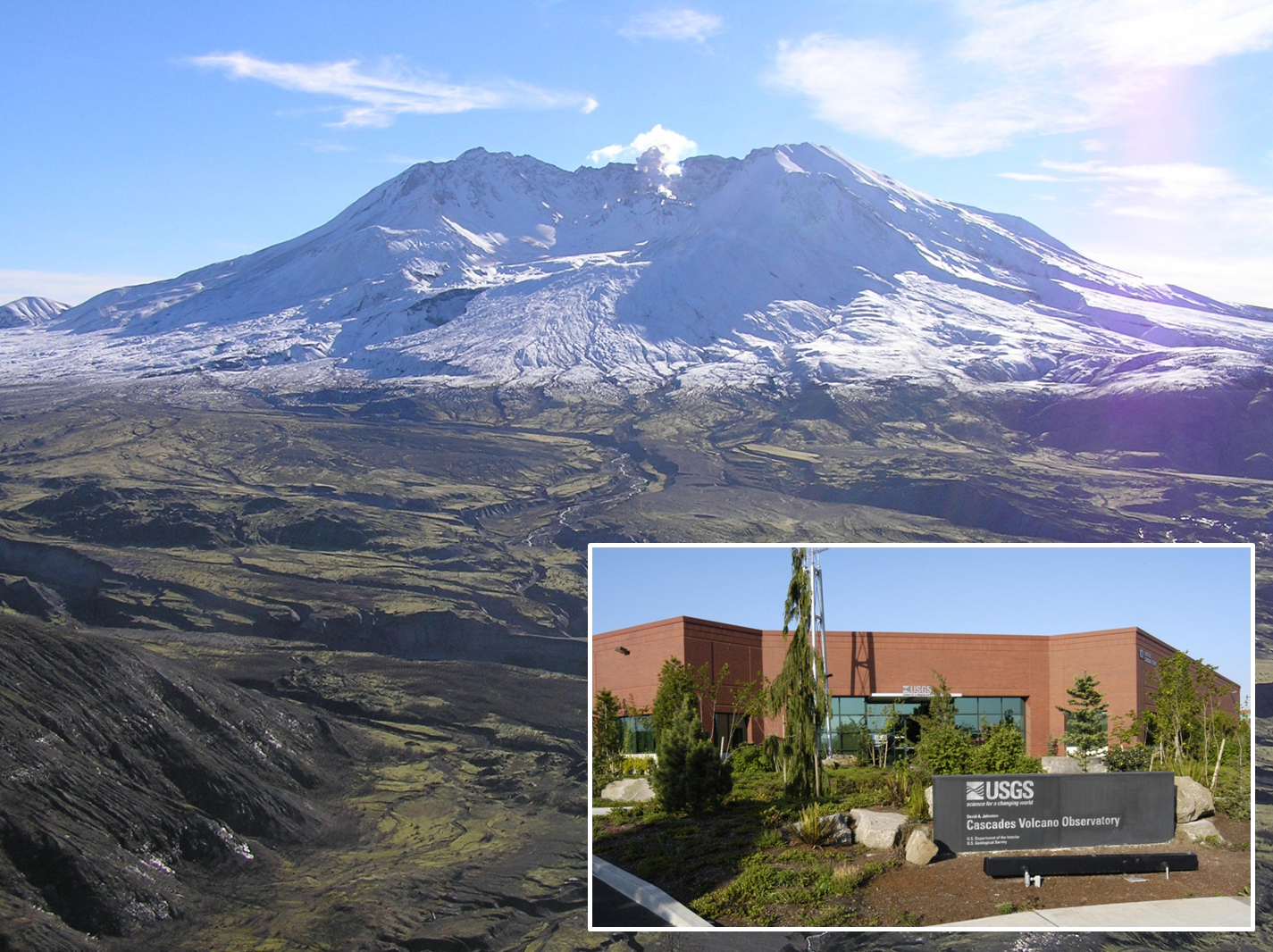
Mount St. Helens in December 2004, a few months after the start of the volcano’s most recent eruption, as seen from the Johnston Ridge Observatory in Mount St. Helens National Volcanic Monument in Washington. Inset: The USGS Cascades Volcano Observatory in Vancouver, WA, monitors volcanoes in Washington, Oregon, and Idaho. USGS photos.
How well do you know USGS volcano observatories?
Part 1: Cascades
It’s January 2017, and in addition to wishing you Hauʻoli Makahiki Hou (Happy New Year), the USGS Hawaiian Volcano Observatory (HVO) welcomes you to the 8th Annual Volcano Awareness Month on the Island of Hawaiʻi! Throughout the month, HVO, in cooperation with Hawaiʻi Volcanoes National Park and the University of Hawaiʻi, will offer public talks around the island. For the complete schedule, visit HVO’s website.
As in years past, our “Volcano Watch” articles this month will explore a volcanic theme.
Most readers are familiar with HVO—the first volcano observatory in the United States, and one of the oldest such facilities in the world. But how well do you know the other four U.S. Geological Survey (USGS) volcano observatories, and how work in Hawaiʻi has influenced each?
ARTICLE CONTINUES BELOW AD
ARTICLE CONTINUES BELOW AD
We start our exploration with the second oldest USGS observatory—the David A. Johnston Cascades Volcano Observatory (CVO) in Vancouver, Washington.
CVO was founded after the devastating May 18, 1980, eruption of Mount St. Helens, during which the observatory’s namesake lost his life while monitoring the activity. During the two-month buildup to that eruption, a steady stream of volcanologists set up camp in Vancouver, collocated with U.S. Forest Service headquarters. Many of these scientists were current or past HVO staff, since Hawaiʻi is an ideal place for USGS scientists to gain familiarity with studying and monitoring active volcanoes.
Following the catastrophic 1980 eruption, several smaller explosions and lava extrusions occurred at Mount St. Helens, which demanded continuous observation to better understand how the volcano worked and to provide warnings of volcanic hazards. Most of the monitoring techniques used there had been pioneered in Hawaiʻi; for example, laser ranging and tilt to assess deformation, and strategies to sample gas emissions.
The acknowledgment that Mount St. Helens is just one of over a dozen large volcanoes in the Cascade Range of Washington, Oregon and California led to CVO’s permanent establishment in 1982. The observatory rapidly built basic monitoring networks on all the volcanoes for which it is responsible.
After Mount St. Helens went quiet in 1986, CVO focused attention on other Cascade volcanoes and volcanic processes. Scientists designed experiments to understand volcanic landslides, studied how sediment from a volcano can influence river systems, and mapped each of the volcanoes to better understand their past activity.
ARTICLE CONTINUES BELOW AD
Working groups were formed for each Cascade volcano to develop volcano response and coordination plans, which are critical tools for ensuring smooth communications and effective responses during a volcano crisis. The Volcano Disaster Assistance Program, a collaborative effort of the USGS and the U.S. Agency for International Development’s Office of U.S. Foreign Disaster Assistance that is headquartered at CVO, also quickly grew into a world-renowned team of experts that responds to volcanic crises around the world at the request of foreign governments.
CVO’s preparation and vigilance paid off when Mount St. Helens rumbled back to life in September 2004, beginning a period of lava dome growth with occasional small explosions that lasted until early 2008. The eruption was a great opportunity for scientists to further develop new technologies to study the eruption, including remote cameras (based on an HVO design), as well as robotic “spiders” that hosted multi-parameter instrument packages and could be deployed by helicopter.
After 2008, CVO embarked on a mission to upgrade monitoring at all Cascade volcanoes, including better seismic networks, continuous GPS stations, gas monitoring sensors, and other instruments. In 2004, there were only four continuous GPS stations dedicated to volcano monitoring in the Cascades—one at Mount St. Helens and three at South Sister, Oregon. Today, there are several dozen GPS stations spread across the Range.
CVO’s work is not done, however. Some Cascade volcanoes still have relatively few monitoring instruments. Educating local populations about volcanic hazards—especially if the “volcano in their backyard” hasn’t erupted in several hundred years—also remains a priority. In these efforts, CVO and HVO work together, exchanging staff to facilitate the sharing of ideas and best practices.
Next week, we’ll visit the observatory that tracks volcanoes in the Last Frontier—Alaska! Until then, please join us for this coming week’s Volcano Awareness Month talks at Hawaiʻi Volcanoes National Park on Jan. 10 and Hilo’s Lyman Museum on Jan. 12.
ARTICLE CONTINUES BELOW AD
Volcano Activity Updates
Kīlauea continues to erupt at its summit and East Rift Zone. This past week, the summit lava lake level varied between about 30 and 112 feet below the vent rim. The 61g lava flow was still active and entering the ocean near Kamokuna. On Dec. 31, nearly all the eastern Kamokuna lava delta collapsed into the ocean, along with a large section of the older sea cliff east of the delta.
Significant hazards are associated with ocean entries and delta collapses, so visitors to the coastal lava viewing area are cautioned to heed all warning signs and to stay outside closed areas.
A younger branch of the 61g flow is advancing slowly to the east of Pu‘u ‘Ō‘ō, but none of the 61g flows pose an immediate threat to nearby communities.
Mauna Loa is not erupting. During the past week, only a few small-magnitude earthquakes occurred beneath the volcano, primarily in the upper Southwest Rift Zone and summit caldera at depths less than 3 miles. GPS measurements continue to show deformation related to inflation of a magma reservoir beneath the summit and upper Southwest Rift Zone.
One earthquake was reported felt on the Island of Hawaiʻi during the past week. On Jan. 4, at 11:02 p.m., HST, a magnitude-2.8 earthquake occurred 11.3 miles northwest of Kailua Kona at a depth of 6.2 miles.
Volcano Watch is a weekly article and activity update written by U.S. Geological Survey Hawaiian Volcano Observatory scientists and affiliates.
Call for summary updates at (808) 967-8862 (Kīlauea) or (808) 967-8866 (Mauna Loa); email questions to [email protected].
This comments section is a public community forum for the purpose of free expression. Although Big Island Now encourages respectful communication only, some content may be considered offensive. Please view at your own discretion. View Comments