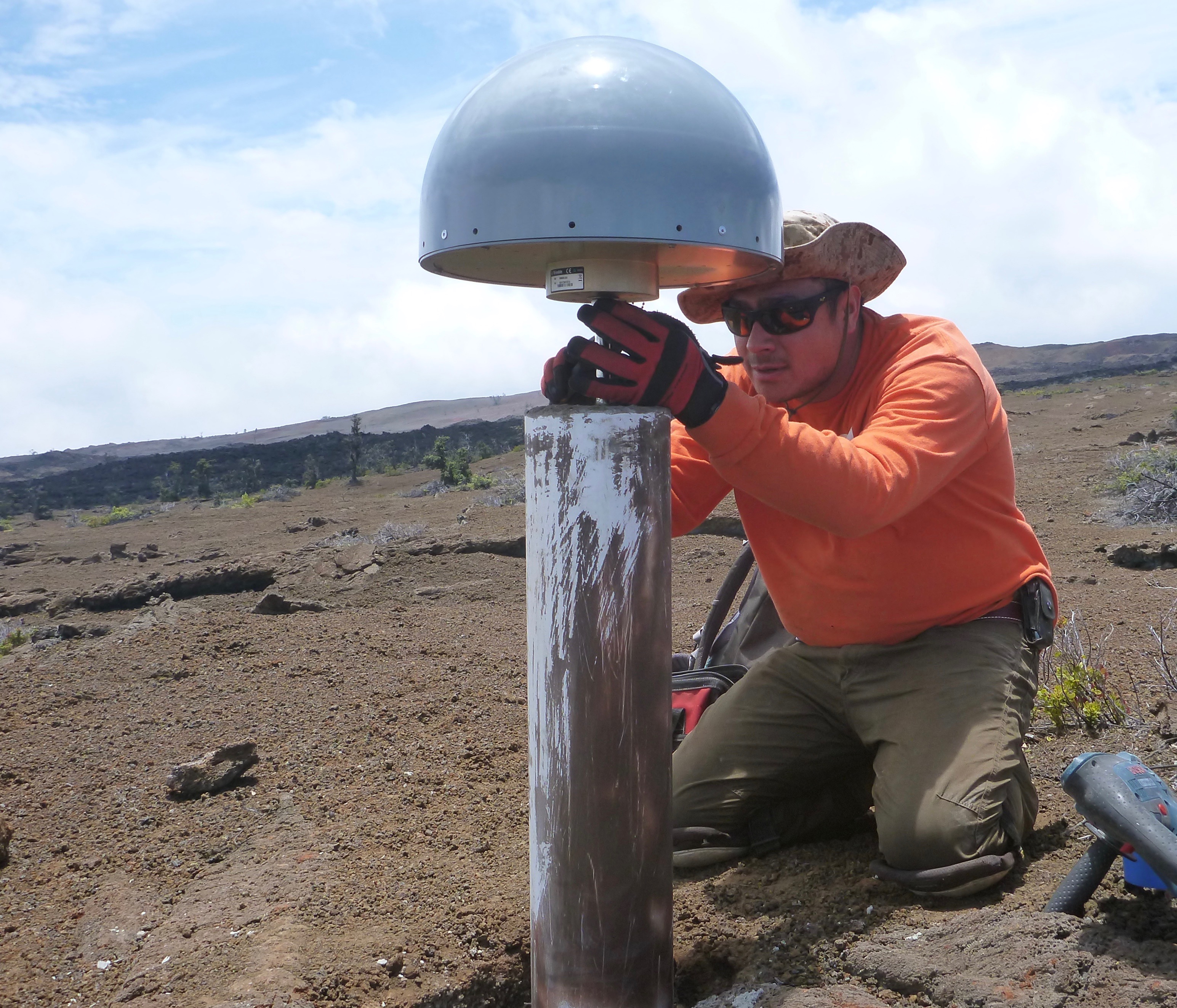
A USGS Hawaiian Volcano Observatory scientist puts the finishing touches on a new permanent GPS station on the slopes on Mauna Loa. The GPS antenna, protected from the elements by the grey radome, is solidly attached to the ground via a cement-reinforced steel rod. GPS is a critical tool for tracking ground motion on Hawaiian volcanoes. USGS photo.
Using the Global Positioning System (GPS) in your cell phone or car has become an everyday occurrence that many of us take for granted and now consider indispensable.
GPS-enabled gadgets are, in fact, everywhere: watches, cameras, luggage and dog tags can all tell us exactly where on the planet they are.
Hawaiʻi is also “GPS-enabled” and GPS is truly indispensable for understanding our dynamic island. This is accomplished through a network of over 60 scientific-grade GPS stations operated by scientists at the USGS Hawaiian Volcano Observatory. It is one of the primary tools we use to monitor ground motion and detect what’s happening inside and around Hawaiian volcanoes.
As magma (molten rock) accumulates in a volcano’s underground plumbing system, it increases the pressure in the magma reservoir, or storage chamber, which pushes the ground outward. When magma leaves the storage chamber (to erupt, for example), the ground is drawn back inward.
By measuring the motion of GPS instruments toward and away from the magma reservoir, we can estimate how much magma is moving in and out of the system. With a dense network of sensors and continuous data, we can also detect changes that might indicate magma movement toward the surface.
ARTICLE CONTINUES BELOW AD
ARTICLE CONTINUES BELOW AD
GPS data are also crucial for measuring other phenomena on the volcano. For example, GPS data are used to monitor the movement of Kīlauea’s south flank toward the ocean, a process that creates stresses that can lead to earthquakes. Large earthquakes also produce permanent ground displacements that can be measured with scientific-grade GPS.
The instrumentation in a scientific GPS station utilizes the same signals as a cell phone or car navigation system. However, there are two key differences. First, we don’t move scientific GPS instruments around. Instead, our GPS antennas are tightly fixed to the ground, because what we want to measure is the motion of the ground itself.
The second difference is in how we analyze signals from GPS satellites. Our continuously recording instruments send data via wireless links to HVO, where we use a method called “carrier-phase tracking” to calculate positions far more accurate than a hand-held device can provide. Crunching an entire day’s worth of GPS signals collected in this way can yield positions precise to several millimeters (1/8 inch). This means we can track very small and slow changes in the shape of the ground.
Scientific GPS also provides accurate measurements of large, fast motions, like those that occur before and during an eruption or intrusion. For example, during the buildup to Kīlauea’s 2007 Father’s Day eruption, a nearby GPS station recorded nearly 2.3 feet of movement within two days. Even larger and faster motions are possible when bigger volumes of magma are involved.
Recent developments in data processing techniques have extended the use of scientific GPS data to provide second-by-second updates in ground position and to calculate these in “real-time,” or within seconds of data collection. This will further improve our ability to quickly detect and measure large, fast motions.
ARTICLE CONTINUES BELOW AD
This may not sound impressive, given that cell phones provide nearly instantaneous position updates as we drive down the road. However, the key difference is in the precision of the positions that HVO is able to obtain.
While “real-time” GPS has lower accuracy than GPS positions calculated over an entire day, we can now reliably detect motions of about 2 inches, and improvements are in progress to increase this accuracy. This is equivalent to accurately tracking the position of your cell phone as you pass it from one hand to the other.
Monitoring the changing shape of Hawaiʻi’s active volcanoes provides valuable information about the movement of magma. In the days, hours, and minutes leading up to an eruption, the speed at which we determine where magma might be headed becomes critical. The more accurately and quickly we can get this information, the faster we can provide guidance to emergency managers and the public about possible eruption locations and impacts.
With this in mind, HVO continually strives to improve the accuracy and timeliness of real-time GPS measurements on Hawaiian volcanoes.
Volcano Activity Updates
ARTICLE CONTINUES BELOW AD
Kīlauea continues to erupt at its summit and East Rift Zone. This past week, the summit lava lake level varied between 33 and 52 feet below the vent rim. The 61g lava flow continued to enter the ocean near Kamokuna. The lava flow does not pose an immediate threat to nearby communities.
Mauna Loa is not erupting. During the past week, earthquakes occurred primarily in the south caldera and upper Southwest Rift Zone at depths less than 3 miles. Additional earthquakes occurred in the Ka‘ōiki area of the east flank between Kīlauea and Mauna Loa, mostly in the 3 to 7 mile depth range. GPS measurements continue to show deformation related to inflation of a magma reservoir beneath the summit and upper Southwest Rift Zone, with inflation occurring mainly in the southwestern part of the magma storage complex.
Two earthquakes were reported felt on the Island of Hawaiʻi this past week. On Oct. 27, at 12:08 p.m., HST, a magnitude-3.7 earthquake occurred 5.5 km (3.4 mi) west of Kīlauea’s summit at a depth of 4.9 miles. On Oct. 26, at 10:37 a.m., HST, a magnitude-3.6 earthquake occurred 10.5 miles south of Kīlauea’s summit at a depth of 16.5 miles.
Volcano Watch is a weekly article and activity update written by U.S. Geological Survey Hawaiian Volcano Observatory scientists and affiliates.
Call for summary updates at (808) 967-8862 (Kīlauea) or (808) 967-8866 (Mauna Loa); email questions to [email protected].
This comments section is a public community forum for the purpose of free expression. Although Big Island Now encourages respectful communication only, some content may be considered offensive. Please view at your own discretion. View Comments