Areas Affected: Alenuihaha Channel; Big Island Leeward Waters; Big Island Southeast Waters; Maalaea Bay; Pailolo Channel
ARTICLE CONTINUES BELOW AD
ARTICLE CONTINUES BELOW AD
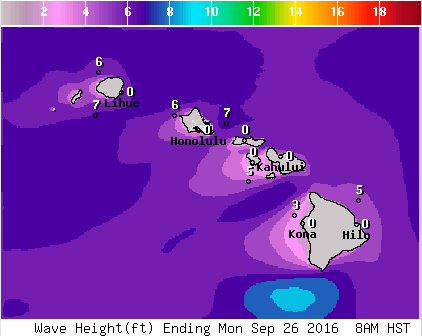
**Click directly on the images below to make them larger. Charts include: Big Island projected winds, tides, swell direction & period and expected wave heights.**
+
SWIPE LEFT OR RIGHT
Big Island Surf Forecast
Hilo Side: Surf heights are expected to be in the knee to shoulder high range. Small short period wind waves from the east-northeast rising later in the day. Light and variable northwest winds, Increasing later and switching to the north-northeast.
ARTICLE CONTINUES BELOW AD
Kona Side: Surf heights are expected to be in the knee to thigh high range occ. 3ft. Minimal SSW swell.
South: Surf heights are expected to be in the knee to shoulder high range. Small short period wind waves from the east-northeast rising later in the day. Breezy east-northeast winds, whitecapping conditions with moderate choppy seas all day.
Keep in mind surf heights are measured on the face of the wave from trough to crest. Heights vary from beach to beach, and at the same beach, from break to break.
This comments section is a public community forum for the purpose of free expression. Although Big Island Now encourages respectful communication only, some content may be considered offensive. Please view at your own discretion. View Comments