

Pele’s Steam Plume More Prominent
Sept. 16, 2016: “Lava After Storm” video by Tropical Visions Video/Paradise Helicopters
The Tropical Visions Video crew aboard Paradise Helicopters conducted a flyover of Hawai‘i Volcanoes National Park on Friday, Sept. 16.
Hawaiian Volcano Goddess Pele’s steam plume has become more prominent as the eastern-most Pacific Ocean entry in Hawai‘i Volcanoes National Park continues unabated, Tropical Visions reported.
Fluid pahoehoe flows cover the better part of a mile of the recently rebuilt access road, giving visitors a direct path to the action.
This new flow, dubbed 61g, is now about six miles long, and the ocean entry is completely within the boundary of Hawai‘i Volcanoes National Park.
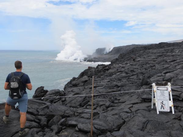
Visitors continue to make their way on foot, but more access the area by boat, getting up close and personal to the amazing spectacle, Tropical Visions reported. The safe viewing area has been laid out well back from the active ocean entry, and the US Geological Survey has issued warnings about the potential hazards there.
The crew reported that the Pu‘u ʻŌʻō lava lake was obscured, but still offered a glimpse and some spattering activity.
Under trade wind conditions, Kīlauea Volcano’s eastern Kamokuna lava delta is more safely viewed from outside the closed area on the east, or Kalapana, side of the ocean entry. Today, trade winds were blowing the billowy white ocean entry plume, a mixture of superheated steam, hydrochloric acid, and tiny shards of volcanic glass, away from the viewing area. Noxious volcanic fume from the active lava tube, visible to the right of the plume, should also be avoided by staying upwind of the ocean entry, which today, was at this location. USGS Hawaiian Volcano Observatory photo.
CAUTION TO OCEAN ENTRY VISITORS
The USGS has issued a strong caution to visitors viewing the 61g flow ocean entry. There are additional, significant hazards besides walking on uneven surfaces and around unstable, extremely steep sea cliffs.
Venturing too close to an ocean entry exposes you to flying debris created by the explosive interaction between lava and water.
Also, the new land created is unstable because it is built on unconsolidated lava fragments and sand. This loose material can easily be eroded away by surf, causing the new land to become unsupported and slide into the sea. In several instances, such collapses, once started, have also incorporated parts of the older sea cliff.
Finally, the interaction of lava with the ocean creates an acidic plume laden with fine volcanic particles that can irritate the skin, eyes and lungs.
HAWAIIAN VOLCANO OBSERVATORY UPDATE
Tuesday, Sept. 20, 2016, 9:27 a.m.
Activity Summary: Kīlauea Volcano continues to erupt at its summit and from its East Rift Zone. Summit tiltmeters recorded continued inflationary tilt, and the lava lake rose slightly.
The 61g lava flow fed from Puʻu ʻŌʻō in the East Rift Zone has been entering the ocean at Kamokuna and there have been breakouts about 1.2 miles inland from the coast.
The 61g flow poses no threat to nearby communities.
Lava Flow Observations: The 61g lava flow, extending southeast from Puʻu ʻŌʻō on Kīlauea’s south flank, continues to supply lava to the ocean near Kamokuna. A satellite image from yesterday confirms that active breakouts are present on the coastal plain, and remain about 1.2 miles inland from the ocean entry.
Summit Observations: Summit tiltmeters recorded continued inflationary tilt over the past day. The lake surface rose over the past day, and was visible from Jaggar Overlook last night. The lake surface was measured at 39 feet below the floor of Halema‘uma‘u this morning.
Webcam views of the lava lake can be found online.
Summit seismicity was at typical levels, while volcanic tremor amplitudes continued to fluctuate in association with lava lake spattering. Average daily summit sulfur dioxide emission rates ranged from 3500 to 6200 metric tons/day over the past week. GPS and InSAR data show continued long-term inflation of the summit magma reservoir complex, ongoing since 2010.
Puʻu ʻŌʻō Observations: There were no noteworthy geological changes at Puʻu ʻŌʻō over the past day, nor were there any significant changes or trends in seismicity or surface deformation. The sulfur dioxide emission rate from all East Rift Zone vents was about 270 metric tons/day when last measured on Sept. 7.


Sponsored Content

