Video by Mick Kalber, Tropical Visions Video, at 6 a.m., Thursday Sept. 8, 2016.
Paradise Helicopters with Mick Kalber of Tropical Visions Video conducted a flyover of Volcanoes National Park at 6 a.m., Thursday Sept. 8, 2016, observing that the 61g ocean entry has broadened an is now about 6 miles long.
“Volcano Goddess Pele continues battle with her sister Na Maka,” Kalber wrote in an email to Big Island Now.
“Na Maka, Goddess of the Sea, is broadening her flow further into Hawai‘i Volcanoes National Park and at numerous points in the Pacific Ocean,” Kalber reported. “Pele’s fluid pahoehoe flows now cover the better part of a mile of recently completed access road, as she has spread into the park.
ARTICLE CONTINUES BELOW AD
ARTICLE CONTINUES BELOW AD
“Pele rolled over Pulama Pali six weeks ago, mostly between Hawai‘i Volcanoes National Park and the abandoned Royal Gardens subdivision,” said Kalber. “This new flow, dubbed “61g” is now about 6 miles long, and the ocean entry is within the boundary of Hawai‘i Volcanoes National Park.
The USGS Hawaiian Volcano Observatory confirms that the 61g lava flow, extending southeast from Puʻu ʻŌʻō on Kīlauea’s south flank, continues to supply lava to the ocean near Kamokuna.
Last weekend, HVO observers found that persistent noxious volcanic fumes downwind from the ocean entry area necessitated the use of respirators. On Monday, Sept. 5, a large section of the western ocean entry delta collapsed into the ocean, triggering a small explosion.
Visitors continue to make their way on foot and by boat to take in the view, Kalber said.
ARTICLE CONTINUES BELOW AD
“Although the safe viewing area has been laid out well back from the active ocean entry, many photographers and curiosity seekers enter the restricted areas,” said Kalber.
USGS Hawaiian Volcano Observatory Caution to Visitors
A strong caution to visitors viewing the 61g flow ocean entry: There are additional significant hazards besides walking on uneven surfaces and around unstable, extremely steep sea cliffs.
Venturing too close to an ocean entry exposes you to flying debris created by the explosive interaction between lava and water. Also, the new land created is unstable because it is built on unconsolidated lava fragments and sand. This loose material can easily be eroded away by surf, causing the new land to become unsupported and slide into the sea.
ARTICLE CONTINUES BELOW AD
In several instances, such collapses, once started, have also incorporated parts of the older sea cliff. Finally, the interaction of lava with the ocean creates an acidic plume laden with fine volcanic particles that can irritate the skin, eyes, and lungs.
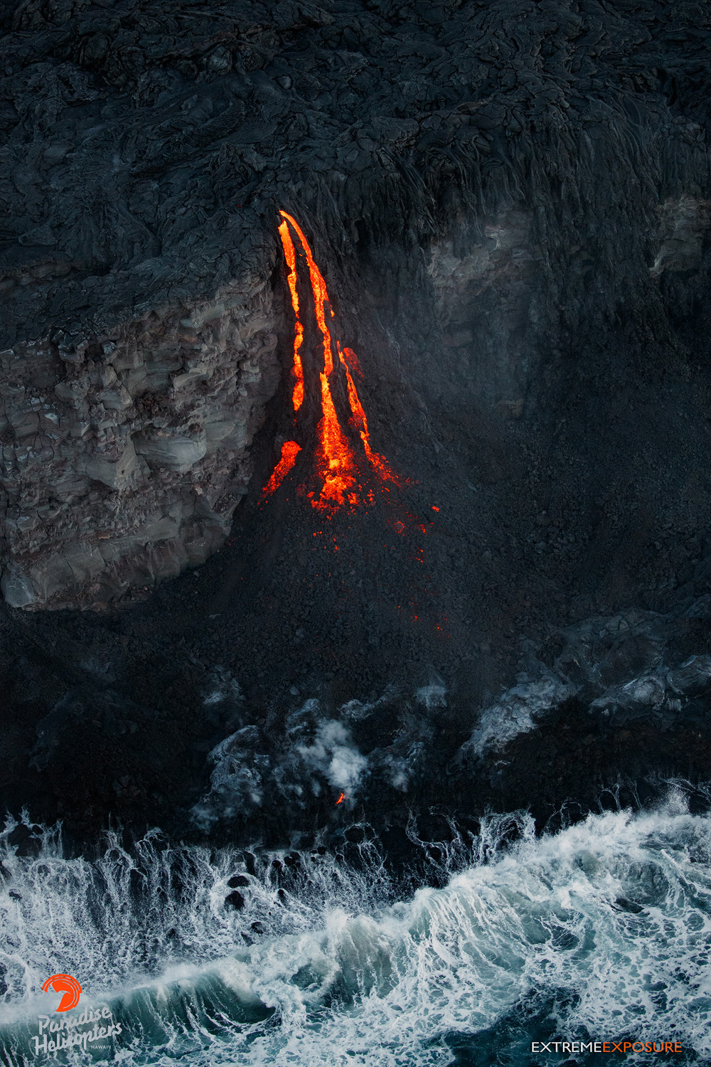
Lava transforms from pahoehoe to ‘a‘a as it cascades down the face of a sea cliff on the Kalapana coastline, building a new delta of land at its base. Paradise Helicopters photo.
Activity Summary: Kīlauea Volcano continues to erupt at its summit and from its East Rift Zone. The lava lake at Kīlauea’s summit dropped slightly overnight but remains high and spattering is visible from the Jaggar Museum. Summit tiltmeters show deflationary tilt beginning late yesterday. The 61g lava flow fed from Puʻu ʻŌʻō in the East Rift Zone continues to enter the ocean at Kamokuna. The 61g flow poses no threat to nearby communities.
Summit Observations: The lava lake within the Halemaʻumaʻu Overlook vent remains active and at a relatively high level, with spattering easily visible from Jaggar Museum. The lake surface was 26 feet below the adjacent floor of Halemaʻumaʻu crater last night, but has dropped slightly since that time. This morning, the lake surface was about 20 66 feet below the floor of Halemaʻumaʻu. The drop in lake level overnight coincided with deflationary tilt recorded by summit tiltmeters beginning Wednesday, Sept. 7, 6 p.m.
There were no significant changes in seismicity over the past day, while volcanic tremor amplitudes continue to fluctuate in association with lava lake activity. Average daily summit sulfur dioxide emission rates ranged from 3,100 to 6,400 metric tons/day over the past week. GPS and InSAR data continue to show long-term inflation of the summit magma reservoir complex, ongoing since 2010.
Puʻu ʻŌʻō Observations: At Puʻu ʻŌʻō, webcam views suggest no significant geological changes, and no significant changes or trends in seismicity or surface deformation are noted. The sulfur dioxide emission rate from all East Rift Zone vents was about 260 metric tons/day when last measured on Sept. 1.
This comments section is a public community forum for the purpose of free expression. Although Big Island Now encourages respectful communication only, some content may be considered offensive. Please view at your own discretion. View Comments