Hurricane Lester Weather Impacts
Click here for the latest updates on Hurricane Lester
Friday, Sept. 2, Weather Forecast, Hurricane Watch Dropped
Click here for Friday, Sept. 2, 6 a.m. video update with Malika Dudley
Click here for business and school reopenings
Click here for emergency shelter information
Click here for power, road and flooding status reports
Click here for hurricane safety tips
Click here for airline information
Click here for Hurricane Madeline photos from across Hawai‘i County
Here is a summary of the expected weather conditions for the Big Island as Madeline departs and Lester approaches. Meteorologist Malika Dudley will be doing LIVE weather updates on our BigIslandNow.com Facebook page. Here is a link to the 5 a.m. video forecast.
Madeline Weather Effects & Today’s Forecast
A Wind Advisory is posted for the island of Hawaii through 6 p.m. tonight with winds out of the E & NE from 25-35 mph, gusting to 50 mph in some spots. Winds this high can bring down tree branches and lead to power outages.
Mostly cloudy skies are forecast for windward spots with light to moderate trade showers and improving conditions. Partly sunny for the Kona side with just isolated showers today.
Surf wise, our High Surf Warning has been replaced by a High Surf Advisory for eastern shores. Brown water is likely to be a concern. Wave heights of 8 to 12 foot faces are expected today with a gradual decrease throughout the day as Madeline continues to move away from the islands. A Gale Warning is posted for the Alenuihaha channel with seas of 9 to 13 feet there. The Gale Warning is also up for waters to the west and south, with a Small Craft Advisory posted for the east side.
All Warnings with regard to Madeline have been discontinued.
Lester Weather Effects
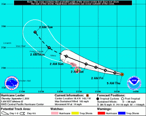
According to the Central Pacific Hurricane Center, hurricane Lester is forecast to approach the state from the east over the next couple of days. The current Central Pacific Hurricane Center forecast brings Lester very close to the main Hawaiian islands Saturday and Sunday. Depending on the exact track that Lester takes, strong damaging winds and heavy rainfall are possible. Large and damaging surf is expected for east facing shores as well. It is still too early to determine which island is at most Risk from Lester.
WIND:
HURRICANE WATCH – Big Island
Tropical storm conditions (39 mph +) are possible as early as late Friday and hurricane conditions (74 mph +) are possible Saturday. The chance for hurricane conditions at Hilo is 2 percent and Kailua-Kona is 1 percent. The chance for tropical storm conditions at Hilo is 35 percent, at Kailua-Kona is 27 percent and at South Point 16 percent.
Depending on the exact track of Lester, there is the possibility of significant wind damage, including downed trees and power lines, and damage to roofs and weak structures.
RAIN:
Deep moisture associated with Lester is expected to begin late Friday with the threat of heavy flooding rainfall continuing through Sunday. This rainfall could possibly lead to dangerous flash floods and mudslides.
SURF:
A High Surf Advisory is likely to be issued Friday. High Surf Warnings could pop up over the weekend.
Large and damaging surf is possible along east facing shores. Surf is expected to build to 15 to 25 feet Friday night into Saturday and continue through Sunday. This may cause significant wave run-up or damage to coastal properties and infrastructure, including roadways. Powerful longshore and rip currents will be present at most beaches. Large breaking waves and strong currents may impact harbor entrances and channels causing challenging boat handling.


