The National Weather Service has issued a Tropical Storm Warning for Hawai‘i County. Conditions produced by Tropical Storm Darby are possible within the warning area in the next 36 hours, including high winds upwards of 39 mph, heavy rains and storm generated surf.
UPDATE: Saturday, July 23, 9:29 p.m.
The National Weather Service has issued a flash flood warning for Hawai‘i County until 12:30 a.m.
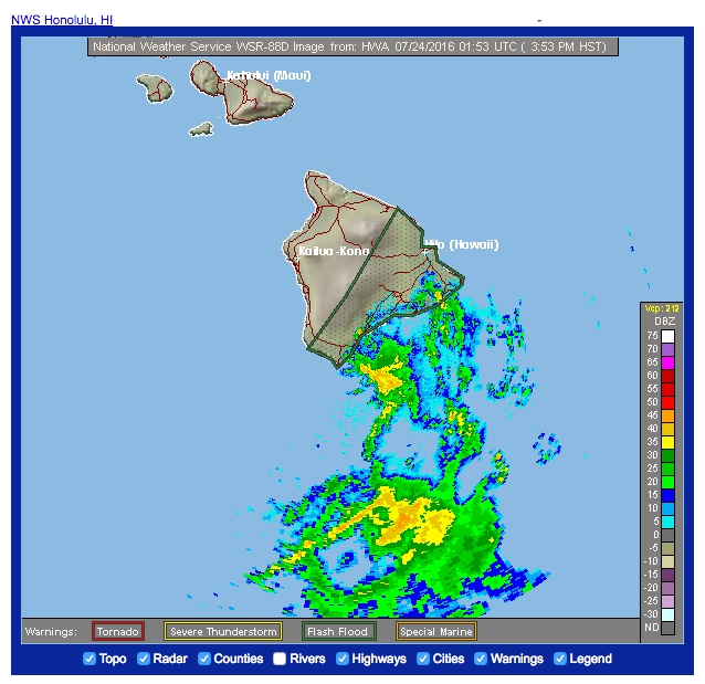
At 923 p.m., radar showed a large band of heavy rain moving onshore into the Ka‘u District from east of Volcano to South Point.
ARTICLE CONTINUES BELOW AD
ARTICLE CONTINUES BELOW AD
The heavy rain will continue moving slowly to the northwest into upslope areas with rainfall rates of 2 to 3 inches per hour likely.
The ground is already saturated in this area from earlier heavy rains. Excessive runoff is likely and
Highway 11 at Kawa Flats may be vulnerable to closure due to flooding.
Locations in the warning include but are not limited to Hawaiian Paradise Park, Na‘aleahu, Hawaiian Ocean View, Pahoa, Pahala, Glenwood, Hawaiian Acres and Kawa Flats.
+
SWIPE LEFT OR RIGHT
CLOSURES: Saturday, July 23
Hilo Harbor, Kawaihae Harbor The Coast Guard closed Hawai‘i County ports to all traffic. All cargo operations in these ports are secured. Vessels transiting within the vicinity of the Hawaiian Island harbors should seek sheltered waters until storm conditions subside and it has been determined that the ports safe to reopen.
ARTICLE CONTINUES BELOW AD
Once the storm has passed and the threat of severe weather has subsided, the Coast Guard, Army Corp of Engineers and State of Hawaii will jointly conduct surveys of channel blockage and prioritize steps to resume essential, then normal, vessel traffic. Port Assessment Teams will be sent to accessible areas of the zone as soon as it is safe to do so over the weekend.
The Coast Guard will continue to broadcast Notice to Mariners and post Marine Safety Information Bulletins on homeport.uscg.mil/Honoluluto notify the reopening of ports and any special conditions.
First Hawaiian Bank First Hawaiian Bank closed its Kamuela Branch (Kamuela Shopping Center, 67-1189 Mamalohoa Highway) today. Hilo (Hilo Shopping Center, 1205 Kilauea Ave.) and Kona (74-5593 Palani Road) branches will remain open until 1 p.m. Customers with Internet may also access their accounts via FHB Online.
Hele-On Bus service is suspended today. Solid waste transfer stations and landfills are closed today.
Umauma Bridge on Highway 19 remains closed with a detour through Old Mamalahoa Highway.
ARTICLE CONTINUES BELOW AD
State forest and park areas.All forest reserves, wildlife sanctuaries, natural area reserves, Na Ala Hele hiking trails, forest campgrounds and game management areas, including Keanakolu cabins, Ainapo hiking trail, Muliwai trail and Waimanu valley campground until further notice. Camping permits for this weekend are cancelled until further notice. Saturday’s planned cattle hunt will be cancelled.
Partial closure of Hawaii Volcanoes National Park: Kūlanaokuaiki Campground & Nāmakanipaio Cabins and Campgrounds, Hilina Pali Road, Chain of Craters Road at the Crater Rim Drive intersection, Lava viewing area and Coastal Ranger Station, Mauna Loa Road after Kīpukapuaulu, Kahuku)
Kaloko-Honokōhau and Pu‘uhonua o Hōnaunau National Historical Parks will be closed on Saturday. Will reopen when conditions allow.
Downtown Farmers Market is closed.
Downtown Hilo stores are closed.
County swimming pools are closed.
Lava viewing in Kalapana will be closed through Sunday.
Waiopae Tide Pools at Kapoho will be closed through the weekend.
All county solid waste transfer stations and landfills closed on Saturday.
Umauma Bridge on Highway 19 will be closed at midnight. Detour through Old Mamalahoa Highway.
CANCELLATIONS
All camping reservations at county parks are being cancelled from Friday to Sunday.
Pavilion reservations at county parks are also being cancelled on Saturday and Sunday.
All athletic practices and events at Kea‘au high school cancelled.
UH Hilo summer swim originally scheduled for today and tomorrow, has been rescheduled to Monday and Tuesday.
All athletic events at Kamehameha-Hawai‘i has been cancelled through Sunday.
Hilo Hongwanji Obon Dance and floating lantern festival cancelled for this Saturday and Sunday.
Shakespeare in the Park is cancelled today, July 23). Performance will resume Sunday, July 24, afternoon for a matinee performance if the parks are open.
Kids Shakespeare is cancelled this weekend.
KAPA Back to School Drive will be postponed until Saturday, July 30.
2015 Miss Teen Lehua Hawaii & Young Miss Lehua Hawaii are cancelled.
Maku’u Farmers Market cancelled on Sunday, July 24.
Next week’s Jimmy Yagi Hoops Camp has been moved from the Afook-Chinen Civic Auditorium to the UH at Hilo Gymnasium
Oceanic Time Warner Cable’s Hilo office will close at noon July 23.
KTA Keauhou Re-Grand Opening celebration has been postponed.
Hawaiian Telcom is postponing utility work near the intersection of Mamalahoa Highway and Napo‘opo‘o Road, which was scheduled to start this weekend. Work will begin next weekend.
All HFS Federal Credit Union and Bank of Hawaii locations will be closed on Saturday.
The Kohala Mountain Education Farm is canceling the Saturday, Sunday and Monday of its Summer Festival.
Kinoole Farmers Market closed for Saturday
SHELTER UPDATE: July 23, 2:57 p.m.: On Friday evening, 109 people stayed overnight in Big Island shelters.
SHELTERS OPEN
Laupahoehoe High – 35-2065 Old Mamalahoa Hwy., Laupahoehoe
Kohala High & Elementary – 54-3609 Akoni Pule Hwy., Kapa‘au
Konawaena High (pet friendly)– 81-1043 Konawaena School Rd., Kealakekua
Hilo High – 556 Waianuenue Ave., Hilo
Waiakea High (pet-friendly) – 155 W Kawili St., Hilo
Kea‘au High (pet friendly) – 16-725 Kea‘au-Pahoa Rd,. Kea‘au
Pāhoa High & Intermediate (pet-friendly) – 15-3038 Pāhoa Village Road, Pāhoa
Honoka‘a High & Intermediate (pet-friendly) – 45-527 Pakalana St, Honoka‘a
Ka‘u High & Elementary (pet-friendly) – 96-3150 Pikake St., Pahala
Families are asked to bring their own disaster supplies kit to a shelter, if asked to evacuate.
Have seven days’ worth of supplies at home to shelter in place or in a compact portable container to take to a shelter.
Full details about what the kit should contain are available online.
Water – 1 gallon per person per day
Food – non-perishable
Flashlight
Radio -NOAA Weather Radio
Extra batteries
First aid kit
Medications & Medical items
Manual Can opener
Multi-purpose tool
Personal hygiene items
Copies of Documents (prescriptions, proof of address, deed/lease to home, insurance policies and proof of identity
Cell phone with chargers
Family Contact Information
Cash
Bedding
Change of clothes
Towels
Dishes
Other possible needs
Baby supplies – bottles, baby food & diapers
Games and activities
Comfort items
Pet supplies – collar, leash, ID, food, water, carrier, bowl and medications
MAKE A PLAN
All members of the household should work together on the family disaster plan. A Family Disaster Plan Template is available on redcross.org that people can download and complete to make or update their plan.
Planning together is important so everyone in the household knows what they should do if something occurs. The plan should include ways to contact and find one another in an emergency, including two places to meet—one near the home in case of a sudden emergency like a fire and one outside the neighborhood in case circumstances prevent people from returning home.
Choose an out-of-area emergency contact person. It may be easier to text or call long distance if local phone lines are overloaded or out of service.
PREPARE FOR FLOODING
When a flood or flash flood warning is issued for your area, head for higher ground and stay there. Stay away from floodwaters. If you come upon a flowing stream where water is above your ankles, stop, turn around and go another way. If you come upon a flooded road while driving, turn around and go another way. If you are caught on a flooded road and waters are rising rapidly around you, get out of the car quickly and move to higher ground. Most cars can be swept away by less than two feet of moving water. Keep children out of the water. They are curious and often lack judgment about running water or contaminated water. For more flood safety tips: http://www.redcross.org/get-help/prepare-for-emergencies/types-of-emergencies/flood#/Prepare.
STAY INFORMED
Listen to local media to keep updated on the status of Tropical Storm Darby. Evacuation shelter locations and opening times will be shared by local media. Do not automatically go there.
Download free Red Cross mobile apps. Have safety and first aid information at your fingertips. The hurricane app features weather alerts, information on open Red Cross shelters, a toolkit with a flashlight, strobe light and alarm, and a one-touch “I’m Safe” button that lets you use social media outlets to let family and friends know you are okay. The apps can be downloaded by visiting redcross.org/apps.
PREVIOUS UPDATES FOR JULY 23
UPDATE: July 23, 8 p.m.
The flash flood warning has been downgraded to a flood advisory for Puna and Ka‘u Districts.
A High Surf Warning for east facing shores and a Tropical Storm Warning for the entire island remains in effect for Hawai‘i County.
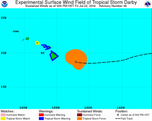
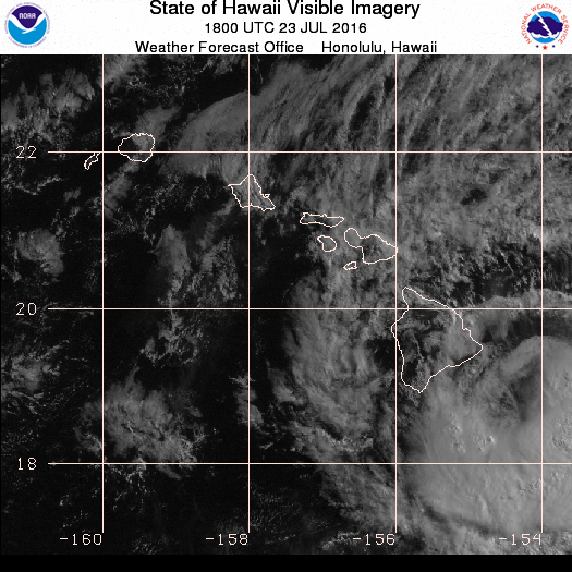
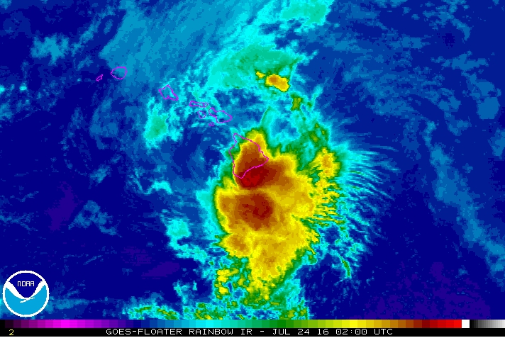
As of 8 p.m., the National Weather Service reports Tropical Storm Darby is located about 25 miles Southwest of Kailua-Kona moving to the west at 11 miles per hour.
Maximum sustained winds are 40 miles per hour with higher gusts.
UPDATE: July 23, 7:58 p.m.
The National Weather Service has issued a flood advisory for Hawai‘i Island until 11 p.m. HST.
At 7:56 p.m., radar indicated a large area of moderate to locally heavy rain extending from South Point along the coast of the Ka‘u and Puna Districts. This area of rain is moving slowly to the north. Rainfall rates of 1 to 2 inches per hour will be possible
Locations in the advisory include but are not limited to Kawa Flats, Mountain View, Naa‘alehu, Hawaiian Ocean view, Pāhoa, Volcano, Pahala and Hawai‘i Volcanoes National Park.
UPDATE: July 23, 5:55 p.m.
The center of tropical storm Darby will move off the leeward side of Hawai‘i Island this evening and over the leeward coastal waters near the islands tonight and Sunday. Darby will weaken over the next couple of days. However, locally strong winds and heavy rain will remain possible in association with Darby for a while longer.
UPDATE: July 23, 5:30 p.m.
The National Weather Service has extended the Flash Flood Warning for the Puna and Ka‘u Districts of Hawai‘i County until 8 p.m.
UPDATE: July 23, 3:20, 4 & 4:54 p.m.
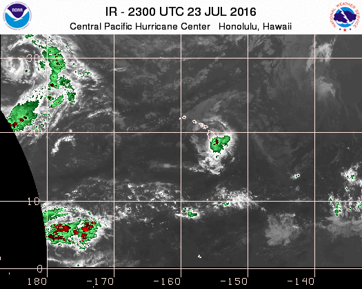
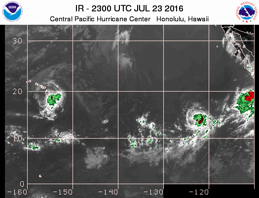
The NWS Central Pacific Hurricane Center reports that the center of Tropical Storm Darby made landfall at about 2 p.m. along the Ka‘u Coast, about 10 miles east-northeast of Pahala and very close to the location where Tropical Storm Iselle made landfall in 2014. It is moving over Mauna Loa’s slopes.
A flash flood warning has been issued for the Puna and Ka‘u Districts of the Big Island until 5 p.m. today.
Highway 11 may be vulnerable to closure with any significant additional rain.
The poorly-defined center of Darby is forecast to pass over Hawai‘i Island today, south of Maui County early Sunday, and close to O‘ahu and Kaua‘i late Sunday or Monday.
Darby will weaken over the next couple of days. However, locally strong winds and heavy rain will remain possible in association with Darby for a while longer.
Darby will weaken over the next couple of days. However, locally strong winds and heavy rain will remain possible for a while longer. A High Surf Warning for east facing shores and a Tropical Storm Warning for the entire island remains in effect for Hawaii County.
As of 2 p.m. today, the NWS reported that Darby is located about 45 miles South of Hilo moving to the West-North-West at 10 miles per hour.
Maximum sustained winds are 40 miles per hour with higher gusts.
UPDATE: July 23, 2:07 p.m.
The National Weather Service has extended the flood advisory for Hawai‘i Island through 5 p.m. HST.
At 2:02 p.m., radar indicated heavy rain moving onshore from the east and southeast. Rainfall will spread across the Puna and Ka‘u Districts over the next several hours as the center of Darby
approaches Hawai‘i Island.
Affected areas in the warning include but are not limited to Hilo, Pāhao, Mountain View, Glenwood, Hawai‘i Volcanoes National Park, Wood Valley, Pahala, Na‘alehu and Kawa flats.
Move to higher ground now.
UPDATE: Saturday, July 23, 11 a.m.
Civil Defense has downgraded the flash flood warning for Hawai‘i Island to a flood advisory. A flood advisory means minor, general or area flooding is occurring, imminent or highly likely in flood prone areas.
The High Surf Warning for east facing shores and a Tropical Storm Warning for the entire island remains in effect for Hawaii County.
As of 11 a.m. today, Tropical Storm Darby is located about 60 miles south-southeast of Hilo moving to the west at 10 miles per hour. Maximum sustained winds are 45 miles per hour with higher gusts.
Rain and wind from Tropical Storm Darby are affecting the Big Island. Residents are urged to stay off the road if at all possible.
UPDATE: July 23, 11:27 a.m.
The National Weather Service has extended the flood advisory for Hawai‘i Island through 2:15 p.m.
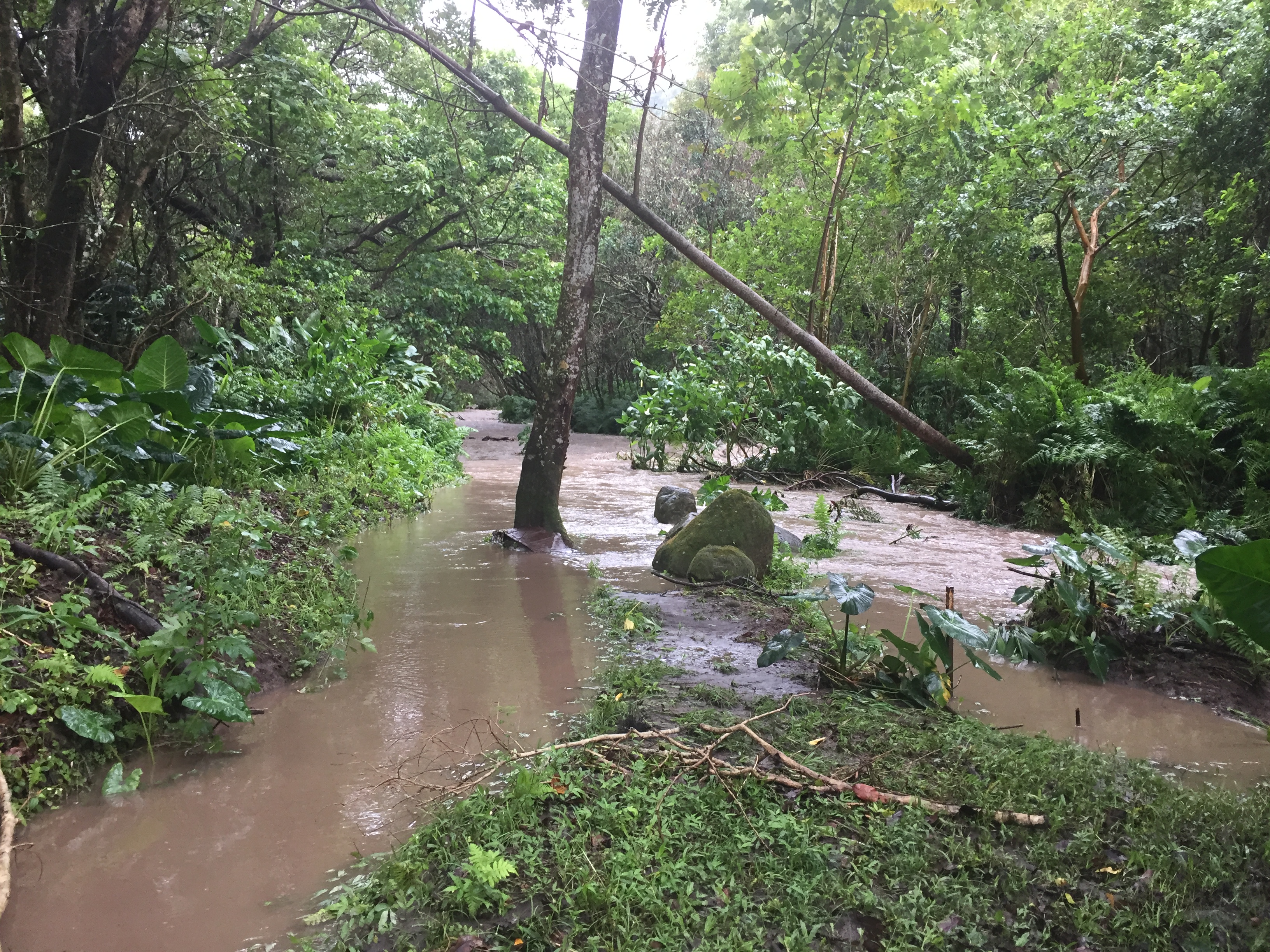
At 11:20 a.m., radar and rain gages showed that rainfall over the windward slopes will continue to produce minor flooding and elevated stream levels.
Locations in the tropical storm/flood advisory includes all locations in the North Kohala,
South Kohala, Hamakua, North Hilo, South Hilo and Puna Districts.
UPDATE: July 23, 9 a.m.
National Weather Service has issued a flash flood warning for North and South Kohala, Hamakua, North and South Hilo and Puna until 11:30 a.m. today.
A High Surf Warning for east facing shores and a Tropical Storm Warning for the entire island remains in effect for Hawai‘i County.
As of 8 a.m. today, Tropical Storm Darby is located about 80 miles southeast of Hilo moving to the west at 9 miles per hour. Maximum sustained winds are 50 miles per hour with higher gusts.
Rain and wind from Tropical Storm Darby are affecting Hawai‘i Island. Residents are urged to stay off the road if at all possible.
Should power be lost or access be blocked-ensure you have prescription medications, ice, water, oxygen, backup power and fuel if needed.
To keep everyone safe, all state and county park facilities and remote areas of Hawaii Volcanoes National Park are closed until further notice.
UPDATE: July 23, 9 a.m.
The National Weather Service has issued a Flash Flood Warning for Hawai‘i County until 11:30 a.m.
Affected areas include North Kohala, South Kohala, Hamakua, North Hilo, South Hilo and Puna Districts.
Motorists are advised to beware of ponding and runoff.
UPDATE: July 23, 8:23 a.m.
From the National Weather Service in Honolulu:
Emergency Management reported flooding has closed Kapuna Road in the Hamakua District.
Radar showed maximum rain rates of 1 to 2 inches per hour along the Kohala and Hamakua slopes.
Additional rain bands associated with approaching Tropical Storm Darby will continue to move over the windward slopes of Hawai‘i island through the day.
A flash flood warning means that flooding in imminent or occurring in
streams, roads and low-lying areas. Move to higher ground now.
Do not cross fast flowing water in your vehicle or on foot. Turn around, don’t drown.
UPDATE: July 23: 7:17 a.m.
The National Weather Service in Honolulu release update stated that at 7:08 a.m., radar indicated heavy rain over the windward slopes of Hawai‘i Island.
The heaviest rainfall, with rates 1 to 2 inches per hour, was occurring over the Kohala Mountains and the Puna slopes.
Additional rain bands associated with approaching Tropical Storm Darby will continue through the day.
Locations in the tropical storm/flood advisory includes all locations in the North Kohala,
South Kohala, Hamakua, North Hilo, South Hilo and Puna Districts.
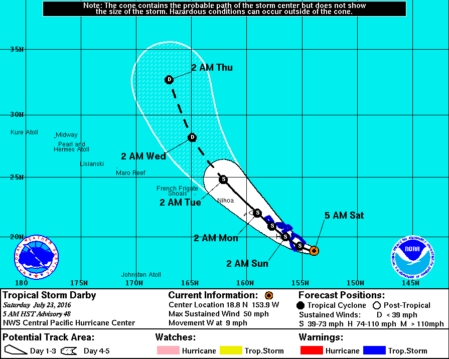
UPDATE: July 23, 5 a.m.
The Central Pacific Hurricane Center released a discussion about Tropical Storm Darby at 5 a.m. HST on Saturday, July 23, 2016.
The 5 a.m. forecast track takes Darby to Hawai‘i Island in 12 hours.
The forecast calls for slow weakening with Darby maintaining tropical storm strength through the weekend.
While initial intensity is decreased to 50 mph, this forecast weakening trend is consistent with the previous forecast.
Darby may weaken quickly or may remain as a tropical storm through day five.
Deep convection associated with Darby has increased once again this morning, with the bulk of this activity now across the system’s southeast semicircle.
Outflow remains best within the northeast quadrant, but is restricted throughout the south semicircle, thanks to continued 8 to 11 mph southwest shear.
Low cloud swirls east of the LLCC add confidence to the initial position based heavily on satellite fixes.
However, Darby continues to defy predictions to gain latitude. Given the continued messy satellite presentation and the lack of aircraft data, it’s possible that this system is a tenth of a degree or two farther south.
The next forecast may benefit from land-based weather radar position estimates.
Initial intensity has decreased to about 50 mph.
The next aircraft reconnaissance mission will be later this morning.
Initial motion has a gradually slowed over the past 12 hours.
Darby has not gained latitude over the past six hours and we may find out later that a small southward component exists when radar estimates become available.
Darby is moving westward along the southern flank of the subtropical ridge.
Global models continue to depict a weakness in this ridge between 150W and 160W due to low pressure digging in from the north.
All models continue to show Darby slowing and gradually turning northwest along various curving paths through the next five days, with all tracks crossing Hawai‘i Island.
The right track takes Darby over O‘ahu after passing across leeward waters.
Another model takes Darby west of Kaua‘i after its encounter with Hawai‘i Island.
It is important to note that weakening due to land interaction has so far been ignored for that portion of the track beyond Hawai‘i Island.
It is important not to focus too closely on the exact track and intensity forecasts because the average track error 72 hours out is near 100 miles, while the average intensity error is about 18 mph.
In addition, the hazards of a tropical cyclone can extend over a broad area well away from the center.
For a list of County Emergency Shelters and what you should bring, click here.
UPDATE: July 23, 5:30 a.m.
Darby wind speeds, July 23, 2016, 5 a.m.
The National Weather Service has issued a Tropical Storm Warning for Hawai‘i County.
A High Surf Warning for east facing shores is also in effect.
A Flash Flood Advisory is in effect for Hawai‘i County.
As of 5 a.m. today, Tropical Storm Darby is located about 100 miles southeast of Hilo moving to the west at 9 miles per hour.
Maximum sustained winds are 50 miles per hour with higher gusts.
Rain and wind from Tropical Storm Darby are affecting Hawai‘i Island.
Residents are urged to stay off the road if at all possible.
Should power be lost or access be blocked-ensure you have prescription medications, ice, water, oxygen, backup power and fuel if needed.
To keep everyone safe, all State and County park facilities and remote areas of Hawaii Volcanoes National Park are closed until further notice.
Hele-On Bus service is suspended today. Solid waste transfer stations and landfills are closed today.
Umauma Bridge on Highway 19 closed with a detour through Old Mamalahoa Highway.
Deserted Hilo farmers market, July 23. Photo: Marla Walters
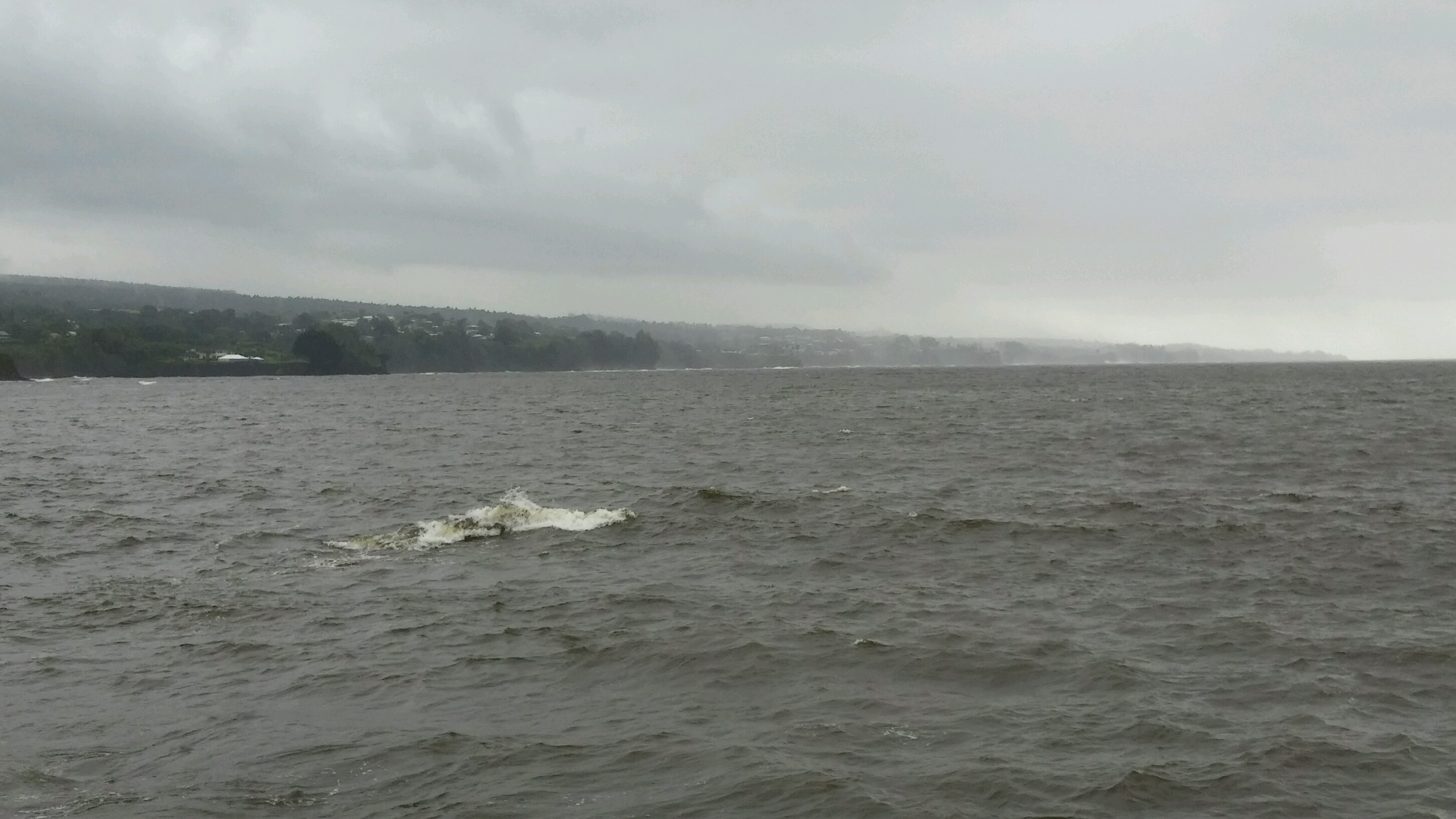
Hilo Bay, July 23. Photo: Marla Walters
Hilo Bay, July 23. Photo: Marla Walters
Rainbow over Hapuna and Mauna Kea Resort, July 23, 8 a.m. Photo: Beth Sundahl
For a list of County Emergency Shelters and what you should bring, click here.
Waimea, July 23, a.m. Photo by Natash Wong-Yuen.
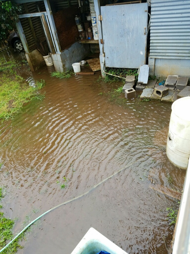
Waipio Valley photo, July 23 a.m. by Darde Gamayo, who said she woke up to waterfall she had never seen before, and the Waipi‘o River overflowed into her yard.
This comments section is a public community forum for the purpose of free expression. Although Big Island Now encourages respectful communication only, some content may be considered offensive. Please view at your own discretion. View Comments