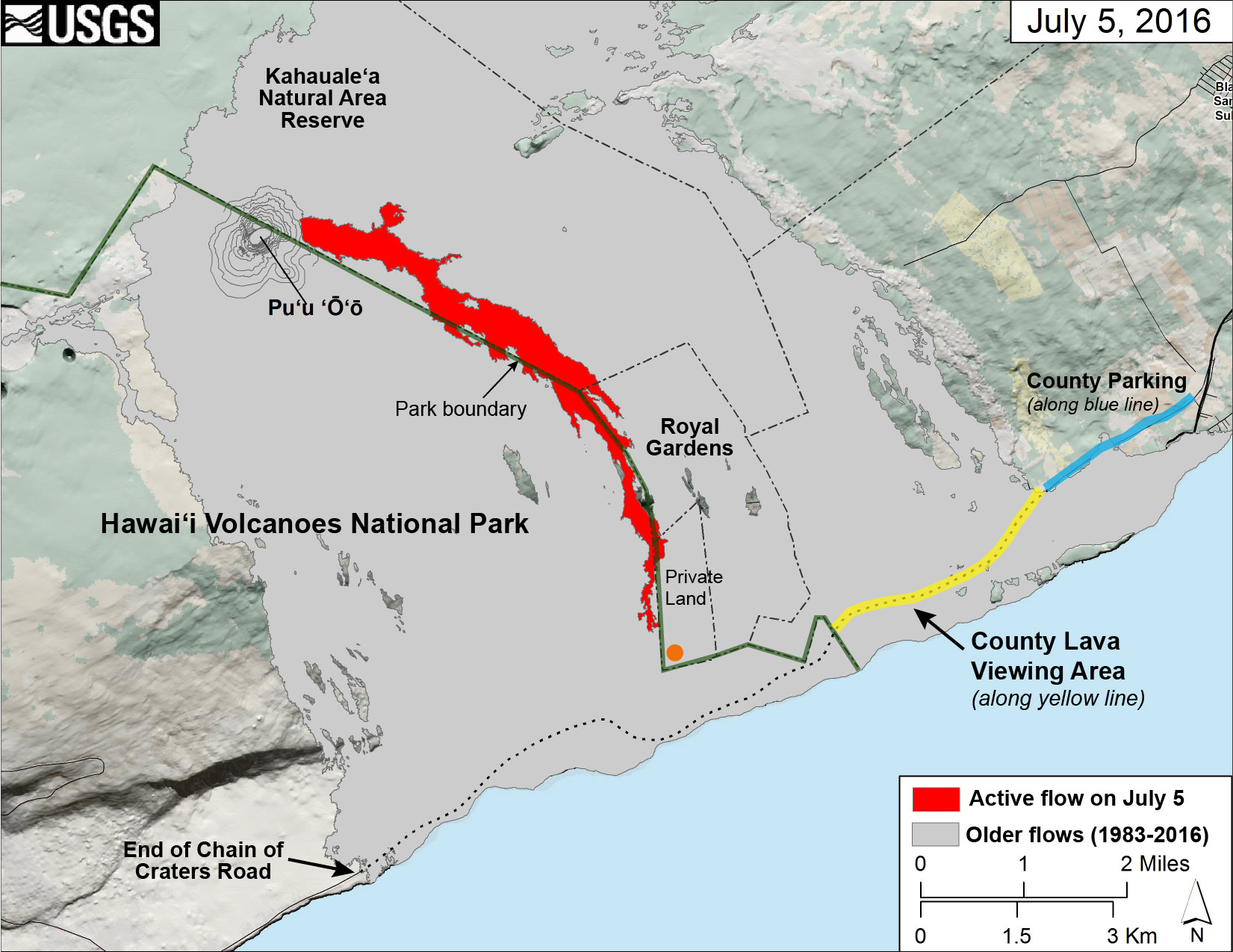
This map of Kīlauea Volcano’s lava flow shows the locations of Hawaiʻi County’s designated lava-viewing and parking areas (http://www.hawaiicounty.gov/lava-viewing/), as well as the lava flow’s location relative to the Hawaiʻi Volcanoes National Park boundary (green line). The full extent of the active lava flow on July 5 is shown in red; an orange dot shows the location of the flow front as of mid-day on July 7. For recent maps and photos of the lava flow, please visit the USGS Hawaiian Volcano Observatory website (http://hvo.wr.usgs.gov). USGS graphic.
Two years ago, Kīlauea Volcano’s “June 27th” flow advanced to the northeast, threatening Pāhoa and creating major disruptions for thousands of residents in the lower Puna district on the Island of Hawaiʻi.
Today, a new flow from Pu‘u ‘Ō‘ō is moving to the southeast along the boundary of Hawaiʻi Volcanoes National Park and could eventually reach the ocean.
As Hawaiʻi residents can appreciate, change is just part of the typical behavior of Kīlauea’s ongoing East Rift Zone eruption.
This new lava flow, informally dubbed the “61g” flow after the eruptive episode sequence the USGS Hawaiian Volcano Observatory uses to document Pu‘u ‘Ō‘ō flows, began on May 24, 2016.
Over the past six weeks, it has advanced to the southeast without interruption. The flow has remained relatively narrow and focused, and consists mostly of pāhoehoe lava, which is typical of Pu‘u ‘Ō‘ō flows in recent years.
ARTICLE CONTINUES BELOW AD
ARTICLE CONTINUES BELOW AD
Around June 23, the 61g flow reached the top of the pali (cliff) above the coastal plain and the upper boundary of the abandoned Royal Gardens subdivision, which is almost completely buried by earlier Pu‘u ‘Ō‘ō lava flows. As the flow continued to advance, it picked up speed on steep sections of the pali, forming impressive ‘a‘ā lava channels on the slopes.
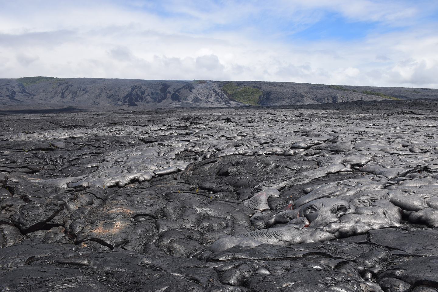
As Kīlauea Volcano’s active pāhoehoe flow spreads across the coastal plain on July 6, the new lava appeared more shiny or silvery compared with the older lava beneath it. Molten “toes” of lava breaking out from the leading edges of the flow can be seen in the lower right quadrant of the photo. USGS photo.
Within a few days, the flow front reached the base of the pali and began its advance across the coastal plain. There, the flow front narrowed even more, perhaps because it was confined by nearby high ground created by earlier Pu‘u ‘Ō‘ō flows. This focusing of the flow probably contributed to its high advance rate on the coastal plain.
The 61g flow front initially moved across the coastal plain at a rate of up to 600 m (about 0.4 mi) per day, which is fairly rapid compared with other Pu‘u ‘Ō‘ō pāhoehoe flows. As of mid-day on July 7, the flow front was about 1.2 km (.7 miles) from the ocean, and still moving at a good clip.
Given the flow’s current advance rate, lava could reach the ocean for the first time since August 2013 in the coming days or weeks. However, the flow’s advance could slow, spreading lava across the coastal plain rather than into the ocean, or it could stall.
Compared to the June 27th flow, which threatened Pāhoa and nearby subdivisions, the location of the 61g lava flow presents no immediate hazard to residential areas. It is currently overrunning older Pu‘u ‘Ō‘ō lava flows a safe distance from the nearest homes.
ARTICLE CONTINUES BELOW AD
Although the hazard to property has diminished, the potential hazard to people is greater now that the flow is more accessible. The opportunity to see an active lava flow is already drawing hundreds of visitors hoping for a glimpse of lava to Kīlauea’s south coast.
Besides the obvious dangers of molten lava (burns, exposure to fumes), hiking to a lava flow is risky for a number of reasons, including the possibility of falling on the rough, uneven terrain, becoming dehydrated, or suffering heat exhaustion or stroke. Heat from above (the sun) and below (hot ground) can rapidly overwhelm even the strongest of hikers. Proper gear—sturdy hiking boots, long pants, gloves, sun protection—and a lot of water are essential for safe hiking.
If lava reaches the sea and forms an ocean entry, new hazards will appear. In general, ocean entries are the most dangerous part of a lava flow field due to unpredictable bench collapses, explosions, and scalding steam plumes. This danger is not theoretical—several people have died near Kīlauea ocean entries in years past.
To safely view the 61g flow, your best plan is to get up-to-date lava-viewing information from Hawaiʻi Volcanoes National Park and the County of Hawaiʻi. These agencies have outlined where and when safe lava viewing is available.
The US Geological Survey offers information on viewing lava safely in an online Fact Sheet. Because it was published in 2000, the map is out of date. However, the hazard information and safety tips provided in the sheet are timeless and relevant.
ARTICLE CONTINUES BELOW AD
From home, you can track the progress of Kīlauea’s lava flow through daily eruption updates and recent maps and photos posted on the USGS Hawaiian Volcano Observatory website.
Volcano Activity Updates
Kīlauea continues to erupt at its summit and East Rift Zone. During the past week, the summit lava lake level varied between about 24 m and 35 m (79–115 feet) below the vent rim within Halema‘uma‘u Crater. On the East Rift Zone, the eastern Pu‘u ‘Ō‘ō breakout remained active, producing a lava flow (informally called the “61g flow”) that continued to advance to the southeast. As of mid-day on July 7, 2016, the flow was about 1.2 km (.7 miles) from the ocean. The lava flow does not pose an immediate threat to nearby communities.
Mauna Loa is not erupting. Seismicity rates remain above background levels. Deformation related to inflation of a magma reservoir beneath the summit and upper Southwest Rift Zone continues, with inflation recently occurring mainly in the southwestern part of Mauna Loa’s magma storage complex.
No earthquakes were reported felt on the Island of Hawaiʻi this past week.
Volcano Watch is a weekly article and activity update written by U.S. Geological Survey Hawaiian Volcano Observatory scientists and affiliates.
Call for summary updates at (808) 967-8862 (Kīlauea) or (808) 967-8866 (Mauna Loa); email questions to [email protected].
This comments section is a public community forum for the purpose of free expression. Although Big Island Now encourages respectful communication only, some content may be considered offensive. Please view at your own discretion. View Comments