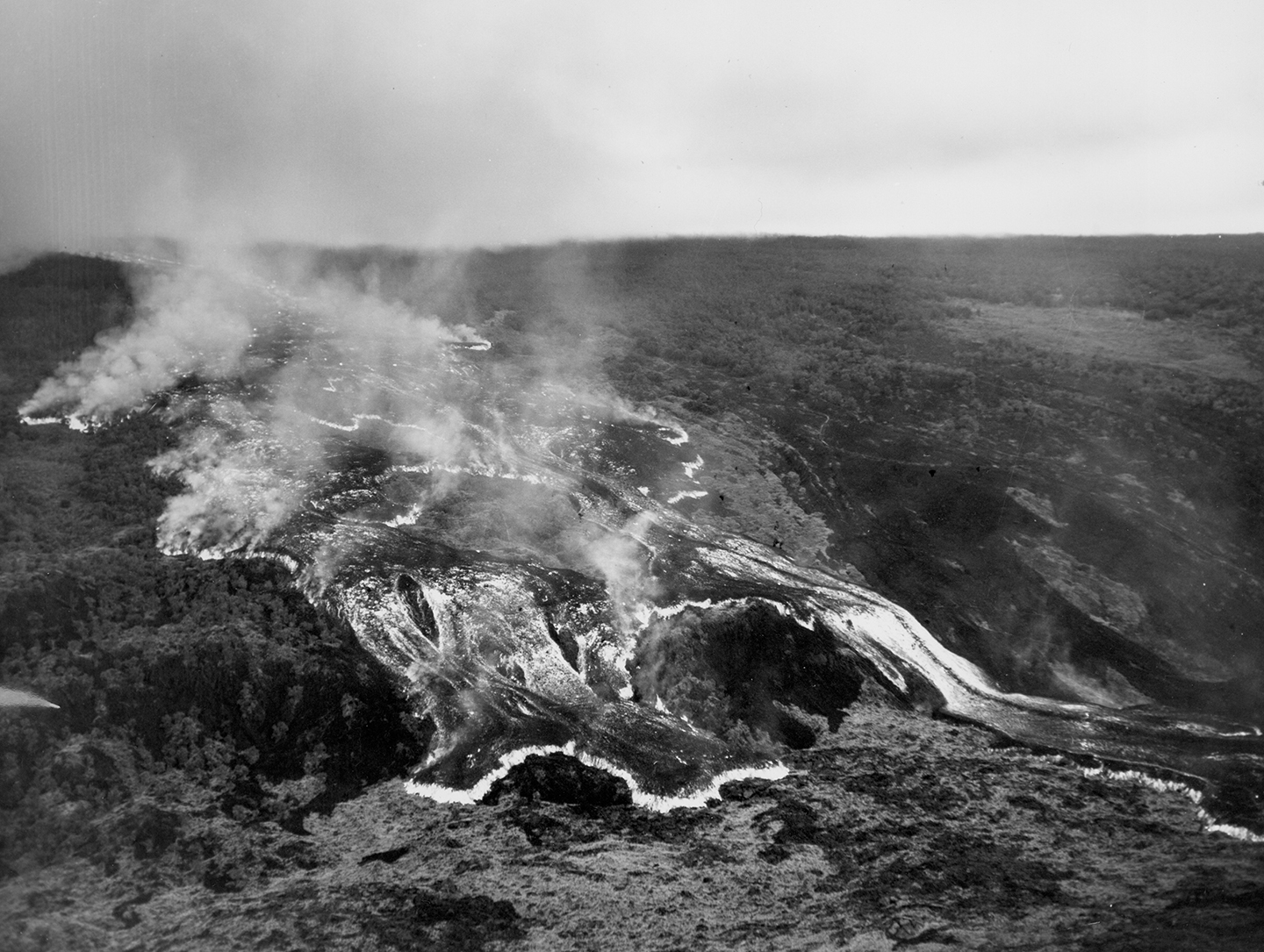
This rapidly moving ʻaʻā lava flow was one of several that advanced down the west flank of Mauna Loa during the volcano’s 1950 eruption. The massive flow, tens of meters (yards) high, traveled from the Southwest Rift Zone vent to the ocean, a distance of about 18 km (11 miles) in around 18 hours. Two earlier flows from this eruption reached the ocean in as little as three hours. All three flows crossed Highway 11 as they advanced to the sea. In this black-and-white aerial photo, incandescently hot areas on the flow appear white. Photo credit: Air National Guard, 199th Fighter Squadron.
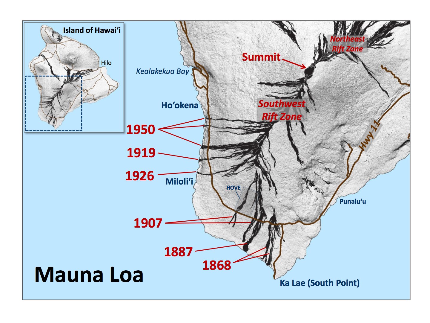
During the past 148 years, Mauna Loa Southwest Rift Zone eruptions have sent massive lava flows across Hawai‘i Island’s main road six times: in 1868, 1887, 1907, 1919, 1926 and 1950.
These flows destroyed villages, displacing residents, burned forests and ranch land, trapping cattle on isolated knolls, blocked roads, disrupting traffic, and torched telephone poles, severing communication.
Last week’s “Volcano Watch” focused on the 1868, 1887 and 1907 eruptions. This week, we describe the 1919, 1926 and 1950 lava flows, which were unlike any of the flows observed during the ongoing Kīlauea eruption.
On Sept. 26, 1919, a vent high on Mauna Loa’s Southwest Rift Zone erupted for just a few hours. Three days later, a breakout lower on the rift zone erupted fountains of lava up to120 m (400 feet) high and sent a river of lava down the volcano’s forested slopes.
Within about 20 hours, an ‘a‘ā flow several hundred meters (yards) wide crossed the circle-island “Government Road” (predecessor of Highway 11), burying the small village of ʻᾹlika. This flow can be seen today at Highway 11, Mile Markers 90–91.
ARTICLE CONTINUES BELOW AD
ARTICLE CONTINUES BELOW AD
The 1919 lava flow advanced 18 km (11 miles) in about 24 hours, reaching the sea north of Hoʻōpūloa, where it poured into the ocean for 10 days. The eruption then slowly waned until Nov. 5, when all activity ceased.
The 1926 eruption began on April 10 at the summit of Mauna Loa, but fissures soon migrated down the volcano’s Southwest Rift Zone. By April 14, three main vents were sending huge ‘a’ā flows downslope. Two days later, the main flow—4–6-m (15–20-feet) high, 150-m (500 feet) wide, advancing at 2 m (7 feet) per minute—crossed the road. This flow is visible today along Highway 11, at mile markers 87–88.
In the past 148 years, lava flows erupted from Mauna Loa’s Southwest Rift Zone have crossed Hawaiʻi Island’s main road (now Highway 11) six times. The years in which these flows were erupted are labeled in red. The location of Hawaiian Ocean View Estates (HOVE) is shown for reference. USGS map.
The 1926 flow thickened and widened as it rapidly advanced beyond the road toward the sea. On April 18, a 9–12-m (30–40 feet) high and 455–610-m (1500–2000feet) wide ‘a‘ā flow plowed through the Ho`ōpūloa village and harbor. The destruction was gradual, but complete. The eruption ended on April 26. Today you can see the extent of this flow from the coastal village of Miloliʻi.
After the 1926 eruption, Mauna Loa’s Southwest Rift Zone was quiet for 24 years. That ended in 1950 with one of the volcano’s largest historical eruptions.
On June 1, 1950, a 2.4-km- (1.5-miles) long fissure began erupting high on Mauna Loa’s Southwest Rift Zone around 9 p.m. Minutes later, the roar of lava fountains could be heard from Highway 11, up to 24 km (15 miles) away. Floods of lava streamed downslope from the rift zone.
ARTICLE CONTINUES BELOW AD
As the fissure extended farther down the rift zone, several flows raced down the west flank of the volcano. Within about two hours, the first of these flows crossed the highway and inundated the village of Pāhoehoe. All villagers reached safety, but for some, who escaped with only the clothes on their backs, it was a close call.
Thirty-five minutes later, the flow entered the ocean, creating a steam cloud that rose 3,000 m (10,000 feet) into the air. It’s noteworthy that, from vent to sea, this massive ‘a‘ā flow traveled a distance of 21 km (13 miles) in only about three hours. Two additional flows south of the first one reached the ocean in about 14 and 18 hours.
Before ending on June 23, the 1950 eruption destroyed nearly two dozen structures and cut Highway 11 in three places (visible today between Mile Markers 92 and 98), burying more than 1.6 km (1 mile) of the road.
If a Mauna Loa Southwest Rift Zone lava flow crossed Highway 11 today, the lives of thousands of residents would be significantly impacted—even if they do not live in the immediate path of the flow. At the very least, travel to homes, schools and workplaces would be disrupted.
A Mauna Loa eruption is not imminent at this time, but the volcano will erupt again—and chances are that it will occur in your lifetime. So, now is the time to consider how you would cope with the disruptions caused by lava crossing the highway.
ARTICLE CONTINUES BELOW AD
Questions about Mauna Loa are answered on the Hawaiian Volcano Observatory website.
Volcano Activity Updates
Kīlauea continues to erupt at its summit and East Rift Zone. During the past week, the summit lava lake level varied between about 27 m and 36 m (88–118 feet) below the vent rim within Halema‘uma‘u Crater.
On the East Rift Zone, the June 27 lava flow may have stopped, but HVO scientists continue to watch for signs of activity. On the flanks of Pu‘u ‘Ō‘ō, only the eastern breakout remained active. As of June 8, this flow was 2.7 km (1.7 miles) long and continued to advance to the southeast. No lava flows were threatening nearby communities.
Mauna Loa is not erupting. A small earthquake swarm occurred beneath the volcano’s west flank on May 28–31. Most of these earthquakes were about 5–8 km (3–5 miles) deep, and the largest magnitude was 2.8. This swarm is expected behavior and does not represent a significant change for Mauna Loa. Seismicity rates have since decreased, but are still elevated above long-term background levels. Deformation related to inflation of a magma reservoir beneath the summit and upper Southwest Rift Zone continues, with inflation recently occurring mainly in the southwestern part of Mauna Loa’s magma storage complex.
No earthquakes were reported to be felt on the Island of Hawaiʻi this past week.
Volcano Watch is a weekly article and activity update written by U.S. Geological Survey Hawaiian Volcano Observatory scientists and affiliates.
Call for summary updates at (808) 967-8862 (Kīlauea) or (808) 967-8866 (Mauna Loa); email questions to [email protected].
This comments section is a public community forum for the purpose of free expression. Although Big Island Now encourages respectful communication only, some content may be considered offensive. Please view at your own discretion. View Comments