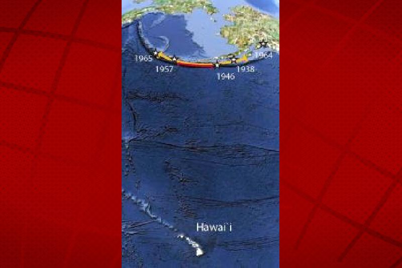
The map showing the Aleutians with respect to Hawai’i. UHM SOEST image.
A study published by a team of researchers at the University of Hawai’i at Manoa estimated in a study published this week that an earthquake with a magnitude of 9.0 or higher in the Aleutian Islands could happening at a nine percent chance over the next 50 years.
The research suggests that an earthquake in the area with that magnitude would create enough power to create a mega-tsunami that could threaten Hawai’i.
Previously, the State of Hawai’i estimated that an earthquake of that magnitude, followed by a mega-tsunami, could cause damage in the $40 billion dollar range and affect over 300,000 people.
“Necessity is the mother of invention,” said Rhett Butler, lead author and geophysicist at the UHM School of Ocean and Earth Science and Technology. “Having no recorded history of mega-tsunamis in Hawai‘i, and given the tsunami threat to Hawai‘i, we devised a model for Magnitude 9 earthquake rates following upon the insightful work of David Burbidge and others.”
ARTICLE CONTINUES BELOW AD
ARTICLE CONTINUES BELOW AD
The earth’s crust is composed of numerous rocky plates. An earthquake occurs when two sections of crust suddenly slip past one another. The surface where they slip is called the fault, and the system of faults comprises a subduction zone.
Hawai‘i is especially vulnerable to a tsunami created by an earthquake in the subduction zone of the Aleutian Islands.
Butler and co-authors Neil Frazer and William Templeton created a numerical model based only upon the basics of plate tectonics: fault length and plate convergence rate, handling uncertainties in the data with Bayesian techniques.
To validate this model, the researchers utilized recorded histories and seismic/tsunami evidence related to the five largest earthquakes (greater than Magnitude 9) since 1900 (Tohoku, 2011; Sumatra-Andaman, 2004; Alaska, 1964; Chile, 1960; and Kamchatka, 1952).
ARTICLE CONTINUES BELOW AD
“These five events represent half of the seismic energy that has been released globally since 1900,” said Butler. “The events differed in details, but all of them generated great tsunamis that caused enormous destruction.”
In an effort to further refine the probability estimates, the researchers took into account past prior to recorded history tsunamis through evidence preserved in geological layers in coastal sediment, volcanic tephras, and archeological sites.
“We were surprised and pleased to see how well the model actually fit the paleotsunami data,” said Butler.
Using the probability of occurrence, the researchers were able to annualize the risk. They report the chance of a Magnitude 9 earthquake in the greater Aleutians is 9% ± 3% in the next 50 years.
ARTICLE CONTINUES BELOW AD
Hence, the risk is 9 percent of $40 billion, or $3.6 billion.
Annualized, this risk is about $72 million per year. Considering a worst-case location for Hawai‘i limited to the Eastern Aleutian Islands, the chances are about 3.5 percent in the next 50 years, or about $30 million annualized risk.
In making decisions regarding mitigation against this $30 to $72 million risk, the state can now prioritize this hazard with other threats and needs.
The team is now considering ways to extend the analysis to smaller earthquakes, Magnitude 7-8, around the Pacific.
This comments section is a public community forum for the purpose of free expression. Although Big Island Now encourages respectful communication only, some content may be considered offensive. Please view at your own discretion. View Comments